News and Information on People, Places and Things in the #LehighValley! You may want to see this! We are roving reporters, we will rate you and your business!
The 2nd game of our LIVE softball coverage coming up at 7pm on SEN2📺
Tune in as Stroudsburg & @_EHSAthletics take the field in the EPC semifinals!
https://t.co/719jZctTqK
@sectv
COVER YOUR PLANTS! FROSTS LIKELY NEXT FEW NIGHTS...
Tonight through Monday night will feature the potential for frosts across the state as temperatures will be slated to drop into the 30s. While the air temperature may only get as low as 32 - 36 each night, the immediate surface is usually colder than the air temperature, which allows for frost development.
A good chunk of western PA is under a Frost Advisory for late tonight into Friday morning. Temperatures as low as 32 will result in frost formation. Frost could harm sensitive outdoor vegetation. Sensitive outdoor plants may be killed if left uncovered.
** SEVERE WEATHER RISK SCALES FOR TODAY 4/14**
A low-end severe weather risk is possible later this afternoon and into the evening, primarily across the northern half of Pennsylvania. This is a lower-end risk, but keep in mind that if you are planning to be outdoors in the PM or early evening. There will be enough instability and wind shear, the ingredients needed to develop this risk, as we see multiple boundaries from leftover overnight storms in the Midwest heading our direction.
Today's highest risk is damaging winds (2/10), with large hail maximizing at a 2/10, and the tornado risk is a 1/10.⛈️
It is good to remain weather-aware and be prepared for changing weather conditions! #PAwx #Pennsylvania #SevereWeather #Severe
** WINDY FRIDAY AFTERNOON / EVENING **
Friday the 13th is about to get even more spookier than it probably should, and that is thanks to Mother Nature! We will see increasing wind gusts across the region tomorrow afternoon and evening as we see a very strong low-pressure system move over the Great Lakes region. This low-pressure system will have a tight pressure field, which will allow for higher wind gusts, mainly across western Pennsylvania. There will also be scattered rain/snow pellet showers across the state tomorrow, but any accumulations are generally not expected due to the daylight + temperatures above freezing.
AREA A: Peak wind gusts of 50 - 55 MPH expected Friday. Strong wind gusts could blow down trees and power lines. This may result in power outages. High winds may make travel difficult, especially in high-profile vehicles. Non-secured objects and trash cans will be blown away.
AREA B: Peak wind gusts 40 – 50 MPH. A few gusts over 50 MPH are not ruled out (mostly hills). Higher wind gusts may result in a few downed trees and power lines. This may result in isolated or scattered power outages. Non-secured objects may be blown around.
ZONE C: Peak wind gusts 30 – 40 MPH. A few gusts over 40 MPH are not ruled out. Issues are generally not expected, although brief higher gusts may down a tree or two. Power outages are not expected but may occur in an isolated instance.
Be winter-ready with @dmc_snow an exclusive provider of commercial snow & ice management across Pennsylvania, New Jersey, and Delaware. From distribution centers and warehouses to office parks, shopping centers, and retail stores, we keep your property clear and business running all season long.
Stay tuned for updates. If you have anything outdoors that may be blown around, make sure to bring it indoors and/or tie it down. Also, it will be a bad day to have a garbage day, some of the trash cans might end up across the street in western PA!
** WINTER STORM TAKING SHAPE **
5:42 PM 2/22/2026
Our bands of moderate to heavy snow are beginning across eastern Pennsylvania with moderate snowfall across central Pennsylvania from an inverted trough. What are you seeing out your window? The heaviest of the snow will begin across eastern Pennsylvania now through 9 PM, with the heaviest occurring overnight through sunrise. Please stay home! ❄️ #PAwx #Snow #Blizzard
** DANGEROUS WIND CHILLS, POSSIBLE POWER OUTAGES DUE TO HIGH WINDS IN PENNSYLVANIA THIS WEEKEND **
The coldest air of the season is on the way to Pennsylvania this weekend as a strong blast of arctic air arrives out of northern Canada. An arctic front will sweep through the state Friday night into Saturday morning, increasing the wind gusts and significantly lowering the temperatures. Due to the higher wind gusts, isolated or scattered power outages may be possible. This is something to take seriously in case of emergencies such as power outages or a car breakdown as the cold could easily make your situation life-threatening. Please take proper precautions this weekend and stay warm!
https://t.co/0gCly4bFAo
** DANGEROUS WIND CHILL VALUES FRIDAY NIGHT - SATURDAY MORNING **
Here is an updated look at the potential wind chill values late tonight into Saturday morning across the state. A strong arctic cold front will usher in colder air west-to-east across Pennsylvania after midnight on Saturday, allowing for a much colder airmass to move in. With this front, we should expect wind gusts of 40 to 50 mph, which will allow for frigid wind chill values as we wake up on Saturday. As we head into Saturday afternoon and again into the night, there will not be much improvement with many areas staying below zero.
When wind chill values drop this low, the cold air can affect your body much faster than the actual air temperature. Strong winds pull heat away from exposed skin, which greatly increases the risk of frostbite and hypothermia. Even temperatures that don’t seem extreme can become dangerous when combined with wind, so it’s important to take precautions anytime wind chills fall near or below zero. At wind chills of –20°F or lower, frostbite can begin in as little as 15–30 minutes on exposed skin.
If you are planning to be outdoors late tonight through Saturday and even into Sunday, make sure to dress in multiple loose-fitting layers to trap heat and stay dry. Start with a moisture-wicking base layer, add an insulating middle layer like fleece or wool, and finish with a windproof and waterproof outer shell. Cover exposed skin as much as possible by wearing a hat, gloves, a scarf, and insulated waterproof boots with thick socks. Hands, ears, nose, and cheeks are usually the first areas to develop frostbite.
Stay tuned for updates!
-Denys
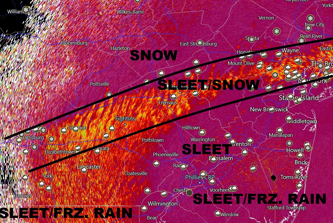
Current precipitation type breakdown...
Battlezone is I-78 vicinity next few hours which will alternate from heavy sleet to a mix of sleet and snow and snow over the next several hours. South of there, not much hope for a change back to snow.
** MAJOR WINTER STORM SCENARIOS FOR PENNSYLVANIA **
I have been hearing for years, "When is the big one coming"? Well, folks, this pattern is what you have been waiting for years or decades. The biggest major winter storm forecast of my lifetime (I am 23 years old) is approaching us this weekend, bringing major impacts to much of Pennsylvania. Hurricane hunters have flown into the storm system over the Pacific overnight, gathering great data to ingest into model guidance. This has led to a large shift toward a more northerly and amplified storm system. ⚠️❄️
ALL OF THE DETAILS ON THE THREE SCENARIOS, TIMING, AND TEMPERATURES ARE ON THE BLOG POST!
READ HERE: https://t.co/U116UE4Lhp
Be winter-ready with @DMC_SNOW an exclusive provider of commercial snow & ice management across Pennsylvania, New Jersey, and Delaware. From distribution centers and warehouses to office parks, shopping centers, and retail stores, we keep your property clear and business running all season long.