Product marketer @Esri, @uofsandiego alum, mom of 3 great kids & wife of 1 great husband, luv geography, maps, traveling, & storytelling (all tweets are my own)
#ArcGISHub extends ArcGIS Online and ArcGIS Enterprise, enabling organizations to share, collaborate, and engage with their communities. Follow us on LinkedIn to get updates & stay connected.
ArcGIS Online: https://t.co/8VzY8t3PwR
ArcGIS Enterprise: https://t.co/G2JB3ykKBm
Shoutout to all the organizations building living digital twins and revolutionizing how they see and respond to the world in real-time. This is where innovation meets real impact...build a geospatial nervous system for the world! 🙌
The world doesn’t stop and neither should maps. 🗺️ Jack Dangermond discusses how living digital twins deliver real‑time visibility into operations for faster, more strategic decisions. https://t.co/1yKeTFDpYb
Check out the Q&A from our What's New in ArcGIS Hub webinar! Learn about new developments in Hub, and get clarity on questions regarding accessibility, sharing content on your hub site, messaging members of a group, and more. https://t.co/6yy1cT1uba
It’s crucial to keep inclusion in mind when creating maps, to ensure your audience can access and see themselves reflected in your work. Read about Patricia Flores White's experiences making GIS accessible, and the #ArcGISHub site she shared her work on.
https://t.co/K5DfoITPcK
Jack Dangermond shares technical observations of advances in the geospatial industry, along with a sweeping vision for an open and connected global geospatial infrastructure. #ArcGISHub helps facilitate this vision. Read now in xyHt: https://t.co/roldlCsB5H
The California Nature hub beautifully presents California’s 30x30 goal. With an abundance of informative videos, an annual progress report, and great maps and open data, it inspires us toward a sustainable future. #HubsWeLove
Explore: https://t.co/PE17DaKrl6
Have some new ideas you’d like to see implemented in #ArcGISHub? Post them on the ArcGIS Hub Ideas section of the Esri Community. We’d love to hear your thoughts. #HubHints
Post your idea: https://t.co/SHqgV4QWw2
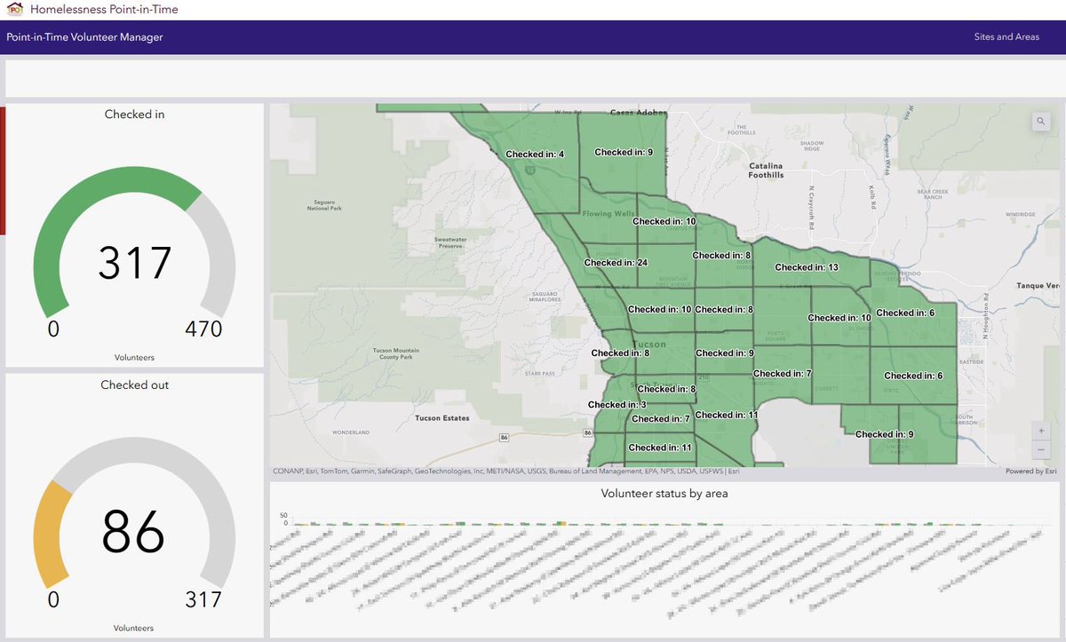
The City of Tucson, AZ, adopted the Homelessness Point-in-Time Count solution for its 2025 PIT count. Using #ArcGISHub, the solution enabled the city to streamline their volunteer management, resulting in increased turnout.
Learn more: https://t.co/caSCjyVklK
The Metal Earth hub showcases the global initiative spearheaded by the students at Laurentian University to improve the science of targeting and finding ore bodies. This innovative work is being done at an unprecedented scale. https://t.co/IlmADJ5171 #HubsWeLove@LaurentianU
There’s a lot to #ArcGISHub, and we have the documentation to get you in the know. If you want to find which doc pages are our most popular, check out this blog, and get your journey started. #HubHints
Explore: https://t.co/ULy5LsKUMV
Houston, TX, uses GIS to modernize their infrastructure management. Their next-gen public works boosts operational efficiency, and #ArcGISHub allows residents to navigate the city’s infrastructure and provide edits on asset condition.
Learn more: https://t.co/35I0ekkxG1
Enhanced events has arrived. With great new features like the ability to share events with public or private groups, automatically update attendees, and more, enhanced events improves on your ability to gather your community to achieve common goals.
https://t.co/g4r8lEgN6F
Workspaces is here!🎉 After a year in beta and amazing feedback from our community, workspaces, the new site management experience in #ArcGISHub is now generally available. Managing content, groups, and people just got a major upgrade. 😎
Explore: https://t.co/Ibx91K17od
Get your Hub schedule ready for #EsriUC2025! Attend sessions and speak with Esri experts and peers regarding everything #ArcGISHub. Our UC blog will give you a sneak preview of what's in store.
Read more: https://t.co/Uzj4sEUTWj
Introducing configurable catalogs, a powerful new way to organize content and event collections in #ArcGISHub. Configurable catalogs allow for filters and enhanced customization, as well as control over appearance.
Explore: https://t.co/bc0POD7Xho
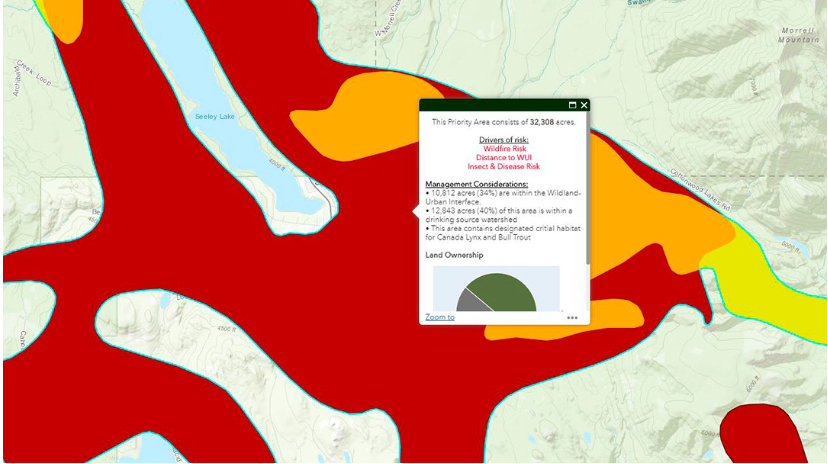
Montana’s DNRC implemented #ArcGISHub to transform their static Forest Action Plan to a living document that easily communicates changes to forest health and wildfire risk, helping remove barriers to access.
Lean more: https://t.co/t5NW9GZRvb
Can’t wait to see you at #EsriUC2025! Make sure to register for our Community Engagement SIG: Using Hubs for Deeper Collaboration. Learn how organizations across industries use ArcGIS to collaborate and engage both internally and externally.
Register: https://t.co/HSoQYho5JP
With #EsriUC2025 coming soon, make sure you’ve registered for the Geospatial Ecosystems SIG. Peers and Esri experts will discuss how to maximize your ROI for SDIs, a fundamental part of collaboration to address shared challenges. https://t.co/5iCaBXLUvY