Remote sensing is the technique used to record and take images of a thing or an area. In archeology (study of remains), remote sensing is one of the tools that has led to archeological activities and research.
https://t.co/tqj3QQaqpM
1. There are more ‘Geospatial Niche’ companiesIf you work in GIS, you have seen tremendous growth in software sales, services, and solutions over the past 20 years.
https://t.co/o4MgqL6Dg6
What is GIS Science (GISc)
In the US, there are about 120 colleges that offer GIS focused degrees and certificates. The majority of these are limited with general classes in GIS, Cartography, and Database Development. #Certificate#GISc#Programs#top
https://t.co/d3hYNQk3dg
An experimental flapping-wing design modelled on the wings of dragonflies. Courtesy University of South Australia.
In research that could lead to more efficient flapping-wing drones, University of South Australia PhD students are investigating the #Drag
https://t.co/8p8dQb0Uev
Although Census boundaries have arrived, the Census 2020 population data won’t be here until the fall. Read on for more details about how and why we have to wait.
The Decennial Census is mandated by the U.S. #Census#Data#ready
https://t.co/WPFpNybzYz
NASA along with SpaceX has launched four astronauts to the International Space Station (ISS), in the third crewed mission of the US commercial rocket company in less than a year’s time, as reported by a news agency. #astronauts#Geospatial#ISS#launch
https://t.co/4bFh8zIDl5
Geography is changing faster than ever before. Global warming and COVID-19 are pushing change at an unprecedented speed, modifying our environments, markets, and society.
https://t.co/BxEvA8K42Q
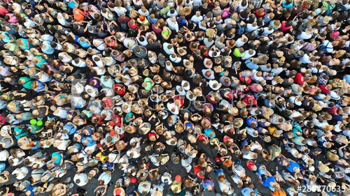
How Location-Based Services Can Help to Locate Mass Social Gatherings
Social Distancing and Illegal Assemblies
The coronavirus pandemic is changing our living habits.
https://t.co/wf0d04VsPZ
The Intelligence Advanced Research Projects Activity (IARPA), within the Office of the Director of National Intelligence, announced a multi-year research effort called the Space-based Machine Automated Recognition Technique (SMART) program.
https://t.co/mZ643UKV0G