FLOOD WARNING FOR NORTH CENTRAL KANSAS. Heavy rain of over 5 inches has caused widespread flooding, closing roads in Osborne and Mitchell counties. Surrounding areas have also had similar totals. Turn around, don't drown! #kswx#flood#wxtwitter#kansas
FLOOD WARNING FOR HARLAN AND PHELPS COUNTIES IN NEBRASKA. Widespread flooding and roadway damage reported near Ragan with over 5 inches of rain. Do not drive on flooded roads! #newx#flood#nebraska#wxtwitter
HEAVY RAIN ALERT: Over 5 inches of rain has fallen in parts of western Kansas with more rain continuing. Watch for flash flooding and never drive through flooded roads! #kswx#kansas#flooding#wxtwitter
Severe Thunderstorm Warning CANCELLED for SE Otero County, NM and NE Hudspeth County, TX. The storm has weakened below severe limits, but gusty winds and heavy rain are still possible. #nmwx#txwx#severe#wxtwitter
SEVERE THUNDERSTORM WARNING for SE Otero County, NM and NE Hudspeth County, TX until 2:45 AM MDT. 60 mph wind gusts and a TORNADO IS POSSIBLE. #nmwx#txwx#severe#wxtwitter
The 00z Nadocast shows the highest wind risk over South Dakota and northern Nebraska, with a lesser threat from eastern Kansas to central Iowa. Not official; consult https://t.co/0FDU0gpAKI.
#wxtwitter#weather#wxsd#wxne#wxks#wxmo#wxia#wind
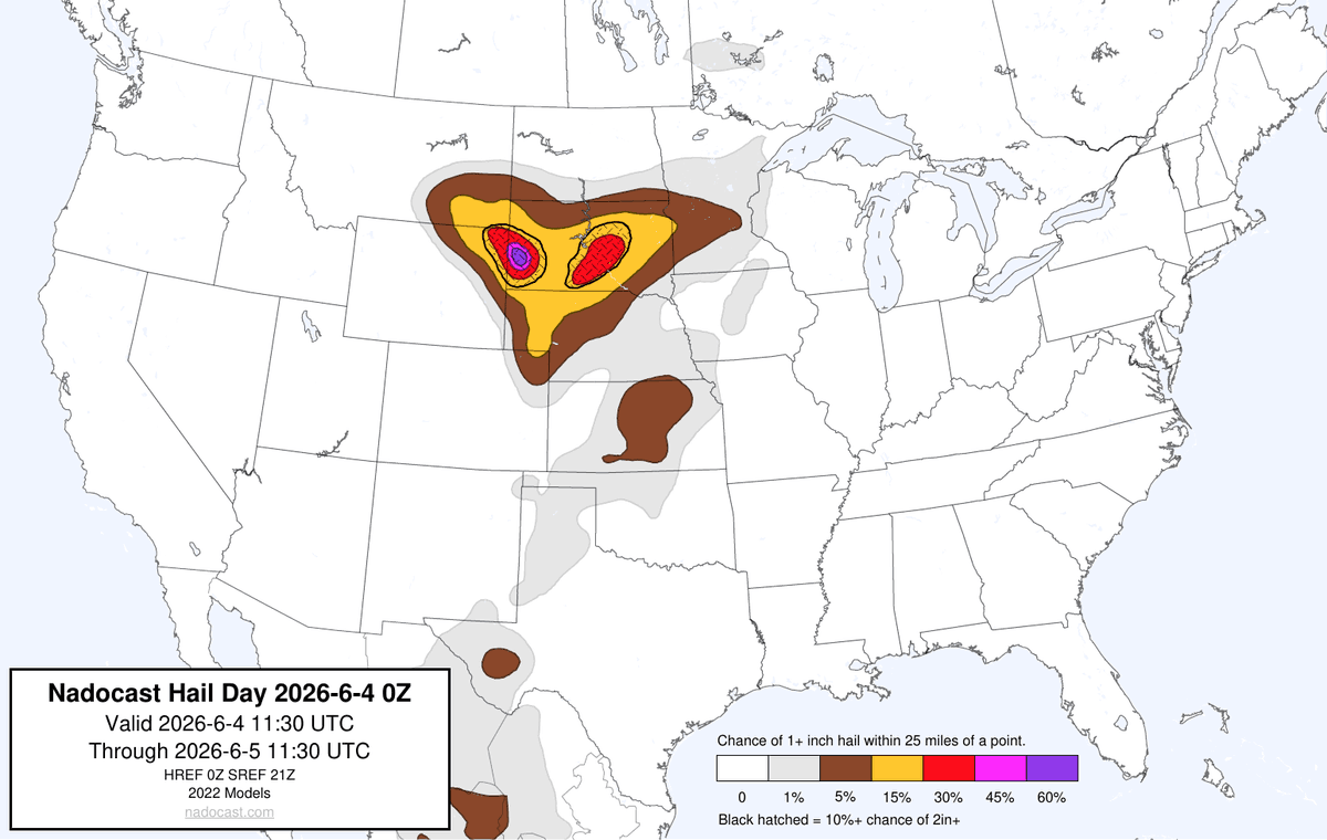
The 00z Nadocast shows a significant hail risk over South Dakota and northern Nebraska, with a lesser threat extending into Kansas. Not official; consult https://t.co/0FDU0gpAKI.
#wxtwitter#weather#wxsd#wxne#wxks#wxmo#wxia#hail
The 00z Nadocast shows the highest tornado risk from northeast Kansas into southwest Iowa, with a lesser threat in South Dakota. Not official; consult https://t.co/0FDU0gpAKI.
#wxtwitter#weather#wxks#wxne#wxmo#wxia#wxsd#tornado
Nearly stationary thunderstorms are over Clovis, Farwell, Portales, and Elida. Over 2 inches of rain has fallen in Clovis. Stay off flooded roads. #nmwx#txwx#clovis#weather#wxtwitter#flooding
Thunderstorms with increasing lightning are moving northeast north of White Sulphur Springs. No severe weather is expected at this time. #mtwx#montana#weather#wxtwitter#thunderstorm
The Severe Thunderstorm Warning for Otero, NM and Hudspeth, TX has been CANCELLED. The storm has weakened below severe limits. Heavy rain and gusty winds remain possible. #txwx#nmwx#weather#wxtwitter
Thunderstorms with frequent lightning are increasing across western Kansas, including Utica, Plains, Larned, and Great Bend. Storms are moving north-northeast. No severe weather is expected. Stay indoors when thunder roars. #kswx#kansas#weather#wxtwitter
SEVERE THUNDERSTORM WARNING for north central Hudspeth County, TX and south central Otero County, NM. 60 mph wind and nickel size hail are possible. Move to an interior room now! #txwx#nmwx#severewx#wxtwitter#storm
Thunderstorms with lightning moving through Hutchinson, New Ulm, Mankato, and Lakeville toward Minneapolis, St. Paul, and Faribault. Stay indoors when thunder roars. No severe weather expected. #mnwx#minnesota#weather#wxtwitter#storm
Moderate rain and lightning are expected as a cluster of thunderstorms moves slowly northeast toward Key West. Mariners and residents should remain alert for changing conditions. Seek shelter indoors if thunder roars. #flwx#florida#keywest#weather#wxtwitter