Scattered clouds across the area right now. We are still anticipating strong to severe thunderstorms this afternoon and evening that could bring localized heavy downpours. A heat advisory remains in effect until 8pm Friday.
Severe thunderstorms are possible Saturday during the late afternoon and evening. The main threat will be damaging wind gusts, but large hail and localized flash flooding can not be ruled out.
#NYCwx#NYwx#CTwx#NJwx
No this is not a joke…Retro Weather Channel is officially back! 🎶 Head to https://t.co/sJgpOSHVgR enjoy RetroCast Now for your forecasts in the way you know and love. 💙🎷☀️
A reminder that this weekend (Sun. 2am) we will jump ahead one hour as we begin DST. Bad news: that precious extra hour of sleep you were hoping for this weekend is gone. Good news: Sunset on Sunday will be 6:51pm.
The receipts are in!
❄️Warwick: 37.9”
❄️Islip: 31”
❄️Newark: 27”
🌬️Montauk: 84mph winds
Late-February blizzard goes down as an all-timer
#nywx#njwx#ctwx#blizzard2026
1pm Snowfall Observation Update from Major Reporting Sites:
Islip, NY: 29.1" - PRELIM, UNOFFICIAL record for largest snowstorm since 1963. Will be re-examined. Previous 27.8" Feb 9-10, 2013.
Newark, NJ: 27.1"
LGA: 22.2"
JFK: 19.8"
Central Park, NY: 19.7"
8:30am: Heavy snow continues. Strong wind gusts will continue this morning leading to whiteout/blizzard conditions as well as significant blowing and drifting of snow. This absolute beast of a storm just keeps cranking.
BLIZZARD 2026: Blizzard to near blizzard conditions continue to slam Long Island with thundersnow and wind gusts to near 55 mph. Blizzard warning continues until 6 p.m. https://t.co/F0iOeLPLAi
#blizzard#snow#longisland
7:30 pm Snowfall Reports Update:
1 NW Center Moriches, NY: 3.6"
NWS NY: 2.5"
Newark, NJ: 2.0"
Islip, NY: 2.0"
Central Park, NY: 1.8"
JFK: 1.7"
LGA: 1.7"
Bridgeport, CT: 0.8"
Follow along with our public information statements through the event:
https://t.co/LsVoE8yEsB
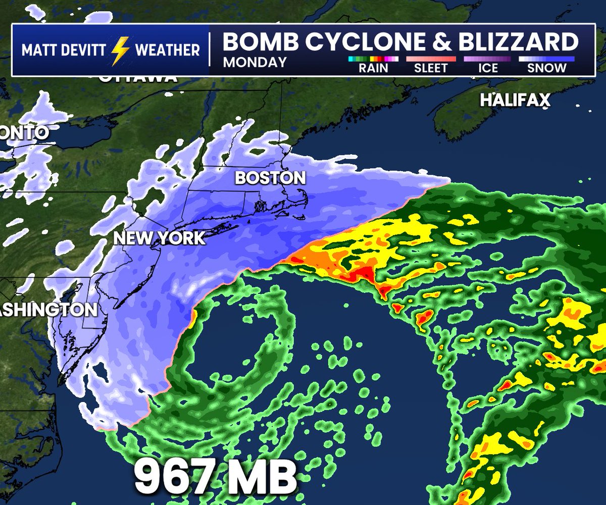
If this was Hurricane Season, the Northeast Blizzard would be comparable to a Category 2 Hurricane in terms of pressure (967 mb by Monday). Note the eye starting to develop on future radar from this 1,200 mile-wide Nor'easter too. Snow totals over 20"+ in spots expected with hurricane force gusts between 75 - 85 mph from Long Island to Nantucket and Cape Cod. Certainly could be a storm for the record books in hardest hit areas. Stay indoors and take it seriously.
[1:47 pm Update]: The major winter storm is taking shape to our south. Conditions will rapidly deteriorating late this afternoon into the evening with snow accumulations ramping up from south to north. Travel should be restricted to emergencies only this evening into Monday.
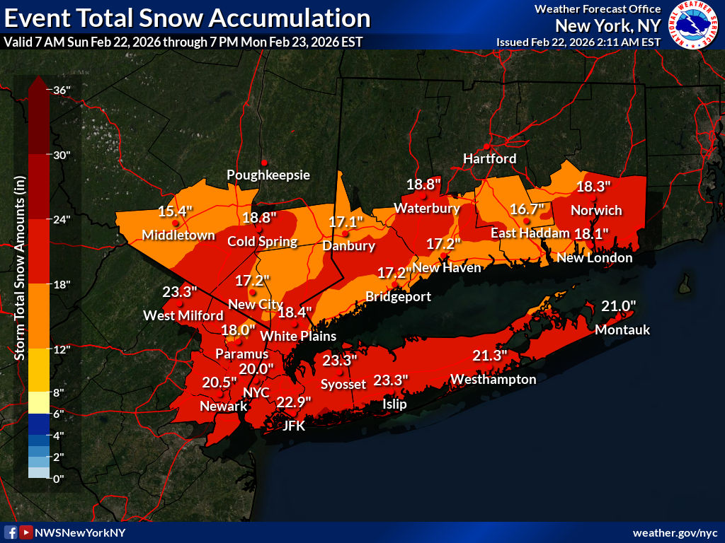
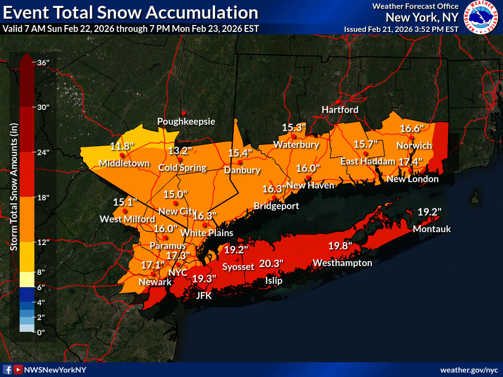
A major winter storm w/ blizzard conditions impacts the region Sunday and Monday.
❄️ Total snow: 12-20", locally 24"+
💨 Wind gusts: 50-60 mph along coast
Expect white-out conditions Sun night into Mon AM. Travel will be dangerous, if not impossible.
💻 https://t.co/TePWIEDYix
With blizzard warnings now in effect for the entire coast, including the NYC metro, it is time to review blizzard conditions.
The image here details the criteria for blizzard conditions to be met.
#nycwx#nywx#liwx#ctwx#hvwx#njwx