Grateful for all the blessings in my life... Love spending time with family & friends, learning about health and nutrition, yoga, working out, and reading.
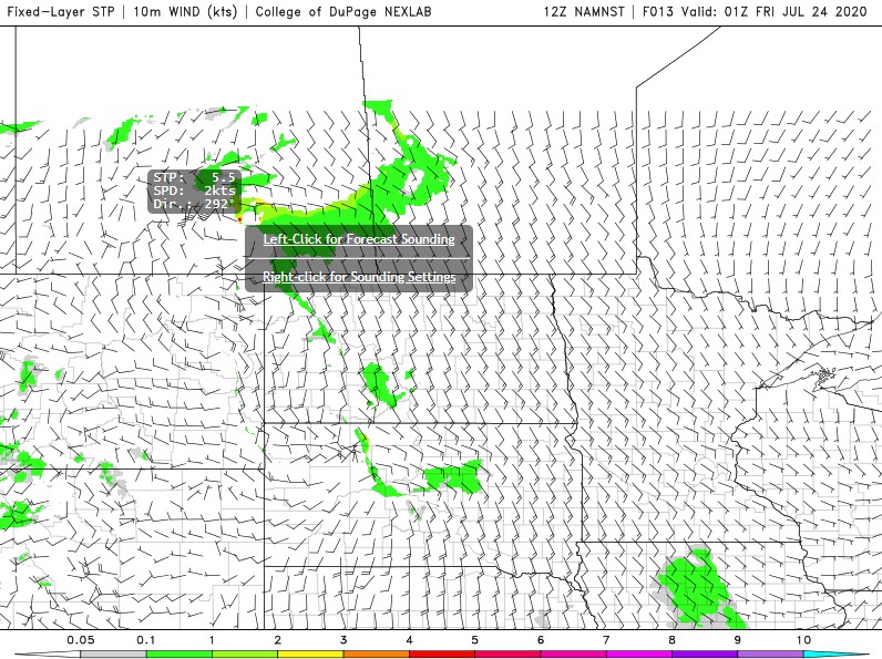
Tornado risk has increased to a 5.5 on the Significant Tornado Parameter from the latest NAM Nest forecast model just south of the city of Regina at 7pm this evening. That is very high, anything over 2.0 can bring a low risk of tornadoes. .. #skstorm#skwx
Any tornado threat, again within the severe likely area and from Prince Albert-Regina, #SKstorm, would be through the mid to late afternoon early in storm life cycle. Cap looks to build back in through the evening hours limiting the risk and should reduce the severe threat too
TORNADO THREAT in Saskatchewan looks to be maximized near surface low track, on north/northeast side of jet streak and front left quadrant of banana shaped low, likely west of Saskatoon with most favorable low-level shear profiles. LLJ ramps up late evening southern SK #skstorm
Primary severe weather threat today will be in far eastern AB and through western, central, and southern SK, near the surface trough/low.
We'll be playing the secondary target in southcentral AB looking for storm/boundary interactions. #abstorm#skstorm
There are several weather risks for Alberta today, including severe thunderstorms with the potential for producing tornadoes.
More details on timing with Meteorologist @jwhittalTWN below. ⬇️ #ABstorm#BCstorm#SKstorm
"Going chasing up in Fox Creek today!" - Said No One 😂
Severe thunderstorms on tap for Alberta later today and overnight. Main threats include golf ball to egg sized hail and strong wind gusts. Isolated thunderstorms expected everywhere else.
#ABStorm#SKStorm#MBStorm
Several computer model runs have been suggesting the probability of strong supercell storms and possible tornadoes in the Regina area Wednesday July 24th 2019. #skstorm
We'll see some northwesterly winds pushing thunderstorms downwards towards the extreme SE, where severe thunderstorms are possible. Moderate t-storms that could bring 100 km/h gusts and hail the size of loonies possible for most of south/central #Sask#SkStorm#YQR#YQRam
Severe weather threat returns to the prairies tomorrow in Alberta and Saskatchewan. Threats include golf ball to egg sized hail, strong wind gusts and a chance of the T-word in Alberta and dime to golf ball size hail and strong wind gusts in Saskatchewan. #ABStorm#SKStorm
Risk of #thunderstorms, potentially severe, looks to be in the cards again today. #Hail size could range from 2-5 cm ( Nickle to Egg sized). Straight line #wind gusts of 100 km/hr AND a risk of #tornadoes, especially between #Edmonton & Sask border. #ABstorm#SKstorm#BCstorm