@deb30911@IMFNews Spot on! IMF billions prop up Abiy’s #Ethiopia warmongering regime fighting #Tigray, #Amhara & #Oromia while doctors starve on inflation wages. Now his #RedSea obsession fuels invasion plans against #Eritrea. Stop funding the ethnic butcher or whatever his next plan is 🤪
Biniam Girmay took the overall 4th place by scoring 14 points, from the peloton in the intermediate sprint Tour du France 2026 . Bini powered past Mads Pedersen and Jasper Philipsen with a strong sprint to take the victory.
"I am super happy and super motivated to start, to go for stage wins, and chase the green jersey," 💚@GrmayeBiniam@NSNCyclingTeam #Eritrea @CyclingAfrica
ETHIOPIA — #BREAKING 🚨 The message coming from Ethiopia's own military leadership is becoming increasingly difficult to ignore.
Only days after Maj. Gen. Alemshet Degfie publicly questioned PM Abiy Ahmed's «military-first» approach to governing the country's political crises, another senior military figure has delivered an equally sobering assessment.
Maj. Gen. Alemshet pointed out that Ethiopia's military spending over the past five years has reportedly exceeded the estimated $11 billion spent by the Derg regime during its entire 17-year rule.
His message was clear: Ethiopia cannot continue attempting to solve political problems through military means, and the country needs less conflict and more political resolution.
Now, Field Marshal Birhanu Jula, Chief of the General Staff of the Ethiopian National Defense Force, has painted an even bleaker picture of the country's condition.
He was quoted as saying that, «Ethiopia has become a nation where lawlessness prevails, peace and development have disappeared, its borders can no longer be effectively defended, its sovereignty has been weakened, internal conflict has become seemingly endless, foreign adversaries can intervene and influence events inside the country, and death, suffering, and misery have become defining features of everyday reality.»
Verbatim : «ኢትዮጵያ ስርአት አልበኝነት የነገሰባት: ሰላምና ልማት የጠፋበት: ዳር ድንበር መከላከል የማይቻልባት: ሉአላዊነቷን ያጣች እርስ በርሱ የሚተላለቅ: የውጭ ጠላት እንደፈለገ ገብቶ ዜጎቿን የሚያጫርስበት: የሞት: የመከራና የሰቆቃ ሀገር እንደሆነች መወሰድ ይገባዋል::»
Whether one agrees with every aspect of these assessments or not, it is remarkable that such stark warnings are now coming from the highest ranks of Ethiopia's own military establishment.
When senior commanders begin describing the country's trajectory in such terms, the conversation is no longer merely political. It becomes a warning about the direction of the Ethiopian state itself.
These tank graveyards are a reminder to the world of the 30-year war and the immense sacrifices made. They stand as a symbol of how #Eritrea defended itself against #Ethiopia's territorial ambitions and preserved its independence.
📽 : Vlogger Matt
The Escarpment of the Eritrean Highlands and Asmara's Enviable Location *
(Who wouldn't want to see it at least once in a lifetime?)
(By Pasquale Santoro) - Few places in the world possess such an extraordinary relationship between geography and history as the escarpment of the Eritrean Highlands. Someone looking at a map might think they are simply seeing a plateau. Yet anyone who travels the road from Massawa to Asmara immediately realizes they are witnessing one of Africa's most spectacular natural landscapes.
The Eritrean Highlands form the northernmost extension of the Ethiopian Plateau. Over millions of years, the tectonic movements that created the Great African Rift Valley uplifted immense rock masses, forming a plateau between 2,000 and 2,500 meters (6,560 to 8,200 feet) above sea level. Along its eastern edge, the land does not gently slope toward the Red Sea. Instead, it plunges dramatically in a colossal escarpment, the famous Eritrean escarpment, a natural wall that drops from over 2,300 meters (7,545 feet) at Asmara to nearly sea level near Massawa in just a few kilometers.
The escarpment is far more than a geological curiosity.
It is a true natural fortress.
From the east, it appears as an immense wall of crystalline rock, deeply carved by gorges and ravines through which torrential streams flow only during the rainy season. The cliffs are so steep that, for centuries, the only connections between the coast and the plateau were narrow trails traveled by men and mules.
The traveler experiences what feels like an abrupt transformation of the world.
Behind lies the scorching, arid coastal plain.
Ahead stretches a green, breezy, fertile plateau.
It is one of the most striking environmental contrasts anywhere on the African continent.
The escarpment's greatest importance lies in its influence on climate.
Massawa, on the Red Sea coast, is one of the hottest cities on Earth. During the summer, temperatures frequently exceed 45°C (113°F), accompanied by extremely high humidity.
Asmara, little more than one hundred kilometers away, enjoys a remarkably mild climate.
Situated at approximately 2,325 to 2,350 meters (7,628 to 7,710 feet) above sea level, the city has an average annual temperature of around 17°C (63°F), with cool nights even during the summer.
This difference, which can exceed thirty degrees Celsius on the same day, is one of the most remarkable climatic phenomena in East Africa.
It was precisely this climate that convinced the Italians, at the end of the nineteenth century, to move the colonial capital from Massawa to Asmara.
This was not merely a public health decision.
It was a strategic one.
Asmara's geographical position is exceptional in many respects.
The city stands just a few kilometers inland from the eastern escarpment of the plateau, overlooking the entire corridor leading to the Red Sea. From this position, it historically controlled the principal trade routes connecting the Ethiopian interior with the port of Massawa.
Whoever held Asmara simultaneously controlled:
* access to the highlands;
* communications with the sea;
* a naturally defensive position;
* a climate favorable to settlement, administration, and urban development.
It is no coincidence that, following the Italian occupation, the city experienced extraordinarily rapid growth.
From a military standpoint, the Eritrean escarpment has few equals.
Any army approaching from the coast must climb through a limited number of valleys and winding mountain roads.
For defenders positioned on the plateau, the tactical advantage is enormous.
During the Eritrean campaign and later during the Abyssinian War, this terrain profoundly influenced logistics and military operations.
Motorized columns were forced to negotiate hundreds of hairpin bends, steep grades, and constant elevation changes.
For this reason, the Italians invested enormous resources in constructing infrastructure that was considered an engineering masterpiece at the time.
The spectacular Massawa-Asmara road became one of the great achievements of Italian civil engineering.
Even more remarkable was the Massawa-Asmara aerial cableway, stretching approximately 75 kilometers (47 miles) with more than 2,300 meters (7,545 feet) of elevation gain.
For many years it ranked among the longest aerial ropeways in the world. It transported goods, construction materials, and military supplies every day, overcoming the formidable natural obstacle posed by the escarpment.
The project demonstrated how strategically important it was to connect the port quickly with the highland capital.
Asmara's elevation also offers another advantage that is seldom mentioned.
On clear days, one can see across the coastal plains all the way to the Red Sea.
The plateau thus becomes an immense natural balcony overlooking East Africa.
For centuries, local populations could observe caravan movements from above and monitor every approach from the coast.
When Italian administrators first visited the city at the end of the nineteenth century, they immediately recognized that Asmara possessed nearly ideal characteristics.
They found:
* a European-like climate;
* relatively abundant water compared with the coast;
* fertile agricultural land in the surrounding areas;
* a highly defensible location;
* relatively easy connections with the port of Massawa.
These advantages enabled the city to develop rapidly into the administrative, economic, and military capital of the colony.
By the 1930s, Asmara had become one of the most modern cities on the African continent, distinguished by its rational urban planning and its pioneering architecture, qualities that remain among its defining features today.
The escarpment of the Eritrean Highlands is not merely a geological formation.
It is the dividing line between two worlds.
On one side lies the Red Sea, with its scorching climate, ports, and maritime trade routes.
On the other lies the highland plateau, with its temperate climate, farming villages, juniper forests, and the capital city.
It is this extraordinary contrast that makes Asmara almost unique: close enough to the sea to command access to it, high enough to enjoy a healthy climate, and central enough to become the political and cultural heart of Eritrea.
Anyone who drives today from Massawa to Asmara experiences much the same impression that struck explorers, soldiers, and engineers more than a century ago: the feeling of witnessing the birth of another Africa, suspended between earth and sky, where geography has shaped the course of history.
The Breath of Eritrea
Anyone who has traveled at least once along the road from Massawa to Asmara remembers one particular moment. It is not the arrival in the capital, nor the first glimpse of the Red Sea on the horizon. It is the instant when, after yet another hairpin bend, the mountain seems to open wide and the traveler passes through the "Devil's Gate".
At that point, nature reveals its full power.
The rocks, sculpted by geological ages, rise like cyclopean bastions. The road, seemingly fragile, threads its way between sheer cliffs and precipices that appear endless. The wind suddenly changes direction, carrying both the salty scent of the distant sea and the cooler fragrance of the highlands.
The Eritrean askaris who marched this road on foot, the Italian soldiers advancing toward the plateau, the engineers who challenged the mountain, the drivers of the famous Massawa-Asmara motor route, and even the aviators who flew above this gigantic natural staircase all experienced the same feeling: that of crossing a gateway between two worlds.
On one side lay the Red Sea, oppressive heat, salt flats, coral reefs, and the port of Massawa, a crossroads for peoples arriving from Arabia, India, and Europe.
On the other began the Eritrea of the highlands: crystal-clear skies, thin mountain air, towering eucalyptus trees, Coptic churches, mosques, Tigrinya villages, bustling markets, and finally Asmara, stretched across the plateau like a sentinel facing the sea.
Perhaps no place better represents the soul of Eritrea than this passage.
The Devil's Gate does not merely separate two landscapes.
It divides two climates, two natural environments, two ways of life, and, in a sense, two Africas.
It is here that the traveler understands why Asmara arose precisely where it did.
The city dominates the escarpment just as the sterncastle of a ship overlooks the sea. It commands the routes of communication, enjoys a climate reminiscent of the Mediterranean, and gazes from its elevation of more than 2,300 meters (7,545 feet) toward the shimmering Red Sea on the horizon.
It was not chance that chose Asmara.
It was geography.
And rarely in human history has geography asserted its influence with such unmistakable clarity.
(*software translation from Italian)
SUDAN ― 💥Sudanese army air defense units shot down a strategic drone that was reportedly deployed in an attempt to boost morale following a recent devastating defeat on the battlefield.
Every time the UAE/Ethiopia-backed RSF terrorist group suffers a major battlefield setback, a "strategic drone" is reportedly launched, often from Ethiopian territory, to strike targets inside Sudan. Time and again, those drones are intercepted and shot down before they can return to base.
Key message from the briefing by H.E Osman Saleh Foreign Minister of the State of Eritrea on the #UNHRC process to the foreign diplomatic community in #Eritrea.
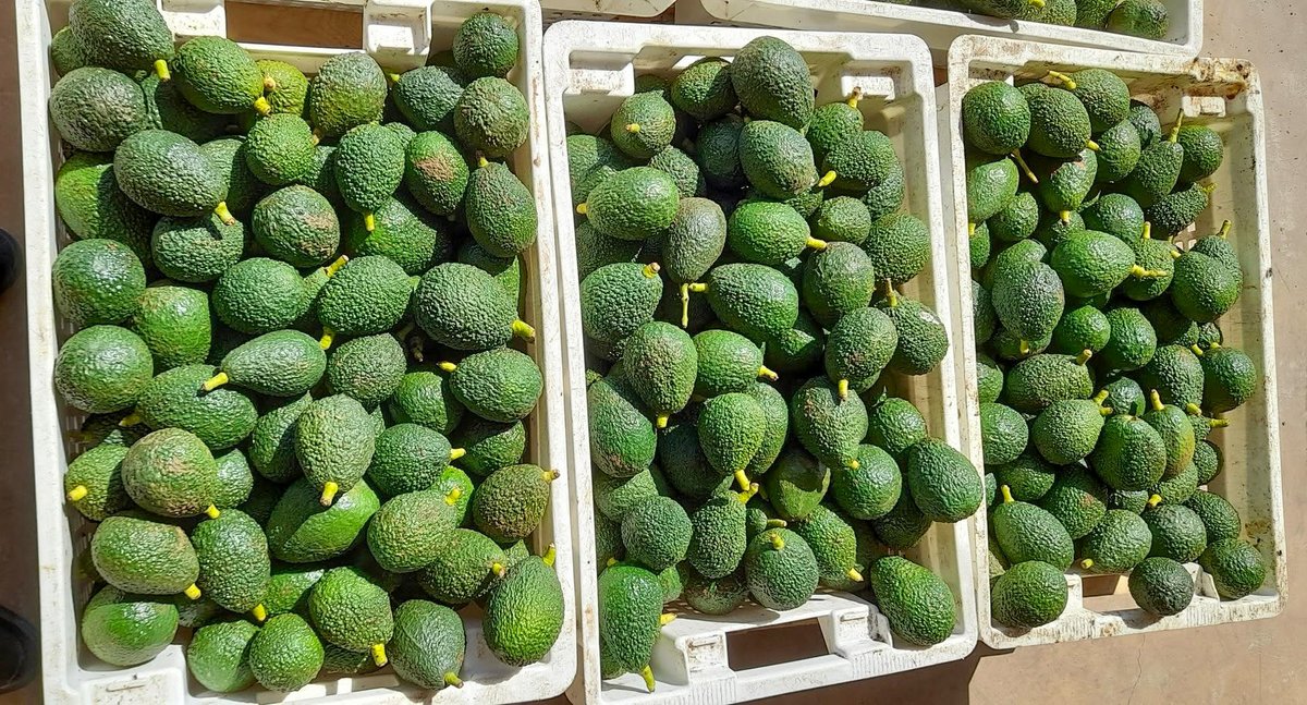
ኣቮካዶ ፍርያት ሃገርና !
The Eritrean Crops and Livestock Corporation (ECLC) is successfully harvesting avocados. At the Halhale Project now have over 10,000 avocado trees. They’re growing them together with coffee and olives, turning the land into productive farms.
@MezmurBest #Eritrea 🥑😋 🇪🇷
Ethiopia’s Interconnected Conflicts and Deepening Crisis of Legitimacy
By Alula Frezghi (@AlulaFre)
The emergence of renewed insurgent activity in Ethiopia’s Afar region is more than another localized security challenge. It is the latest indication that the federal government is confronting expanding armed resistance across multiple parts of the country. Rather than representing isolated security incidents, these developments point to a deeper structural crisis confronting the Ethiopian state.
From Oromia and Amhara to growing tensions in Afar and unresolved political divisions in Tigray, Ethiopia is increasingly defined by overlapping crises rather than isolated conflicts. Reports of defections to the Afar National Union Revolutionary Front (ANURF), also known as Uguugumo, suggest that Addis Ababa’s security challenges are becoming broader and increasingly difficult to contain.
Read More: https://t.co/eMZoqf4cpH
#Eritrea #Somalia #Djibouti #SouthSudan #Sudan #Ethiopia #Yemen #SaudiArabia📷
@BBCAfrica@BBCWorld@ReutersWorld@cnn_worldnews@blkagendareport@afpfr@AJEnglish@AljazeraAfrica@PMEthiopia@M_Farmaajo@MFAEthiopia@TheVillaSomalia@_AfricanUnion@UNGeneva