⛈️Was weather a factor in your case or insurance claim?
We provide forensic meteorology and weather consulting services to professionals in risk-focused industries—delivering clear, defensible answers when it matters most.
👉Follow us and visit https://t.co/cNnkF20c82 to learn more.
Rain is making a welcome return to Oklahoma this morning. 🌧️ A few strong to severe thunderstorms will also be possible, so be sure to keep an eye on the weather. #okwx
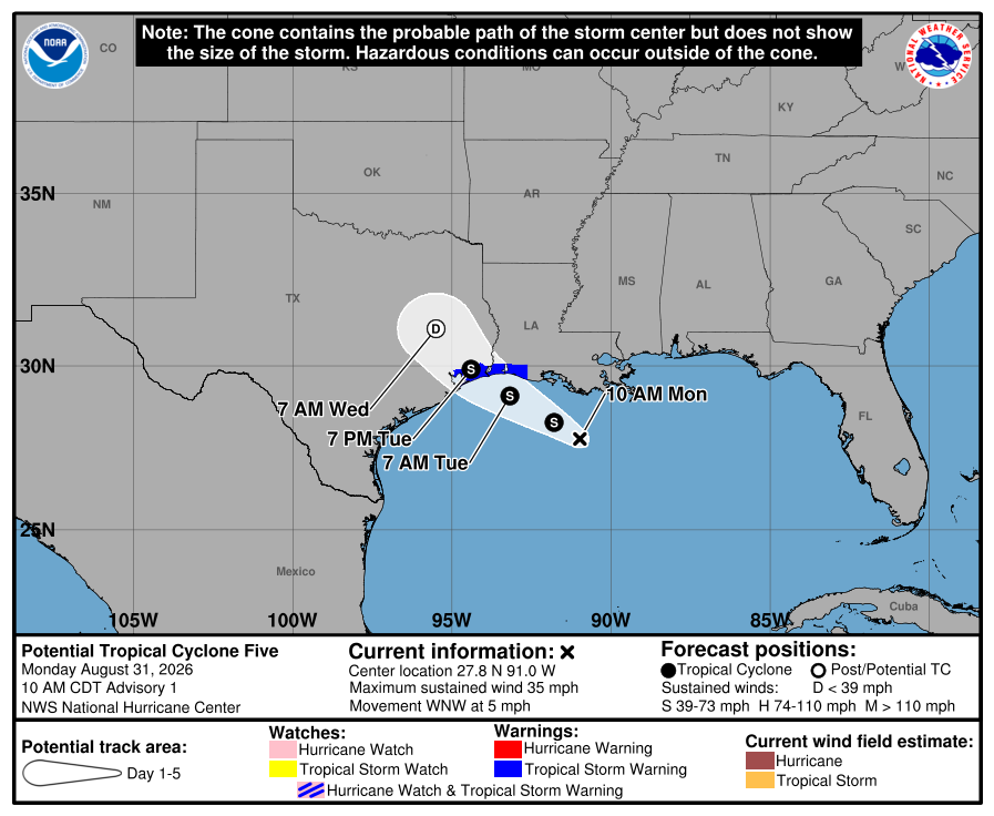
As of 10 AM CDT, AL97 has been designated Potential Tropical Cyclone Five. Tropical Storm Warnings are now in effect for portions of the northern Gulf Coast and adjacent inland areas as the system continues to organize over the Gulf of Mexico.
Above-average temperatures are favored across a good chunk of the country during the first week of September, while drier-than-normal conditions are expected across portions of the South and Great Lakes region.
Dangerous #heat continues across portions of the U.S. on Tuesday and Wednesday. Know the signs of heat exhaustion and heat stroke, and take action if symptoms develop.
Check out the graphic below for more information. Stay cool and stay hydrated!
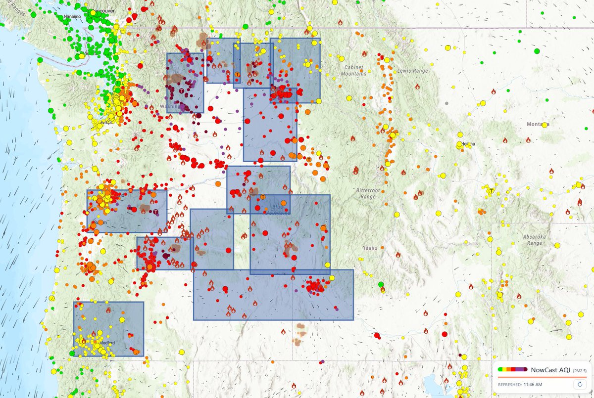
Smoke from #wildfires burning across the #PacificNorthwest has contributed to degraded air quality across the region.
Visit https://t.co/7gUfguDUoR for information and alerts in effect for your area, or https://t.co/0TLY1c0S6S to view current air quality conditions near you.
⛈️ Severe thunderstorms are likely tomorrow across portions of northern #NewEngland. All severe hazards are possible, including damaging winds, a few tornadoes, and large hail. ⛈️
Check out the latest Day 2 Convective Outlook below. ⬇️
On America's 250th birthday, numerous damaging wind gusts were reported across the central and eastern United States. Overall, 604 wind reports were received, with the peak gust of 92 mph recorded in Norman, Oklahoma.
If you are planning to celebrate America's 250th Birthday today, please stay weather-aware.
Today's severe weather risk includes the potential for widespread damaging wind gusts across portions of the Mid-Atlantic, including Washington, D.C., where some wind gusts may reach 75 mph.
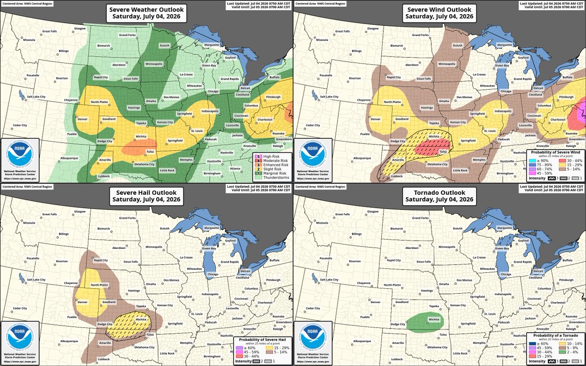
Additionally, significant outflow gusts exceeding 75 mph, large to very large hail, and isolated tornadoes are possible across portions of northern Oklahoma and southern Kansas. Be sure to have multiple ways to receive weather-related information and stay safe! #USA #4thofJuly #SevereWeather
We're monitoring the severe weather situation across North Texas, where very large to giant hail (3-4+ inches) is expected today. The latest outlook from the Storm Prediction Center puts the DFW metro area inside a 45% CIG2 hatch risk for large hail today. Additionally, these storms will pose a risk of a few tornadoes (some strong) and damaging wind gusts (some hurricane-force or greater). A recent mesoscale discussion highlights a forthcoming tornado watch to address this situation. Stay weather aware today! #txwx
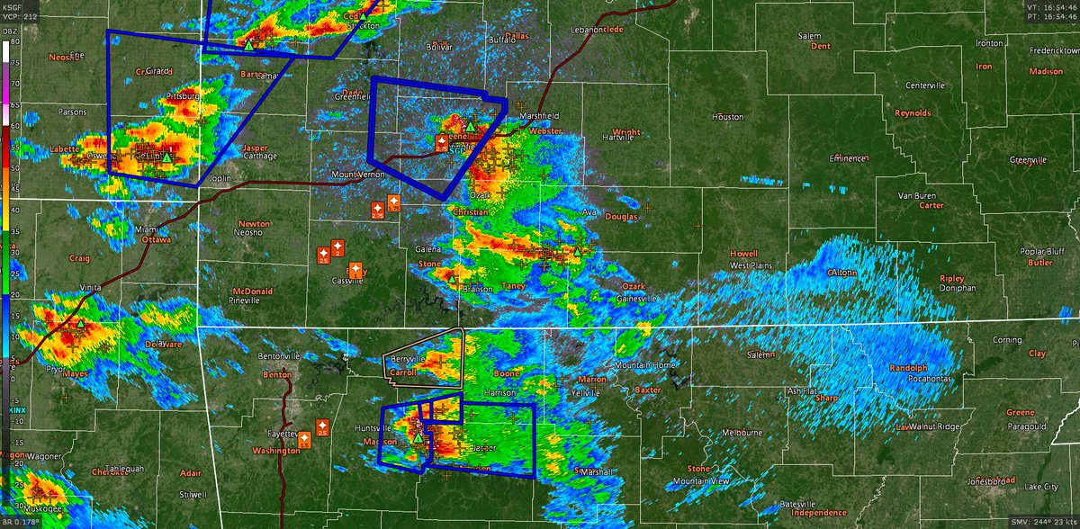
We’re currently monitoring severe thunderstorms across northern Arkansas and southern Missouri this morning, where several reports of very large hail have been received. Ensure you have multiple ways to get weather-related information, and take immediate action if a warning is issued for your area. #mowx #arwx
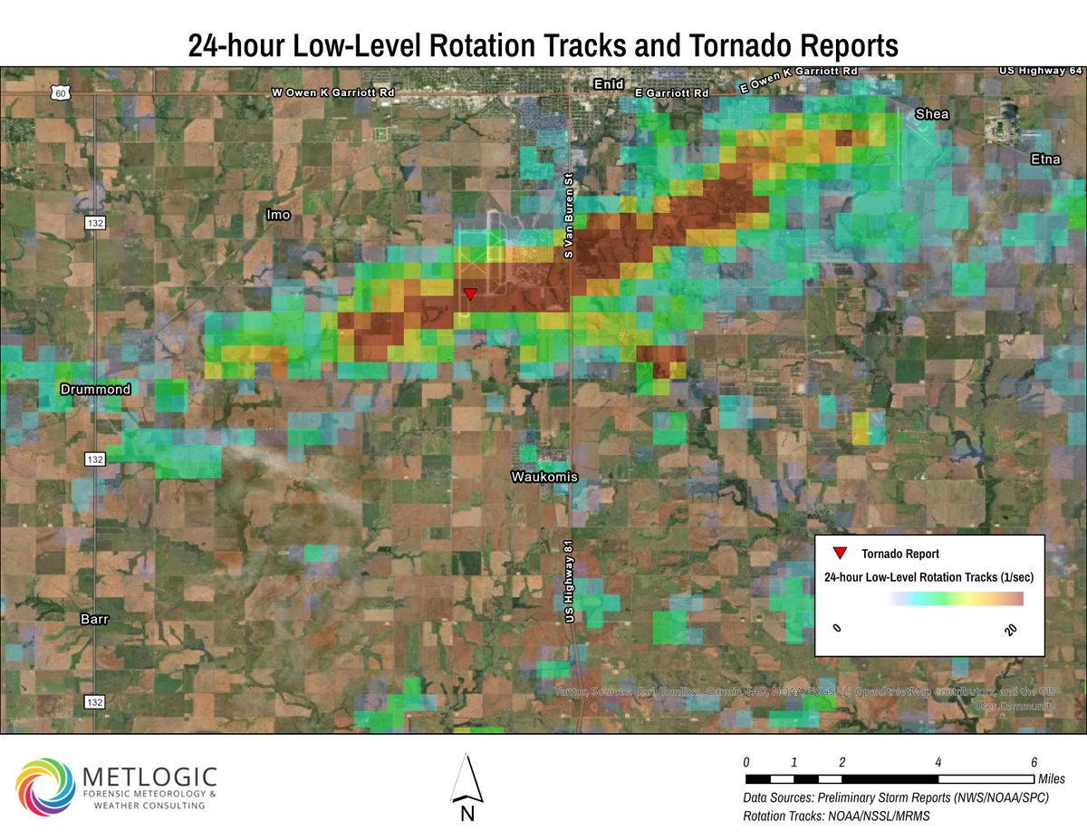
These reports include a couple of intense tornadoes in northern Oklahoma. Here’s a look at one of those events using 24-hour low-level rotation track data from MRMS, which highlights a swath of stronger rotation associated with a tornado that impacted Vance Air Force Base and Enid, Oklahoma. #okwx (2/2)
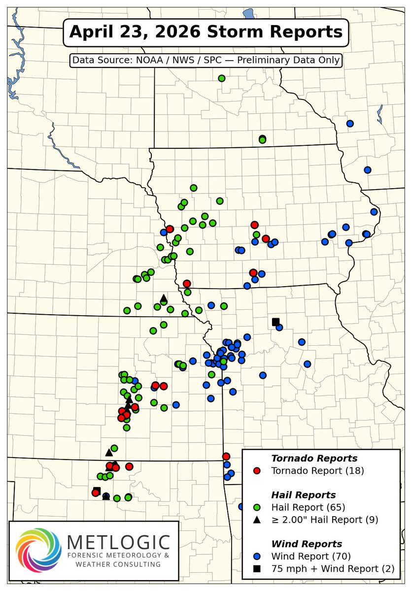
Preliminary storm reports from yesterday indicate that severe thunderstorms produced several tornadoes, along with numerous instances of large hail and damaging wind gusts stretching from the Southern Plains into the Midwest. (1/2)
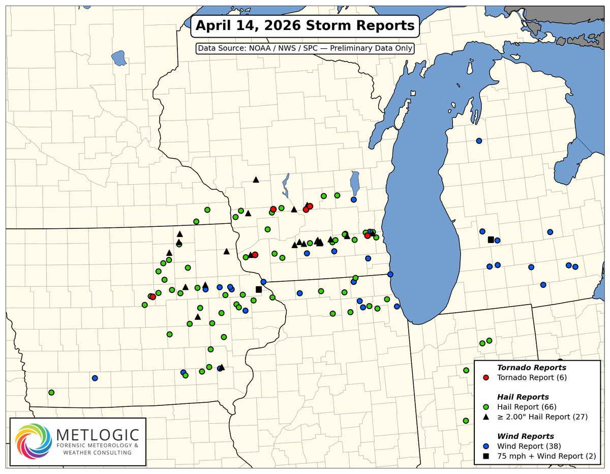
Numerous reports of large to very large hail, along with a few damaging wind gusts and tornadoes, occurred yesterday across portions of eastern Iowa and southern Wisconsin. Check out the map below for the preliminary reports received so far.
#iawx#wiwx#ilwx#severeweather #forensicmeteorology #insurance
A focused corridor of severe weather developed across eastern Kansas and western Missouri yesterday. A couple of cyclic supercells across Kansas produced several tornadoes, scattered large hail (including reports of hail 2 inches or more in diameter), and damaging wind gusts. Additional instances of isolated large hail and scattered damaging wind reports extended eastward across Missouri.
If severe weather impacted your area and you need a comprehensive, site-specific forensic weather analysis, contact us today.
#kswx #mowx #severeweather #forensicmeteorology #insurance
Severe thunderstorms produced widespread reports of large to very large hail, scattered damaging wind gusts, and several tornadoes across portions of the Upper Midwest yesterday. A map of storm reports is shown below.
If severe weather impacted your area and you need a comprehensive, site-specific forensic weather analysis, contact us today.
#mnwx #sdwx #iawx #wiwx #severeweather #forensicmeteorology #insurance
Starting this Saturday, an active multi-day period of #severe weather appears possible. If you are in or around any of the highlighted areas, be sure to monitor the latest forecast as we approach the weekend.
On Friday, April 3, 2026, a concentrated corridor of severe weather developed from the Oklahoma City metro eastward, with intense damaging wind gusts up to 80 mph and a few tornadoes.
While storm reports are an excellent starting point, they may not fully capture the conditions experienced at all locations along a storm’s path. If you experienced severe weather and require a comprehensive forensic analysis, contact us today.
#okwx #txwx #severeweather #forensicmeteorology #insurance
Severe thunderstorms capable of producing all #severe hazards are likely today across portions of the Southern and Central Plains. Check out the latest Day 1 Convective Outlook graphics below.⬇️
#okwx#kswx#txwx