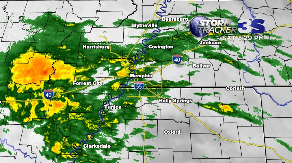
A wet night is on tap for the mid south with rain not stopping until mid day tomorrow. Rain may be heavy at times with up to 2" of total QPF is possible. No severe weather is expected but excessive rainfall is possible especially in eastern Arkansas. You might even hear a rumble.
Much needed rain has moved into the mid south and will be with us the rest of the night through tomorrow morning. A good Valentine's night to spend inside, but if you are going out have that umbrella handy.
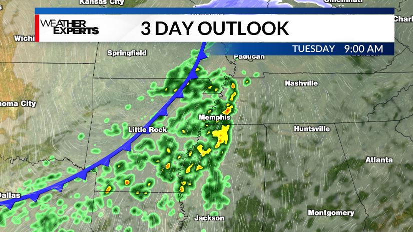
GOOD NEWS! High temps warm to well above freezing this week with the chance of rain Tuesday. This should melt away most of the snow and ice by mid week. It looks like we've finally broken the pattern of arctic temperatures for the foreseeable future.
REBALERT: The Oxford campus at the University of Mississippi will be closed through Sunday, Feb. 8, due to the extreme impact and ongoing recovery efforts from the recent ice storm and severe winter weather.
This includes the cancellation of all classes, events and activities. The university will continue to evaluate conditions and will notify the campus community of any further necessary adjustments to operations.
The university, city and county have experienced significant impacts from the ice storm including downed trees and power lines, power outages, falling ice and hazardous road conditions.
• For those currently in the area who decide to travel: Please check weather and road conditions along your route and make travel decisions accordingly. Some roads in the region are currently shut down. The Mississippi Department of Transportation has free resources related to road conditions, weather and more.
• For those not on campus or not in the local area: Do not return at this time in order to provide our first responders and university teams the ability to safely undertake recovery efforts.
Work continues to reinstate basic services such as power and water, clear roads and walkways, remove trees and debris, and assess and address ongoing impacts to buildings and campus infrastructure.
All classes and academic activities are cancelled until the university reopens. Once reopened, faculty and instructors will communicate directly with students regarding adjustments to coursework, academic activities, assignments, exams and deadlines. Additional details and information will be shared by the Office of the Provost.
The Student Union continues to serve as a warming center for students and employees, with overnight access. The Rebel Market continues to serve as our food service location for this event.
OUT buses have resumed limited operations with service from the majority of the Master Lease locations to the Student Union and to Walmart, 8 a.m.–3:30 p.m. on a continuous loop. Follow @outransit on Twitter and Instagram for schedule updates.
Regional campuses make decisions about changing operating hours in conjunction with their host campuses. Check regional campus websites for any changes or updates to operating schedules.
FREEZING FOG - Calm winds, and abundant low-level moisture enhanced by the snow/ice pack will be a perfect setup for fog development the next couple of nights. With temperatures well below freezing, that means freezing fog.
No, this doesn't lead to heavy ice accumulation, but it does lead to more slick spots on the roads. That combined with already hazardous travel and low visibility means you need to be giving yourself a lot of extra time in the morning if you're heading out. Expect a similar setup for early Thursday as well.
Ice is becoming an increasing issue in Oxford as freezing rain falls. The disruptions will get worse with round 2 tonight through part of tomorrow #mswx
Heavy snow a few moments ago in Poinsett county. Sleet is mixing in at the moment. As you go farther south more sleet will be mixed in, and north Mississippi has the greatest risk of freezing rain. Tune into @3onyourside for ongoing coverage
in some places. Prepare for extended power outages in the southern part of our viewing area. Farther north will be much more snow, with over a foot possible in places. Because we're in the transition line, minor changes to the forecast are possible.
Near the I-40 coridoor including the Memphis metro expect lots of sleet, some freezing rain and at least a few inches of snow. Farther south will be mainly sleet and freezing rain. This is where the greatest ice accumulations are expected. Travel may become virtually imposible 1/
3pm Friday: Our winter storm moves in tonight.
Many areas along and north of I-40 will start as snow and stay snow for several hours into Saturday morning before changing over to sleet and freezing rain. This initial snow will amount to a few inches many areas (more the further north you go). Once the sleet moves in, it will start compacting down the snow. Some changeover back to snow on Sunday morning could add another inch or two. Bottom line, if you're far northwest, you get more snow and less sleet. If you're farther southeast, you get mainly sleet and freezing rain. In between you get a mix of all three to varying degrees. We all have major impacts, but some areas will be worse than others, especially where freezing rain (ice) is abundant.
Power outages will be most widespread in areas with more ice. This is going to quite hazardous, not only over the weekend with temps staying well below freezing, but especially early next week. Sunday night we are all within a few degrees of 0° and wind chills will range from -10 to -20 in many areas Monday morning.
We'll be here for you with updates and extended coverage throughout the weekend. Stay safe, and remember to check in on your neighbors, family, and friends!