A steamy Monday ahead with peak heat index values up around 100°. Any scattered storms that get going this afternoon/evening will be capable of producing damaging winds and/or hail. Keep an eye on your WREG radar app as you’re out and about!
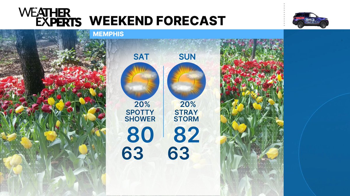
Hope you have some plans lined up with mom this weekend! If you're trying to do anything outside, Saturday is going to be our better day. Periodic showers and storms on Sunday as our next cold front moves through, but it should be a bit drier by Sunday evening.
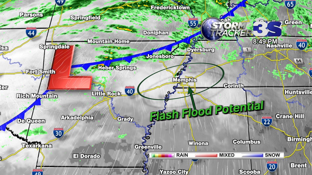
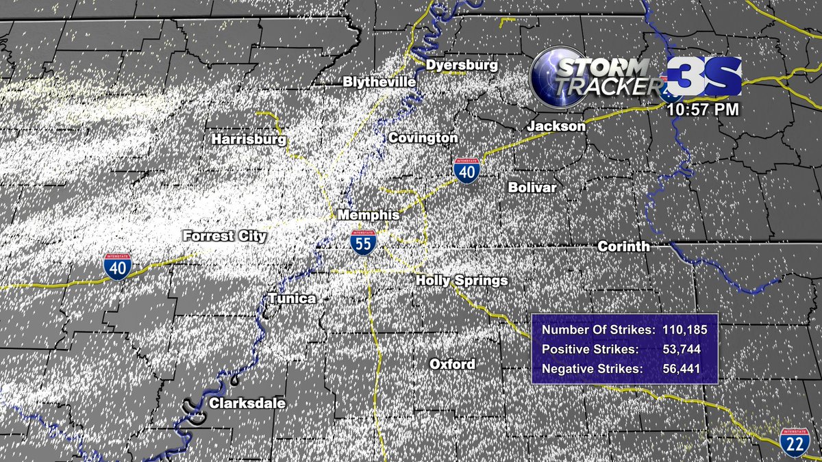
Severe threat is still going to be there through the overnight hours as storms slowly drift southeastward across the I-40 corridor and eventually into north Mississippi, but as I've said, it's not an overly concerning setup. Things are however trending in a way that will allow for slow-moving storms to produce heavy rainfall. With the 1-3" that already fell around Memphis and Shelby Co. this morning, this is likely to lead to localized flash flooding. Additional periods of heavy rain on Wednesday could aggravate any ongoing issues as well.
Tuesday night storms... here's a look at general arrival times. Hail and wind still the primary threats, but a brief spinup tornado is possible. Totally fine to head to bed tonight, just make sure you have a way to receive any warnings.
Active weather on tap for Tuesday and Wednesday.
Expect some fading downpours mainly north of I-40 through the morning hours of Tuesday, but the afternoon will be mainly dry. There will be very little, if any, severe threat in the morning.
An approaching cold front will fire up scattered storms across Arkansas and southern Missouri by early Tuesday evening. Those storms will slowly drift across the MS River late in the evening and overnight. These will primarily have a hail and wind threat, but a tornado or two is also possible - especially in Arkansas.
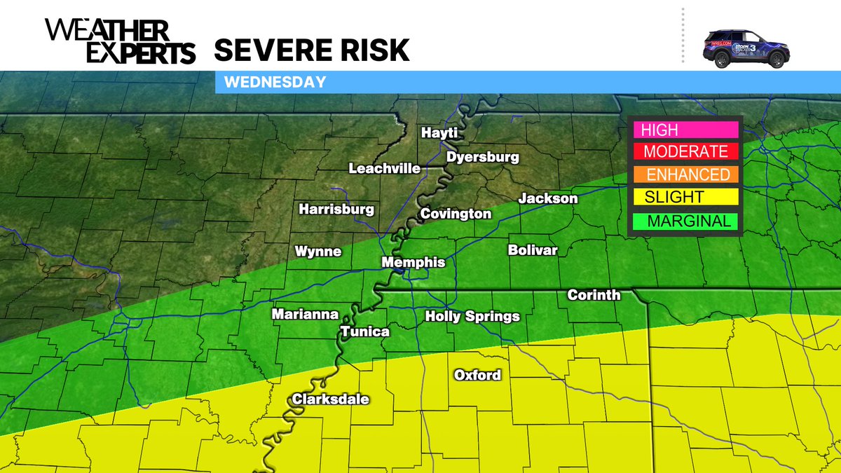
On Wednesday, the front shifts south of I-40, and any threat for severe storms will shift south as well.
Our severe threat for the rest of the day has diminished quite a bit thanks to the afternoon round of storms. While a strong storm or two is still possible, the primary issue will be additional heavy rain and flash flooding.
Many spots have already picked up 2-4″+ of rain since Monday evening, and another 1-3″ is possible through late this evening. This will likely lead to flash flooding, especially in low lying areas.
Textbook mammatus clouds in Brighton, TN in the wake of Tuesday afternoon’s storms. These typically form in a turbulent atmosphere. It’s the only type of cloud that forms from sinking air rather than rising.
Photo: @MadMaxClaypool
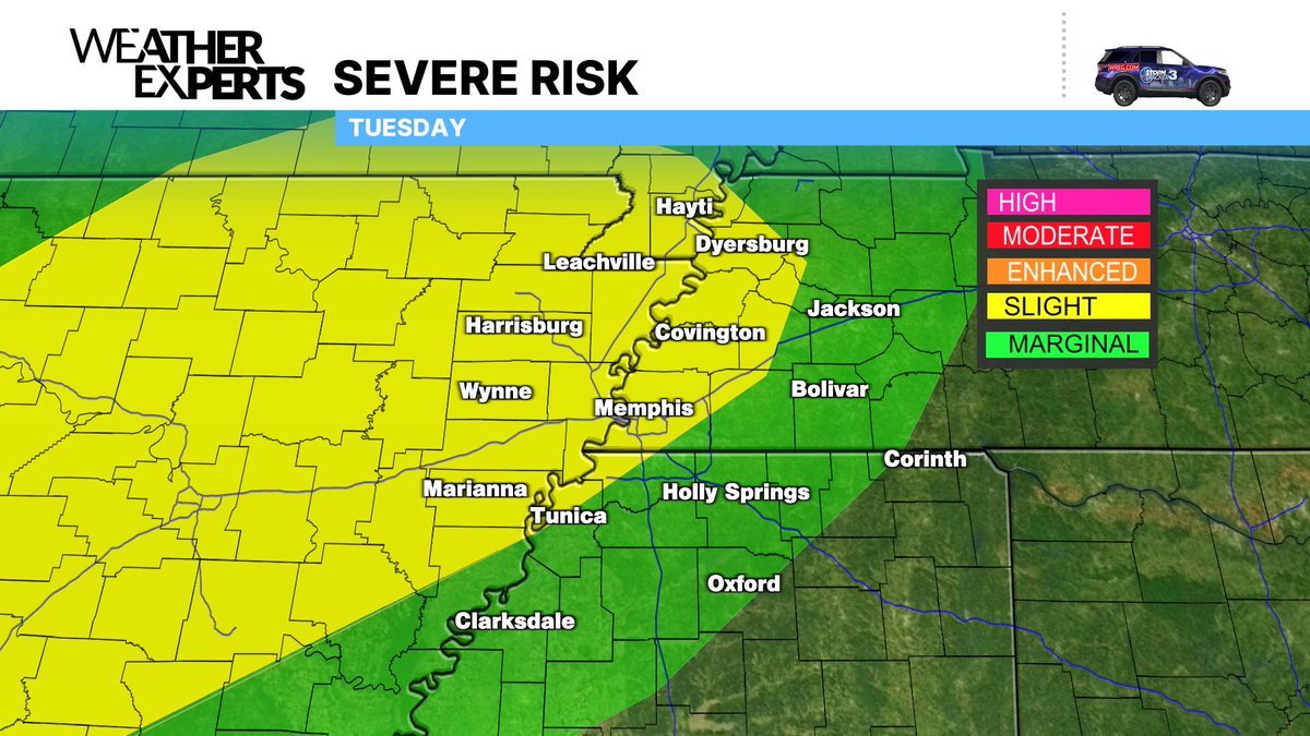
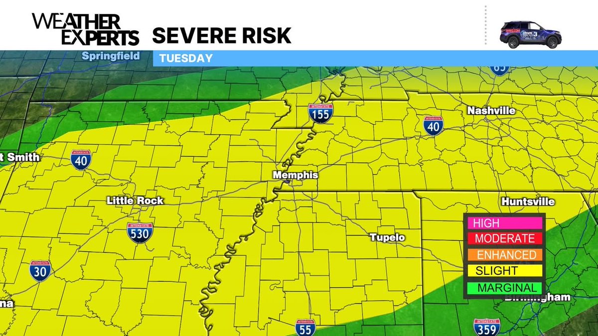
Tuesday Severe Threat: Different setup today, but a severe threat nonetheless. Scattered storms will fire up this afternoon and move west to east. Mainly damaging wind and hail issues. A few tornadoes are possible, but it’ll more so be dependent on storm mode and small scale boundary interactions.
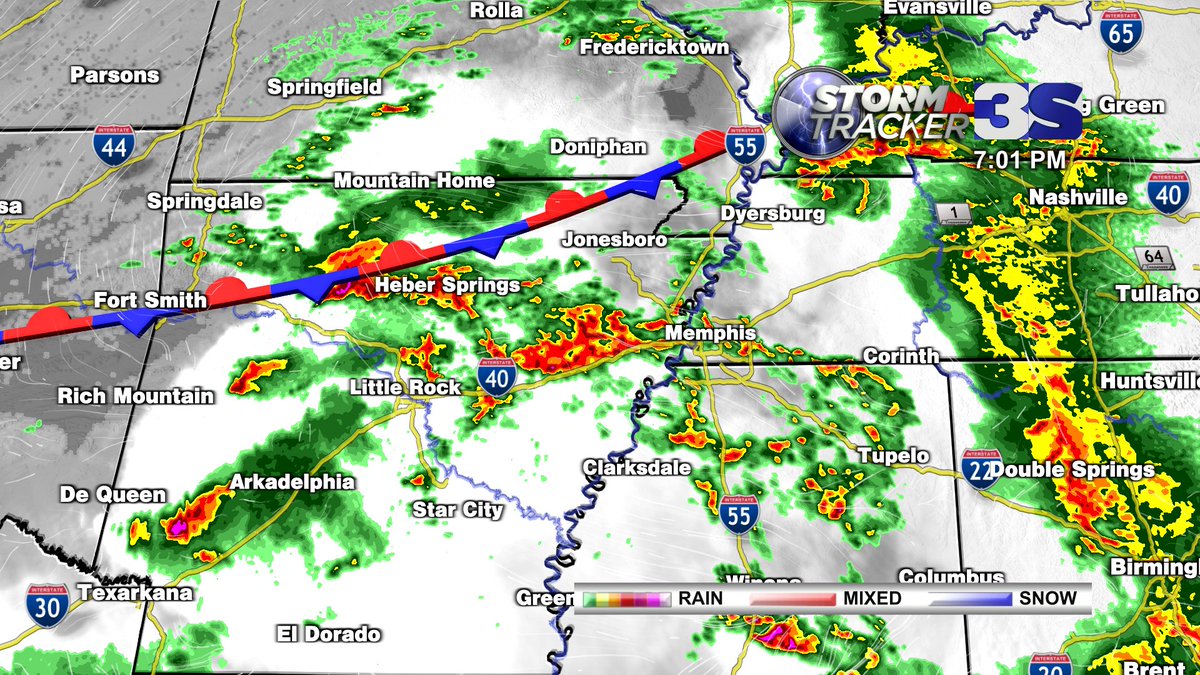
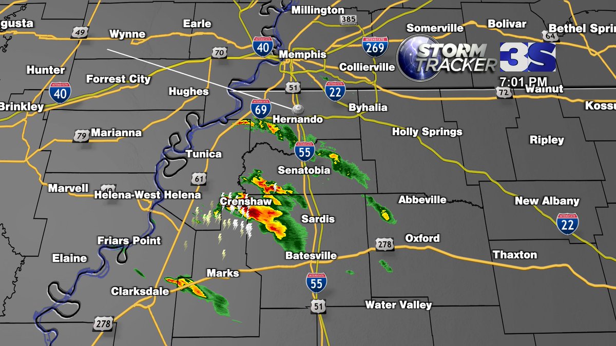
7:03PM Monday: Initial cell development this evening has been through far NW Mississippi. Keeping a close eye on these as they lift northeast. As I write this, everything is below severe limits, but that may change over the next hour or so.
Tornado watch out now for many of us through the evening. This is a PDS (Particularly Dangerous Situation) Watch due to the elevated severity of impacts where severe storms do occur. Damaging wind gusts up to 70 mph, hail up to 2.5" in diameter, and potential for any tornadoes to be EF2+. We have you covered all the way through!
Two separate severe threats for us early this week...
MONDAY NIGHT: Timing is roughly going to be 10pm Monday to 4am Tuesday. It still appears as though the highest threat will be just north of us, but storms locally will still have a high wind and hail threat. A tornado or two is also possible, especially if some individual cells are able to develop. Not everyone is going to get severe weather, in fact, not everyone will even get storms. We'll be staffed through the night keeping an eye on things. The best thing you can do with a nighttime threat is simply have a way to receive warnings, particularly one that will wake you up.
TUESDAY: Storms from overnight will be waning and clearing out by sunrise. As we destabilize again Tuesday afternoon, and the front lingers just north of us, scattered storms will likely fire again. Whether that happens by mid-afternoon, or holds off until the evening isn't set in stone just yet, but these storms will also have the threat for all modes of severe weather. For now, the SPC has the entire area in a slight risk for Tuesday, but I wouldn't be surprised if that gets upgraded at some point.
It's been a little while since we've had any meaningful threat around here, but it is late April... we would expect this from time to time. Don't worry, we'll get through it together as we always do. I'll keep you posted.
A quieter weekend on tap before things get active again next week. Late Monday evening into Monday night the ingredients are there for a more widespread severe weather threat, but as it stands right now, the highest threat will likely be just north of the News Channel 3 viewing area. The exact timing, and what threats will be most prevalent, will become more clear in the coming days. We’ll keep you posted!
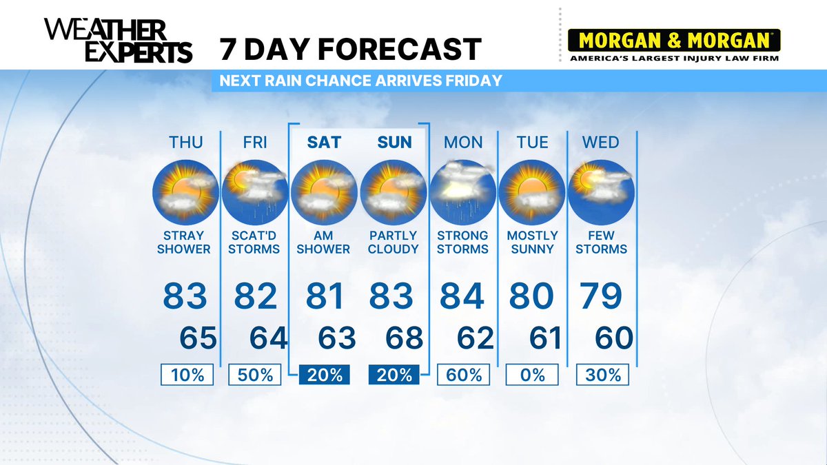
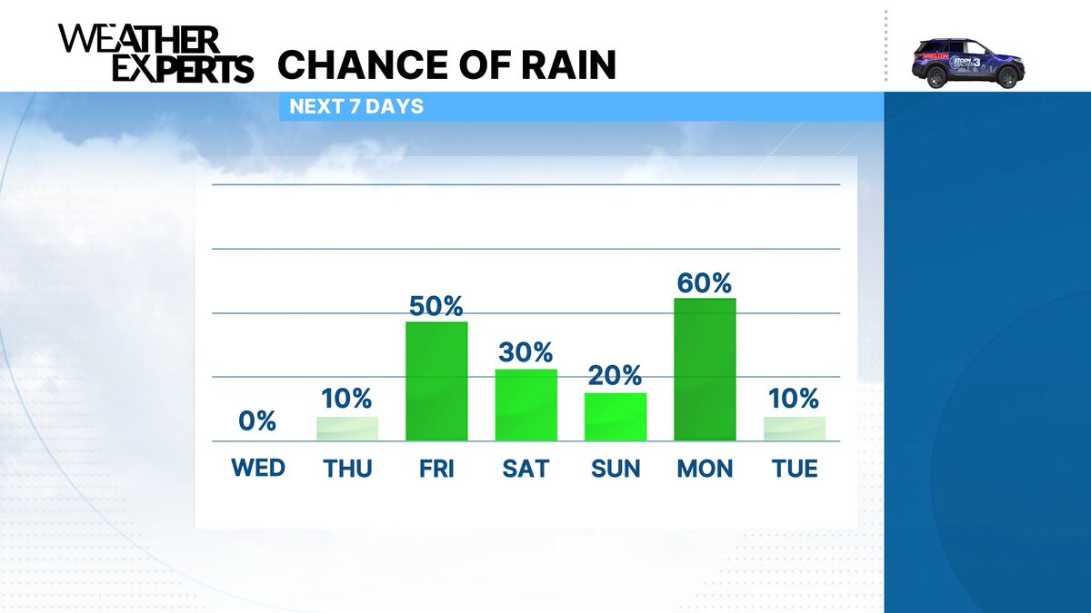
Another really nice day on Thursday before things get a bit more active around here. Still not overly concerned with Friday's severe risk. A few storms may briefly produce damaging winds and/or hail, but it won't be widespread - more so just thankful for the scattered downpours we really need... 'scattered' being the key word though, some folks won't get much.
Monday is the day I'm watching for the potential of more widespread severe weather. The ingredients will definitely be there, but exactly where the biggest threat will set up isn't nailed down just yet. For now, don't get too worked up about it, this is still several day away. We'll have pretty good weather over the weekend, so make some plans to enjoy some time outside and we'll keep you posted on Monday as things become more clear.
Great to have some more shots at meaningful rain in the forecast over the next week, but at times it will come with severe weather potential. Friday's system won't have much, if any, severe weather threat locally, but Monday is a setup that we'll need to pay attention too. No cause for concern now, just an early heads up.