Dedicated to providing reliable emergency communications for GMRS operators in the Middle Tennessee area during severe weather or other emergency activations
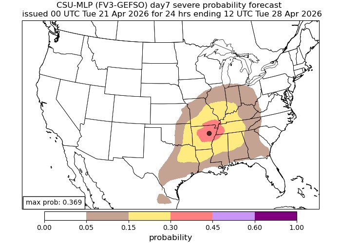
New run from the updated CSU map for Monday. A 30 % Severe Probability has been added for portions of Middle Tennessee including a hatched area. This is showing a probability of severe weather not the individual threats.
Is severe weather possible on Monday? Yes! Do we know the time and specific threats at this time? Not as of yet and things can and most likely will change.
I’ll provide updates accordingly #tnwx
I’m definitely keeping an eye on Monday April 27. The Storm Prediction Center this morning highlighted Middle Tennessee under a 15% probability of severe weather
CSU has also highlighted a probability of 15 % across Middle Tennessee. A 30% probability for severe weather has also been highlighted for portions of West Tennessee.
Timing and threats are uncertain at this time. I’ll be monitoring trends and providing updates accordingly. #tnwx
The Storm Prediction Center has highlighted Middle Tennessee under a Day 7 risk for severe weather. Timing and certain threats are unknown at this time. #tnwx
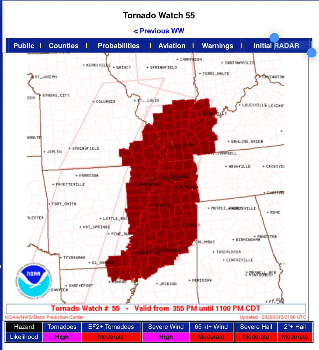
The Storm Prediction Center has issued a #tornadowatch for the following West Tennessee counties until 11PM CDT #tnwx
BENTON
CARROLL
CHESTER
CROCKETT
DECATUR
DYER
FAYETTE
GIBSON
HARDEMAN
HARDIN
HAYWOOD
HENDERSON
HENRY
LAKE
LAUDERDALE
MADISON
MCNAIRY
OBION
SHELBY
TIPTON
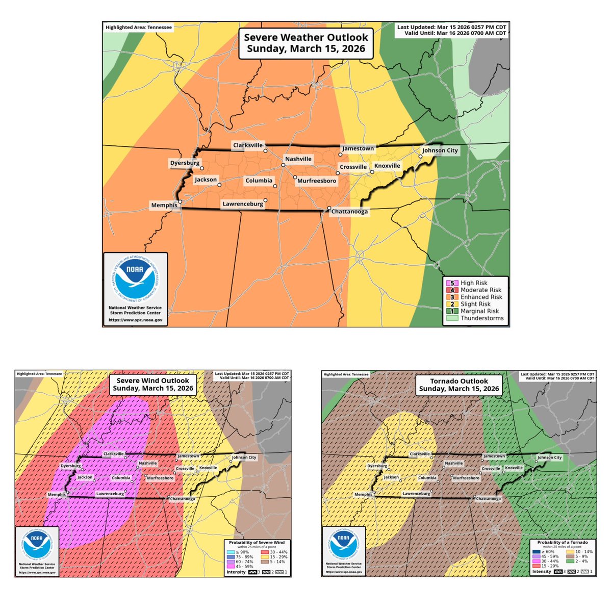
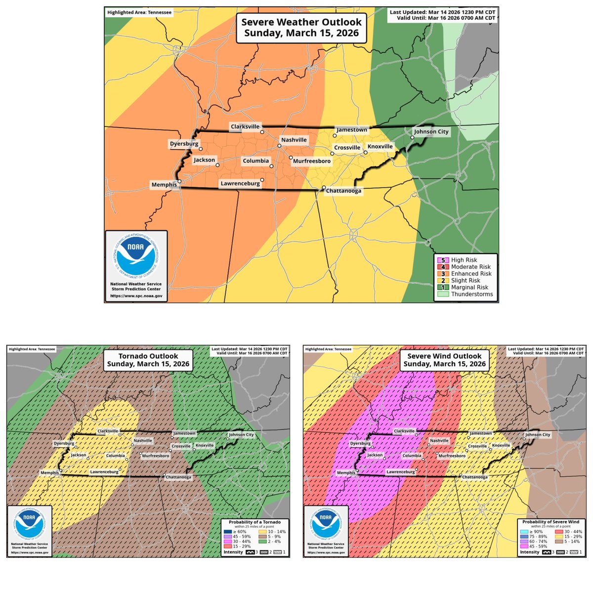
3:00 PM update The Storm Prediction Center continues the Enhanced Risk level (3/5) for all of Middle Tennessee.
The 45% CIG 1 Damaging wind risk has also shifted a bit east to include Clarksville, Nashville, Columbia, and Lawrenceburg.
As for the Tornado Risk for most of Middle Tennessee we are under a 5% CIG 1. As for Clarksville, yall are under a 10% CIG 1 risk for this evening.
Stay Wx aware this evening and take each warning seriously! #tnwx
12PM update. The Storm Prediction Center keeps most of Middle Tennessee under a Enhanced Risk level (3/5) for Sunday March 15. They also introduced a 10% CIG 1 which includes Clarksville, Nashville, Columbia, Lawrenceburg. The damaging wind threat also also increased for portions of Middle Tennessee which includes Clarksville in a 45% CIG 1 for severe winds.
#tnwx
The Storm Prediction Center has extended the Enhanced Risk level (3/5) to include most of Middle Tennessee. Includes Clarksville, Nashville, Murfreesboro, Columbia and Lawrenceburg. They also introduced a 30% CIG 1 severe probability outlook with the new Enhanced Risk upgrade. #tnwx
Looked into some new data rolling in this AM. Top graphic is the CSU/SPC Day 3 comparison and bottom is the NSSLsevere probability. A severe weather scenario looks to still be possible across Middle Tennessee Sunday evening into overnight.
More updates to come shortly #tnwx
The Storm Prediction Center has Middle Tennessee highlighted under a Slight risk level (2/5) for Sunday March 15.
They have also introduced a CIG 1 within the slight risk area with a 15% probability of severe weather. #tnwx
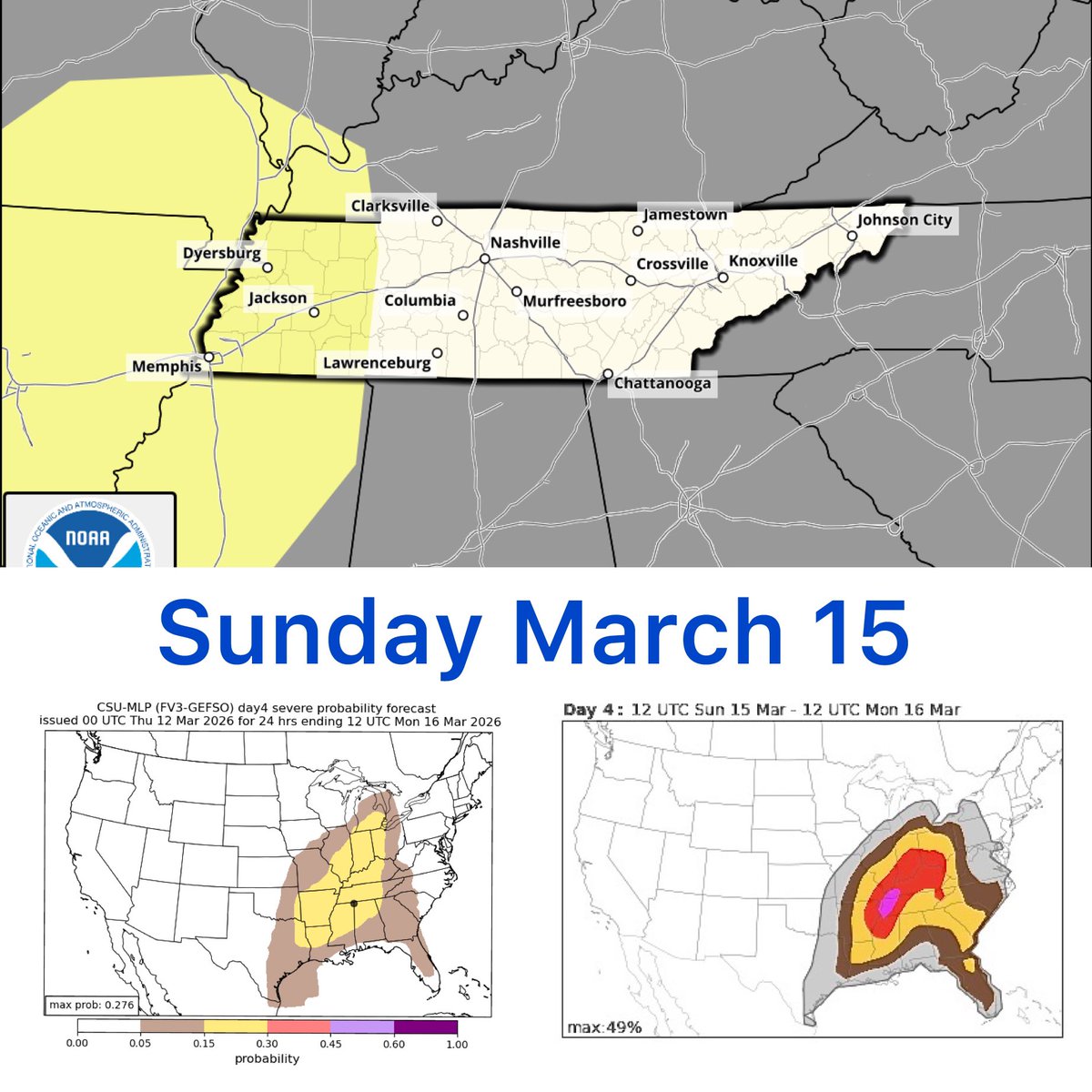
We are monitoring the possibility of severe weather for Sunday March 15. As of right now the Storm Prediction Center doesn’t have middle Tennessee highlighted in the Day 4 outlook.
The second graphic is the CSU which has highlighted a Day 4 Severe probability forecast which has Middle Tennessee highlighted.
The NCAR convective hazard forecast has also got us highlighted too. With this model I usually take it by a grain of salt.
This is still several days out and thing will most likely change. But it’s a good idea to watch this and see how it plays out.
I’ll provide updates as they come accordingly #tnwx
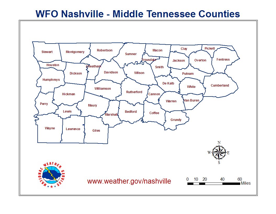
At any time of the year it’s a good idea to familiarize yourself with the counties in Middle Tennessee in case a warning is issued for your area. #tnwx
•Bedford
•Cannon
•Cheatham
•Clay
•Coffee
•Davidson
•DeKalb
•Dickson
•Fentress
•Franklin
•Giles
•Grundy
•Hickman
•Houston
•Humphreys
•Jackson
•Lawrence
•Lewis
•Lincoln
•Macon
•Marshall
•Maury
•Montgomery
•Moore
•Overton
•Perry
•Pickett
•Putnam
•Robertson
•Rutherford
•Sequatchie
•Smith
•Stewart
•Sumner
•Trousdale
•Van Buren
•Warren
•Wayne
•White
•Williamson
•Wilson
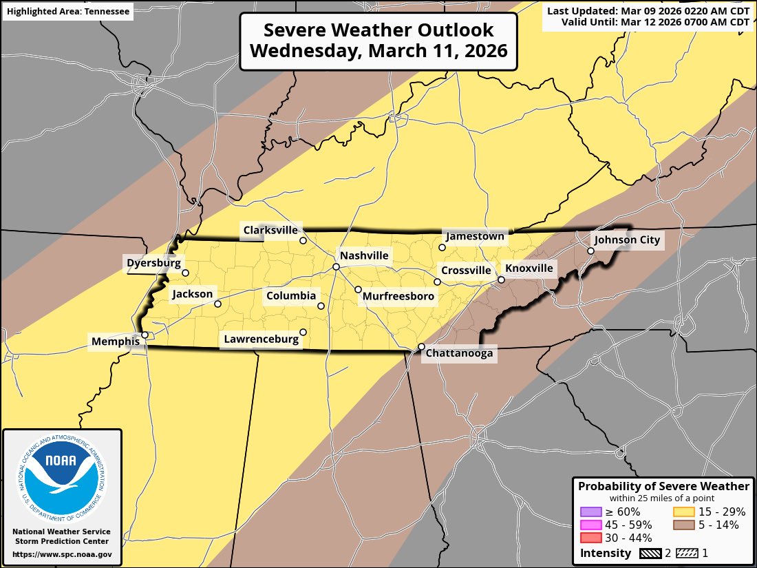
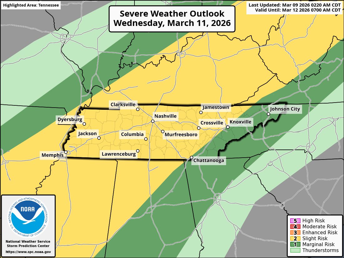
The Storm Prediction Center continues to have Middle Tennessee highlighted under a Slight Risk level (2/5) for Wednesday March 11. A 15% probability of severe weather also exists with the day 3 outlook.
Stay weather aware! #tnwx
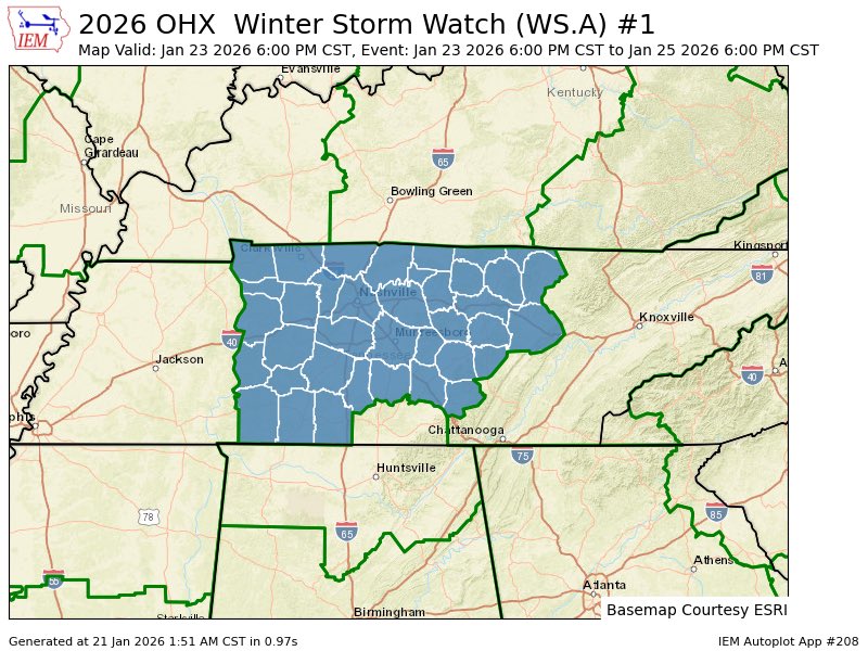
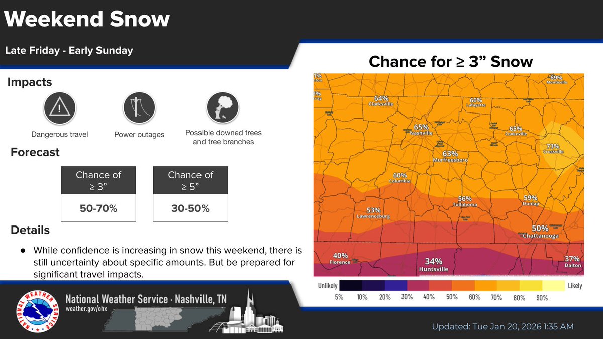
A significant winter storm is forecast to impact much of Tennessee this weekend (starting late Friday into Saturday and Sunday, January 24-25, 2026), with potential for several inches of snow (higher chances in Middle and parts of East Tennessee), possible ice accumulations (especially south of 1-40 in some areas), hazardous travel conditions, bitterly cold temperatures (highs in the 20s), and risks of power outages from ice or downed lines. Forecasts still have some uncertainty in exact totals and track, but preparation is key-especially for possible extended power loss or being stuck at home.
Here are practical emergency preparedness tips tailored for this event, drawing from National Weather Service,
• Food: Non-perishable items that require no cooking (or minimal if you have backup heat).
Stock:
• Canned goods (soups, fruits, veggies, meats like tuna/chicken)
• Energy bars, peanut butter, crackers, nuts, dried fruits
• Ready-to-eat meals, cereal, powdered milk
• Manual can opener
• High-calorie foods for energy in cold
• Water: At least 1 gallon per person per day for drinking and sanitation (3+ days minimum). Store bottled water or fill clean containers. If pipes freeze/burst, you'll need this.
Backup Power and Batteries:
• Extra batteries (AA, AAA, D) for flashlights, radios, and devices.
• Portable power banks or solar chargers for phones.
• Backup batteries or a portable power station (e.g., for charging essentials or small appliances).
• Avoid using generators indoors-use only outside, far from windows/doors to prevent carbon monoxide poisoning. Test any generator now.
• Flashlights, lanterns, and headlamps (with extras).
• Communication Tools:
• NOAA Weather Radio (battery-powered or hand-crank) for official alerts.
• Battery-powered or hand-crank AM/FM radio for news.
• Ham radio (amateur radio): If licensed, great for long-range emergency comms when cell networks fail. Know local repeaters, ARES/ RACES groups in Tennessee, and frequencies (e.g., 2m/70cm bands). Have it preprogrammed and tested.
• GMRS radios (General Mobile Radio Service):
Family-friendly for short-range (up to a few miles) comms—no license test needed (just
FCC registration for GMRS). Handheld units like Midland or Motorola are popular; useful for checking on neighbors/family if phones are down.
Charge them and have spares.
• Cell phone + car charger + backup battery.
• Other Essentials:
• First-aid kit (include cold-weather items like hand warmers).
• Blankets, sleeping bags, extra warm clothes (layers: wool/synthetics).
• Medications (extra supply), baby/pet needs.
• Sanitation: Trash bags, toilet paper, hand sanitizer, bleach for water purification.
• Cash (small bills), important documents in waterproof bag.
• Fire extinguisher, matches/lighter (in waterproof container).
Home Preparedness
• Insulate pipes (wrap with foam or towels) and let faucets drip to prevent freezing.
• Stock heating fuel (if using alternative sources like wood/propane).
• Test smoke/CO detectors (with battery backups).
• Charge devices fully and have ways to stay warm if power goes out (layer up, close off unused rooms, use safe alternatives like hot water bottles
—never use grills/ovens indoors).
• Clear gutters/drains if possible.
If You Must Travel (Avoid if Possible)
• Keep gas tank full.
• Car kit: Blankets, extra clothes, food/water, shovel, ice scraper, sand/cat litter for traction, jumper cables, flashlight, flares, first-aid.
• Drive slow, increase following distance, avoid sudden moves.
• Tell someone your route/plans.
Staying Informed and Connected
• Monitor NWS Nashville (https://t.co/RrfGmIAGCR) or local outlets for updates.
• Use ham/GMRS for neighborhood checks if isolated.
• Check on elderly/neighbors.
Stay safe-prep today so you can hunker down comfortably. If conditions worsen, follow local emergency management (TEMA) guidance. This storm could bring travel chaos and outages, so better to be overprepared #tn
A potential winter storm is possible across Tennessee this weekend. Here’s the newest 12z Euro. Will this be an impactful event? Not sure. But it has the *potential* BUT this needs to be monitored carefully
#tnwx