Kansas, this PDS Tornado Watch means you need to be ready for anything. Have your plan, know your safe spot, and stay weather-aware until 8 PM CDT tonight.
If the Second Amendment does not apply to this exact kind of moment, what do people think it is for?
A citizen can lawfully carry, see masked federal agents beating someone in public, move toward the scene to help, and then get erased with a hail of bullets because “he had a gun.”
That excuse is an insult in a country where possession is legal by design, where the whole point is that the public never becomes a disarmed audience watching state power operate with impunity.
I’m not interested in arguing frame-by-frame footage. I’m interested in the principle that a free people cannot accept a standard where lawful carry becomes a death sentence the second authority feels threatened.
If that is the standard, then the 2nd Amendment has been reduced to a vibe. The founders did not write it so Republicans could do militia cosplay on weekends.
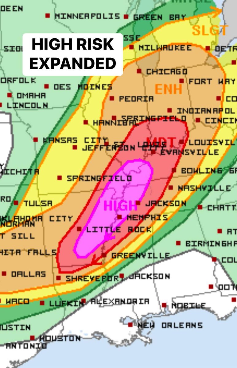
HIGH RISK expanded south through much of eastern Arkansas back to nearly Little Rock!
Tornado outbreak expected today including multiple EF3+ tornadoes. Memphis to Paducah included.
This is the real deal folks. Stay tuned to severe weather watches and warnings and have a family severe weather plan ready to go in this entire massive warm sector.
These next two days are going to be a big deal across the central/eastern U.S.
Be sure to stay tuned to severe weather warnings and have a well-rehearsed severe weather safety plan ready to go
Yesterday was such a sad day for many of our friends of Nebraska and Iowa, with horrific damage in communities like Lincoln, Elkhorn, Council Bluffs, and Minden. Other damaging tornadoes happened across parts of MO and TX. Our thoughts and prayers go out to those impacted by the tornado outbreak yesterday.
Another dangerous day is likely ahead for parts of the southern Plains, this time especially north TX, OK, and KS, including populated areas like Wichita Falls, OKC, Wichita and Kansas City. All we can do is increase awareness for these severe weather outbreaks before they happen and encourage preparation and activation of family safety plans. Stay tuned to severe weather watches and warnings today
LIVE emergency update on one of the more active severe weather patterns for the Great Plains that we have not seen since 2019! Day-after-day of severe weather and #tornado potential with wave-after-wave in consolidated Polar jet across southern US. BUCKLE UP Tornado Alley!
UPDATE: I see three different corridors of TORNADO POTENTIAL:
1. central/northern OK through southeastern KS into southwestern MO along southern surface low track.
2. Red River/southern OK at the nose of expanding low-level jet
3. warm frontal zone along I-70 in Missouri
LIVE storm chase mode begins at 3 pm.
This is the first Tornado Watch to include both sides of the state line in the KC metro area in almost five years. The last Tornado Watch that covered both Johnson county, KS and Jackson county, MO was May 28, 2019. Thunderstorms will be forming soon. Watch @KSHB41 for updates!