สุขสันต์วันเกิดน้าา @nnenevader ขอให้เทอมีแต่ความสุข เป็นตัวของตัวเอง ได้ทำสิ่งรัก สิ่งที่ชอบ เป็นสุขทั้งกายใจ ขอให้ปีนี้สดใส และโชคดีตามดั่งที่ตั้งใจ lucky in game และ lucky in love ไปพร้อมกันเลย mad love in u 😘 na
#Nene625#nenevadar
Nene 2024 The Golden Year
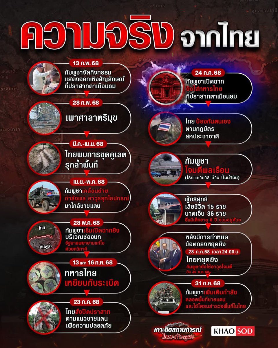
This morning (27 July 2025) around 4:30 hrs., heavy artillery shots were fired into civilian homes in Surin province in Thailand by Cambodian armed forces.
.
Thailand condemns in the strongest terms this egregious and repeated violation of international law and calls on Cambodia to immediately cease attacking civilian targets.
.
#Thailand #Cambodia
#ThailandCambodia
#CambodiaOpenedFireFirst
#TheStandardNews
🧵A detailed timeline on escalations in the lead-up to yesterday's clashes between Thailand and Cambodia.
Much of the escalation seems to stem from Cambodia, with their troops fortifying many sectors before the May 28 clashes and surging strategic assets immediately after.
🗺️ - heatmap of Cambodian military developments prior to July 24th.
Ongoing 🧵of territorial changes in the Thailand-Cambodian clashes.
Thai forces have advanced from multiple axes ~300m beyond the Cambodian frontline positions and towards the village of Ta Thav. They have also advanced to the edge of the plateau near Khao Sattasom.
นักวิเคราะห์ข้อมูลดาวเทียมออสเตรเลีย พบหลักฐาน ความขัดแย้งเริ่มจากฝั่งกัมพูชา
นาธาน รูเซอร์ ซึ่งเป็นผู้เชี่ยวชาญการวิเคราะห์ข้อมูลดาวเทียม ของ Australian Strategic Policy Institute หรือ ASPI บอกว่าเขานั่งไล่ดูข้อมูลแล้ว สถานการณ์ที่ถูกยกระดับส่วนใหญ่น่าจะเริ่มต้นจากฝั่งกัมพูชา โดยทหารของกัมพูชาได้เสริมกำลังในหลายพื้นที่ก่อนการปะทะเมื่อวันที่ 28 พ.ค. (ไม่ใช่รอบนี้นะครับ หมายถึง รอบเดือน พ.ค. ที่เป็นจุดเริ่มต้นของความขัดแย้งรอบนี้) และกัมพูชายังเร่งส่งทรัพยากรทางยุทธศาสตร์เพิ่มเติมทันทีหลังเหตุการณ์
โดยเขาแนบแผนที่แสดงความหนาแน่นของกิจกรรมทางทหารของกัมพูชาก่อนวันที่ 24 ก.ค. มาด้วย
นักวิเคราะห์คนนี้ทำข่าวพื้นที่สงครามมาหลายจุด ทั้งยูเครน พม่า ค่อนข้างแม่นยำ ที่ผ่านมามีสื่อใหญ่นำข้อมูลของเขาไปใช้บ่อยครั้ง
ข้อมูลดาวเทียมนี้เป็นของที่บิดผันไม่ได้ ขอให้ทุกท่านช่วยกันแชร์ออกไป เพื่อยืนยันแก่ชาวโลกว่าเกิดอะไรขึ้น
Mr. Nathan Ruser, a satellite imagery analyst at the Australian Strategic Policy Institute (ASPI), stated that after closely examining the data, most of the escalation appears to have originated from the Cambodian side. Cambodian troops reinforced several areas prior to the May 28 clashes (refer to the earlier event which marked the beginning of this current conflict). Cambodia also rapidly deployed additional strategic assets immediately following the incident.
He included a heatmap showing the concentration of Cambodian military activity prior to July 24.
Mr. Ruser has covered conflict zones in multiple regions—including Ukraine and Myanmar—and has built a reputation for accuracy. His findings are frequently cited by major international media outlets.
Satellite data of this nature is immutable. We urge everyone to share this widely, so the world can clearly see what has really taken place.
cr: เพจ The Wild Chronicles - ประวัติศาสตร์ ข่าวต่างประเทศ ท่องเที่ยวที่แปลก
#cambodiaopenedfirefirst #cambodiastartedTheWar #CambodiaViolatesOttawaConvention #กัมพูชายิงก่อน #ทหารไทย