•Decreasing clouds on Friday
•Temperatures to warm back into the mid 60s to low 70s, particularly for interior locations
•Increasing potential for marine layer clouds to develop along the outer coast this weekend
•Latest forecast: https://t.co/i2y4s0zMaT
#akwx
NWS Juneau is hiring!!
We are looking to fill 2 positions in our electronics shop that maintain our vital weather observing equipment and NOAA Weather Radio across all of SE AK.
Closes April 9th
To apply, please review the full position posting here: https://t.co/ClDD4NvLuj
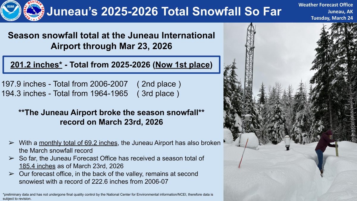
As of the March 23rd climate report, we have reached 201.2 inches of snowfall at the Juneau International Airport, breaking the seasonal snowfall record.
New Seasonal Snowfall Rankings:
1.) 201.2 inches: 2025 - 2026
2.) 197.9 inches: 2006 - 2007
3.) 194.3 inches 1964 - 1965
Winter has not release its grip on Southeast Alaska. A fast moving system this weekend will likely spread snow from northern Panhandle south towards the Ketchikan area. Follow your local forecast for further details. Cooler and drier conditions expected next week. #akwx
Reports of water on roadways and seeping into homes are trickling into the forecast office. As this system continues, are you experiencing any impacts? If so, we'd love to hear about it!
For residents living in Juneau, please report impacts to [email protected]#akwx
An atmospheric river will move across the panhandle starting late Thursday and lasting through early Saturday morning. Several hazards are out for various areas of the panhandle.
For more information, you can watch our youtube weather brief here:
https://t.co/THkqwSHBPA
Snow showers continue tonight up North. A break in precipitation may be possible towards the latter half of the week, before the next significant system moves in on Monday.
View the latest Minute with a Meteorologist on our YouTube Channel here: https://t.co/0aTMdJqf1D
Winter Storm Warnings and Winter Weather Advisories have been issued for this weekend. Snow is expected to move in Saturday morning, with a transition to rain following into Sunday. Heavy rain will continue Monday, increasing potential for minor flooding and other impacts.
A Winter Storm Watch has been issued for heavy snow this weekend. Heaviest snow is expected Saturday, with a transition to rain pushing north by Sunday. The attached graphic depicts the current approximated timing, though confidence will increase closer to the event.
Good Afternoon SE AK. A front is headed toward the panhandle that will bring widespread moderate to heavy precipitation. Yakutat and areas across the southern panhandle, from Angoon and southward, will see all precipitation fall as rain.
Mixed bag of light precip across the N panhandle this Thu evening with mostly a mix of rain and snow as of 530 pm. Snow accumulation of 0.3" in the back of the Mendenhall Valley. Light precip is expected to continue with a gradual change over to mostly rain near sea level late.
Good Afternoon, SE AK. It wouldn't be fall if we weren't expecting another low and associated front to impact the panhandle. What makes this next system different from what we have seen earlier this week is a growing likelihood for hurricane force winds. #akwx
With current flood predictions, we are not anticipating having to disconnect power to any area other than the campground. We will closely monitor flood levels and provide updates if conditions change.
Curious why your microwave and oven clocks are fast? The time that is displayed on plug-in devices that do not connect to the internet, like microwaves and ovens, depends on the frequency of the system to be accurate. A high system frequency will result in a clock being fast, while a low system frequency will result in a clock being slow. Typically, we monitor the difference between our local time and real time and adjust our system frequency to maintain accurate time. The device that we use to accumulate and display the error between local and real time failed at the end of the week last week, which reduced our ability to make our normal, small adjustments, and resulted in a larger offset between local time and real time than you’d normally see. These minor changes in frequency are inherent in an islanded hydropower system like Juneau and should only affect your clocks and not your power quality. We are currently working on a fix. (📸 courtesy of the internet)
Local hydrologists met late this afternoon and made some adjustments to the Mendenhall Flooding Forecast. The crest is still expected to reach over 16' but the timing has been moved up to Wednesday morning.
https://t.co/cTjB0wDXsr