Shock to the system 🥶
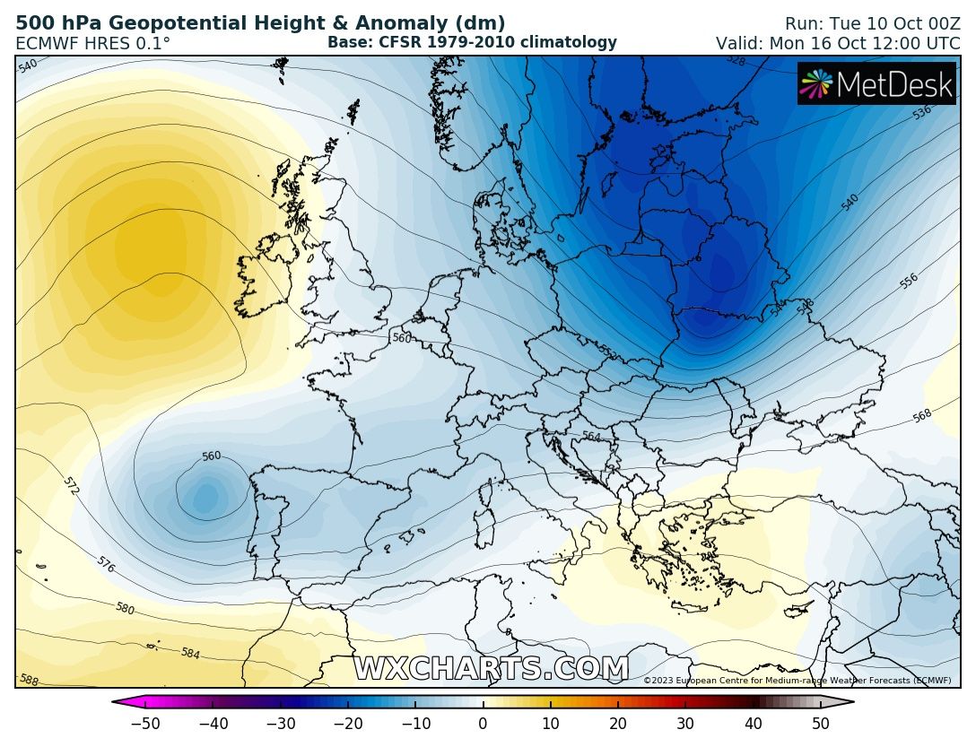
Unusually strong cold is pouring south out of the Arctic into Europe right now. This is an ideal setup for deep fresh snow accumulations in the Alps and flooding in Central Europe.
This is about as cold as it gets this early in September.
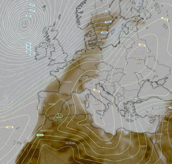
One thing that I thought I'd escape in moving to Switzerland from Jordan was the dust/sand. Interestingly, the Sahara makes its presence felt here. Last weekend there was "sand rain" that mucked up my car and it looks to be coming back - this for Saturday
"I will not tire of declaring that if we really want an effective end to violence we must remove the violence that lies at the root of all violence: structural violence, social injustice, exclusion of citizens from the management of the country, repression..."
In this time of #Lent, let us strive not to put ourselves at the centre; rather, let us try to step aside to make room for others, to promote them, and to rejoice in their qualities and successes. #GeneralAudience
In a @UNICEF-supported #Makani centre in Amman, the @EUinJordan announced €10 million in funding to help improve the inclusion, learning and wellbeing of vulnerable children and youth across Jordan.
📰Read the news note: https://t.co/apnktPxGNt
@EUinJordan@Lambrpa
The term "Goodyear welt construction" refers to how the soles have been attached to the uppers. In this method, the uppers, insole, and outsole are attached using a welt and some stitching. 🧵
Powerful foehn storm in Piedmont region, Italy. A weather station at Sacra di San Michele, at an elevation of 938 m, recorded a wind gust of 228 km/h (142 mph) at 06:30 am local time today. If confirmed, this would be one of highest wind gusts ever recorded in Europe.
With today's clearing skies, the Copernicus Sentinel-3 satellite got a clear view of the extent of snow cover over the Alps and southern Germany. Simply stunning.
Significant snowfall accumulations are expected across the Alps over the next few days. Some areas could see as much as 1 to 2 metres of fresh snow. The European mountain range will likely kick off meteorological winter with its highest snowpack in recent years.
È arrivato stamattina in Piazza della Riforma, trasportato in elicottero da Bioggio, l'albero di #Natale di #Lugano: un abete normandiano di 3'800 chili e alto 16 metri. L'accensione è prevista il 1° dicembre🎄Per maggiori dettagli: https://t.co/PMEXVGlKPf #luganomycity
Excited to be able to do this from a new location - it would appear that the end of "summer" for southern Switzerland is coming this weekend. What will this mean? Well, for me - it means my family puts away the summer clothes and unpacks what for Jordan were our "winter stuff".
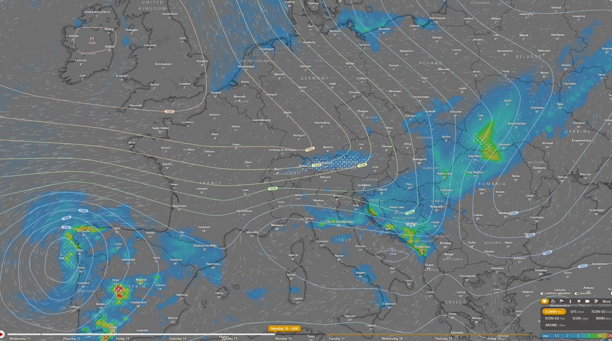
Tra domenica e lunedì. Ormai tutti i modelli matematici previsionali sono concordi verso un radicale mutamento della circolazione atmosferica sull'Europa Occidentale e sul Mediterraneo a partire dal weekend. Dove oggi c'è ancora l'anticiclone, dalla prossima settimana ci sarà una vasta area di bassa pressione alimentata da correnti fresche nord-atlantiche.
Per la nostra penisola, il cambiamento avverrà tra domenica e lunedì, a cominciare dal Centro-Nord. Domani e dopodomani entrerò maggiormente nei dettagli, ma è possibile affermare con relativa certezza ormai che le temperature torneranno nella media del periodo e che si aprirà un periodo d'instabilità atmosferica con piogge, temporali e prima neve sulle Alpi, anche a quote medie.
Autunno. Finalmente c'è anche una data sull'arrivo di condizioni meteo prettamente autunnali. Vi ho spiegato sin dal 6 settembre come il declino estivo sarebbe stato lento e che solo dopo il 20 settembre avremmo avuto il vero autunno. Effettivamente sarà così.
I maggiori modelli matematici previsionali iniziano ad allinearsi verso una tendenza chiara e netta. Il 22 settembre si cambia registro. L'anticiclone verrà definitivamente spazzato via da correnti nord-atlantiche. Non si tratterà di una goccia fredda isolata sul Mediterraneo ma di un sistema perturbato strutturato che permetterà il costante afflusso di aria fresca dal Nord Europa fino alla fine del mese.
Oltre all'arrivo di aria più fresca e di un consistente calo delle temperature avremo sicuramente anche molta instabilità atmosferica ma di questo ne parleremo più avanti.