Except that there is no genetic or archaeological support for thousands or millions of people from a different origin living here first and then being overwritten. Claims of significant Ice Age European ancestry (such as the Solutrean idea) have been tested against ancient genomes and do not hold up.
The Timucua (tih-MOO-kwah): Chiefdoms of Northern Florida and a Language Isolate
Documented by Spanish Friars
The Timucua (tih-MOO-kwah) were not a single tribe. The name covers a set of related chiefdoms that spoke dialects of one language and occupied northern Florida and southeastern Georgia at European contact. Their territory ran from roughly the Altamaha (AL-tuh-muh-HAW) River in Georgia south to the area around present-day Daytona, and west to the Withlacoochee (with-luh-KOO-chee) and Suwannee (suh-WAH-nee) drainages. That is about 19,200 square miles. They were the largest Indigenous language group in that region.
Pre-contact population estimates for the whole Timucua-speaking area are commonly placed between 150,000 and 200,000. Individual chiefdoms were much smaller, typically a few hundred to a few thousand people.
Origins and the St. Johns Culture
They were not recent arrivals. Archaeological continuity links the historic Timucua of northeast Florida to the long St. Johns culture of the St. Johns River valley and adjacent Atlantic coast. That tradition itself grew directly out of the Late Archaic Orange culture.
The Orange culture (roughly 2500 to 1000/500 BC) marks the appearance of the first pottery in the region. The vessels are fiber-tempered, usually with Spanish moss or similar plant fiber. The earliest secure dates fall around 2000 BC. Sites of this period are dominated by shell middens and, in places, shell rings. People lived in small groups near the coast, the lower St. Johns, and associated wetlands. They relied heavily on shellfish, fish, and other aquatic resources, supplemented by hunting and plant gathering. Settlement was relatively dispersed. There is little evidence of strong ranking or intensive agriculture.
Around 1000 to 500 BC the fiber-tempered Orange pottery is replaced by the pottery that defines the St. Johns culture: chalky spiculate ware. The clay contains microscopic freshwater sponge spicules. These give the vessels their soft, chalky surface. This paste remains the dominant ceramic marker for the next two thousand years.
The culture is centered on the St. Johns River and its tributaries, especially the Oklawaha (oak-luh-WAH-hah). It extends along the Atlantic coast from the river mouth south toward present-day Cocoa Beach. Villages and camps sat beside rivers, lakes, lagoons, and estuaries. Large shell middens accumulate across the region. Some cover several acres and originally rose 20 to 75 feet high. Inland middens are built mainly of freshwater snails. Coastal ones are dominated by oyster and other marine shell.
For most of the sequence people continued to rely on fish, shellfish, turtles, and wild plants. Maize, beans, and squash appear relatively late in the northern part of the area, around AD 750, and possibly later farther south. The southern end of the St. Johns culture area, associated with the historic Mayaca (my-AH-kuh), still lacked significant maize agriculture at the time of European contact.
Ceramic phases are conventionally divided into St. Johns I (roughly 500 BC to AD 750/1000, mostly plain chalky ware with some incised types) and St. Johns II (later centuries to contact, when check-stamped varieties become common).
Neighboring Woodland cultures such as Deptford and Swift Creek appear as occasional trade or influence. The local chalky-ware tradition and riverine-coastal adaptation remain continuous and dominant.
At Spanish and French contact in the 1500s the St. Johns culture area was occupied by speakers of Timucua dialects. Mocama (moh-KAH-muh) or Agua Salada (AH-gwah sah-LAH-dah) lived on the coast. Agua Dulce (AH-gwah DOOL-say) lived along the lower river. Acuera (ah-KWEH-ruh) lived farther inland.
The Mayaca lived farther south on the upper St. Johns and shared the ceramic tradition but were not Timucua speakers. Archaeologists treat the historic Timucua of this region as the later expression of the same long-lived St. Johns tradition. The villages, shell middens, chalky pottery, and aquatic economy continue without a sharp break into the period documented by Europeans.
Language
Timucua is a language isolate. It has no clear genetic relatives among other North American languages. Proposals linking it to Muskogean or to certain South American families (Arawakan, Cariban) have not held up under close comparison.
Franciscan missionary Francisco Pareja arrived in St. Augustine around 1595 and worked among Timucua speakers for decades. Between 1612 and 1627 he published a grammar and several bilingual catechisms. These are the earliest substantial written records of any Indigenous language in the territory that became the United States.
Two secular letters written by Timucua leaders also survive. Pareja noted nine or ten dialects with only minor differences, mostly marking local group boundaries.
The language is extinct as a spoken tongue. The last known unmixed speakers were among the people evacuated to Cuba in the 1760s.
Culture and Daily Life
By the historic period the Timucua lived in permanent villages near rivers and wetlands. Maize, beans, and squash formed the agricultural base in the north, supplemented by hunting, fishing, and gathering. Houses were circular, palm-thatched structures. Larger towns had central plazas and council houses.
Leadership was hereditary and ranked. Chiefs (often called caciques, kah-SEE-kays, in Spanish records) held authority over multiple villages. Some accounts note matrilineal elements in succession. The name Timucua itself may derive from a native term for “lord” or “chief” (atimoqua, ah-tih-MOH-kwah), applied by outsiders to the people.
Craft production included pottery in the St. Johns tradition, shell tools, and woven goods. Social organization was hierarchical within each chiefdom but not unified across the whole Timucua-speaking area.
Neighboring groups sometimes allied and sometimes fought. Trade networks moved goods inland and along the coast. Mortuary practices varied. Some groups used mounds or charnel structures for secondary burial of cleaned bones.
Religion
Pre-contact religion was animistic. Spanish and French observers recorded attention to the sun and moon, shamanic specialists, and ritual cycles tied to agriculture and hunting. Platform mounds or special structures appear at some sites.
After the late 1500s the Franciscan mission system imposed Catholic practice. Many Timucua were baptized and incorporated into mission towns. The catechisms Pareja wrote were tools of that conversion effort. Indigenous elements persisted alongside the new religion for decades.
Contact and Conflicts
Early Spanish expeditions (Ponce de León in 1513, Narváez in 1528, de Soto in 1539–1540) passed through or near Timucua territory. French Huguenots under René de Laudonnière established Fort Caroline near the mouth of the St. Johns in 1564 and interacted with the local Saturiwa (sah-too-REE-wah) chiefdom.
The Spanish under Pedro Menéndez de Avilés destroyed the French colony in 1565 and founded St. Augustine.
From the 1590s Franciscan missions spread among the Timucua chiefdoms (San Juan del Puerto, San Martín de Timucua, and others). The system demanded labor, relocated people into mission towns, and exposed them to repeated epidemics.
In 1656 a rebellion broke out in the Timucua mission province over Spanish demands and local grievances. It was suppressed. Far more destructive were the raids that began in the late 1600s and peaked in 1702–1705. English colonists from Carolina, allied with Creek, Yamasee (YAH-muh-see), Catawba (kuh-TAW-buh), and Yuchi (YOO-chee) warriors, systematically attacked the Spanish missions. They burned churches, killed inhabitants, and carried captives north to be sold as slaves. Most remaining Timucua towns were destroyed in those years.
Downfall
Disease was the primary killer. Major epidemics are documented in 1613–1617, the late 1640s–1650s, and the 1670s. Population fell from the high tens or low hundreds of thousands at contact to roughly 50,000 by 1595 and to about 1,000 by 1700. The slave raids finished the collapse.
By the 1720s only a few hundred Timucua remained near St. Augustine. In 1763, when Spain ceded Florida to Britain, the last organized groups were evacuated to Cuba. One man identified in Cuban records as the last unmixed Timucua speaker died in Guanabacoa (gwah-nah-bah-KOH-ah) in 1767. No distinct Timucua nation or fluent speakers survived. Some individuals or families may have been absorbed into Spanish colonial society or into the emerging Seminole population, but the language and the chiefdoms ended.
What remains is archaeological (village sites, mounds, mission ruins), the Spanish documentary record, and the linguistic corpus created by Pareja and his colleagues. The Timucua are one of the better-documented extinct peoples of the Southeast precisely because the missionaries wrote so much in and about their language. They are also one of the clearest cases of a large language family disappearing within two centuries of sustained European contact. The St. Johns culture that preceded them shows that the riverine and coastal adaptation had already been in place for more than two thousand years.
Images: Theodor de Bry engraving (1591), based on sketches made by Jacques le Moyne during the French colony at Fort Caroline in 1564. It shows Timucua people in a canoe near a thatched house on the St. Johns River. These are the earliest European visual records of the Timucua. De Bry worked in Europe from Le Moyne’s notes and added some inaccuracies, but the plates remain the standard contemporary images of Timucua life.
Map of the broad Timucua territory in northern Florida and southern Georgia at European contact, shown relative to neighboring groups such as the Apalachee and Guale (GWAH-lee).
Milky quartz is common in the north Georgia Piedmont and Blue Ridge and was commonly used for tools there.
In a north Georgia context, small triangular or simple forms like these most commonly align with Late Woodland to Mississippian period points (roughly AD 500–1600).
Types such as Hamilton/Late Woodland Triangular or Madison/Mississippian Triangular are widespread in the region. They are typically small (often under ~3–4 cm), made for use with the bow and arrow, and frequently made from local quartz.
A gorgeous example of a Dalton point from Northwest Georgia made from banded chert.
Dalton points mark the Late Paleoindian period across the Southeast, including northwest Georgia. They date to roughly 10,500 to 9,900 radiocarbon years BP, or about 8500 to 7900 B.C.
Recent Bayesian analysis of radiocarbon data places the broader Dalton culture from around 12,680 calibrated years BP until at least 10,400 calibrated years BP.
These points were made and used by mobile hunter gatherer groups adapting to early Holocene environments after the end of the Pleistocene. They followed earlier Clovis related populations and represent a regional cultural pattern that spread widely through the Southeast.
Dalton people hunted deer and other game, gathered plant foods, and relied on versatile bifaces that served as projectiles, knives, and sometimes perforators. Many points show basal grinding for hafting and resharpening that produced serrated or beveled edges.
In Georgia the Chattahoochee form is the most common variant. Surveys have documented hundreds of Dalton points from dozens of counties. Northwest Georgia, in the Ridge and Valley province, falls within this distribution. Local black and banded cherts from the Fort Payne Formation and Knox Group provided the raw material.
Finds and collections from the area, including near the Conasauga and Coosa drainages, show use of these points in the ridges, valleys, and river bottoms of the region.
Dalton technology appears in open sites and occasional rock shelters. It reflects groups who adjusted settlement and tool design as climates and vegetation shifted. The points eventually gave way to Early Archaic side notched and corner notched types as populations and environments continued to change.
Good question. Ancestral Puebloans dried maize thoroughly before storing it, then used several methods to keep rodents and insects out.
Large pottery jars (often called seed jars) were common. These were sealed by packing wet clay around the rim and setting a pottery disk or lid into it. Underground pits were capped with a layer of mud that hardened into a tight seal. Masonry bins and storage rooms appear in many pueblos, including the rear rooms and lower stories at places like Pueblo Bonito. Some of those rooms were essentially windowless vaults.
Cliffside granaries built in high alcoves (common in places like the Grand Canyon and Mesa Verde area) added another layer of protection simply by location. Rodents had a harder time reaching them, and the masonry walls and sealed openings limited access.
Dogs were part of Ancestral Pueblo communities and almost certainly helped keep rodent numbers down around living and storage areas. Domestic cats, however, arrived only with European contact, so they were not part of the picture.
Your idea about sealing from above fits the documented pits and bins. Combined with drying, sealed containers, elevated or hard-to-reach storage, and dogs, they managed the rodent problem without cats.
The Origin of the Pueblo Peoples of the Southwest
The Pueblo peoples of the Southwest grew out of people who had already lived in the region for thousands of years. Their story runs from Paleoindian hunters through Archaic foragers to the farmers who built Chaco Canyon and the living Pueblos of today. Genetics, archaeology, and language all point to continuity and convergence rather than replacement by outsiders.
Deep genetic roots
Pueblo groups carry the same major maternal lineages (haplogroups A, B, C, and D) and the dominant paternal lineage (Q) that mark the founding population of Native peoples across the Americas. These lineages expanded after the Last Glacial Maximum and became the ancestors of virtually every later Indigenous group. They do not come from a separate or later arrival.
People were in the Southwest even earlier. The White Sands footprints in New Mexico date to roughly 21,000 to 23,500 years ago. That is before the main genetic expansion seen in living and later ancient Native populations. No DNA has been recovered from those footprints. The usual reading is that an earlier wave reached the continent during or before the ice age but left little or no lasting genetic trace. The population that carried the classic Native American lineages then expanded and gave rise to the Paleoindian hunters and, eventually, the Ancestral Puebloans.
From Paleoindian hunters to Archaic foragers
Folsom and Clovis people were part of that same continuum. Folsom (about 12,800 to 12,200 years ago) followed Clovis and is known for fluted points and bison hunting. Both cultures appear in the Southwest. The Anzick child from Montana, roughly 12,800 years old and associated with Clovis, already carried the standard Native American markers.
There is no evidence these early hunters were replaced by a different population. Over the following millennia their descendants broadened their diets, settled into local landscapes, and became the Archaic foragers of the Colorado Plateau and northern Rio Grande. Those foragers later adopted maize and developed the Basketmaker and Pueblo lifeways. The link is deep ancestral continuity, not a straight line from one Folsom band to one Pueblo village.
The arrival of maize, squash, beans, and peppers
The major crops came from Mesoamerica by gradual diffusion and local adoption, not through a mass migration of farmers who replaced local people.
Maize was domesticated from the wild grass teosinte in the Balsas region of southwestern Mexico around 9,000 years ago. It reached the US Southwest by about 2100 BC, with the earliest clear evidence in lowland sites such as the Tucson Basin. Genetic work on ancient cobs points to an initial highland route from Mexico, followed by later gene flow from lowland varieties. Archaic foragers simply added it to their existing way of life.
Squash (primarily Cucurbita pepo) was domesticated even earlier in Mesoamerica. The earliest clear evidence comes from Guilá Naquitz Cave in Oaxaca, where cultivated squash dates to roughly 10,000 years ago. It spread northward and reached the Southwest around the same time as the earliest maize or slightly after. Local people adopted it alongside maize.
The common bean (Phaseolus vulgaris) was also domesticated in Mesoamerica. It arrived later than maize and squash. The earliest well-documented Southwest finds generally fall between about 800 BC and AD 300. Beans became more common once pottery was in use during Basketmaker III and completed the classic three-sisters combination.
Chili peppers (Capsicum annuum) were domesticated in Mesoamerica as well. In the US Southwest, however, they appear much later and remain rare in the prehispanic record. The earliest confirmed cultivated chile comes from a site near Casas Grandes in Chihuahua, dated to about AD 1200–1450. They were not a major crop among Ancestral Puebloans. Peppers became far more prominent after Spanish contact. The famous chiles associated with the Southwest today largely reflect that later historic development.
The Basketmaker periods
The next major stage is known as the Basketmaker periods. The name comes from the excellent woven baskets these people made. Basketmaker marks the shift from mobile Archaic foraging to a more settled farming life based on maize, still before the full development of pottery and above-ground masonry villages.
There is no Basketmaker I. When the sequence was first outlined, researchers left a blank slot for a hypothetical earlier stage they expected to find. That stage never appeared as a clear pattern, so the label was dropped. The accepted sequence begins with Basketmaker II.
Basketmaker II (roughly 500 BC to AD 500) is the first well-defined stage. People lived in pithouses, semi-subterranean dwellings dug into the ground and roofed with poles and earth. They relied heavily on maize and squash, stored food in pits and baskets, and produced finely made baskets and sandals. Pottery had not yet appeared. Groups were becoming more sedentary and tied to particular farming locations.
Basketmaker III (about AD 500 to 750) built directly on that foundation. Beans were added to the diet. Pottery appeared and spread, mostly plain gray or brown utility wares at first, often with simple surface treatments. Decorated white wares with black painted designs began to develop toward the end of this period. Pithouses became larger and villages grew.
These developments occurred across the Colorado Plateau, including areas that would later become the Mesa Verde, Kayenta, and Chaco regions.
The Pueblo periods, regional centers, pottery, and trade
The Pueblo periods (about AD 750 to 1300) came next. People began building surface roomblocks of masonry or adobe, developed the kiva, and formed larger villages. Parallel developments took place across the northern Southwest.
Chaco Canyon in the San Juan Basin, especially from AD 900 to 1150, became a major center with multi-story great houses, roads, and a wide sphere of influence. At the same time, the Mesa Verde region in southwestern Colorado saw the growth of large villages and, later, the famous cliff dwellings that peaked in the 1200s. The Kayenta region in northeastern Arizona and the Little Colorado area developed their own variants of the same broad pattern. These were related regional expressions of Ancestral Puebloan culture, not separate peoples.
Pottery became one of the clearest markers of regional identity. Ancestral Puebloan potters used the coil-and-scrape technique. Utility pottery was usually gray or brown, often corrugated. Serving and ceremonial vessels were typically white or light-colored with black paint. Designs included parallel lines, triangles, scrolls, and geometric motifs.
Regional styles differed in the details. Chaco and Cibola white wares are characteristic of the central San Juan Basin. Mesa Verde black-on-white pottery, associated with the northern San Juan region, becomes especially prominent in the later Pueblo III period and is known for polished surfaces and forms such as mugs and Tusayan styles farther west used different temper, paint, and design conventions. The styles are related but not identical. They reflect local traditions within a wider shared cultural world.
Chaco Canyon sat at the center of extensive trade networks. More than 200,000 pieces of turquoise have been recovered from the canyon. Much of it came from deposits in Colorado, Nevada, and southeastern California as well as nearer sources. Chaco also received marine shell, copper bells, cacao, and scarlet macaws. These long-distance connections were active from the 900s onward. Exotic goods appear concentrated in great houses such as Pueblo Bonito. Mesa Verde and other regions participated in regional exchange as well, including the movement of pottery.
After about AD 1300 many communities across the Four Corners, including those in the Mesa Verde region, shifted toward the Rio Grande, the Hopi mesas, and Zuni. Prolonged drought, resource stress, and social factors all played a role. Oral traditions describe purposeful movements and continuing ties to earlier places. The people did not vanish. Later Pueblo pottery continued and refined many of these traditions.
What the languages show about origins
The languages show that this shared culture did not grow out of a single ancestral people who all spoke the same language. It formed among several groups with separate deep linguistic roots that later converged in the Southwest.
Kiowa-Tanoan is the family spoken by the Tiwa (Northern Tiwa at Taos and Picuris, Southern Tiwa), the Tewa, and the Towa at Jemez. It is related to the language of the historically nomadic Kiowa of the Plains. Reconstructions place the proto-language in an upland environment near the Rocky Mountains among hunter-gatherers.
The split within Tanoan is relatively recent, with Proto-Tanoan dating roughly to Basketmaker times. This points to a northern or Rocky Mountain origin for these groups, followed by a move into the Southwest and a later shift to the Pueblo pattern.
Hopi is a Northern Uto-Aztecan language. The wider family stretches from the Great Basin and California into Mexico. Most recent work places the Proto-Uto-Aztecan homeland near southern California roughly 4,100 years ago among foragers.
Agriculture spread later by diffusion. Hopi most likely entered the Colorado Plateau as Uto-Aztecan speakers and adopted maize farming and Pueblo traits through contact.
Keresan (spoken at Acoma, Laguna, and several other pueblos) is a language isolate. Zuni is also a language isolate. Neither shares a recent common linguistic ancestor with the Tanoan or Hopi groups.
This pattern indicates that the distinctive Pueblo way of life emerged among people who already spoke different languages and who had different deeper origins. Tanoan speakers appear to have roots among northern or Rocky Mountain foragers. Hopi speakers belong to a family whose homeland was farther west. Keresan and Zuni speakers represent lineages that are linguistically independent of both.
Over centuries of living near one another, these groups adopted and refined a common cultural pattern. The cultural unity of the Pueblos is the result of convergence among separate ancestral populations, not descent from one founding group that later split.
Continuity into the present
Modern Pueblos keep the architecture, the maize-beans-squash agriculture, the clan systems, and the oral histories. A 2025 study initiated by Picuris Pueblo found that ancient individuals from roughly 500 to 700 years ago and living members are most closely related to each other and to people buried at Pueblo Bonito in Chaco Canyon.
There was no detectable Athabascan (Navajo and Apache) ancestry before about AD 1500 and no major pre-European population collapse.
In short, Ancestral Puebloan culture developed in place from local foragers who descended from the same Paleoindian populations that made Folsom and Clovis points. They adopted maize, squash, and later beans that had diffused north from Mexico, moved through the Basketmaker stage, and built one of the most distinctive cultures in North America.
Parallel developments at Chaco Canyon, Mesa Verde, Kayenta, and other regions produced related but locally distinct expressions of that culture, marked by regional pottery styles and linked by trade.
The languages show that this happened among groups with separate deep origins that later converged. Their descendants are still here.
Images
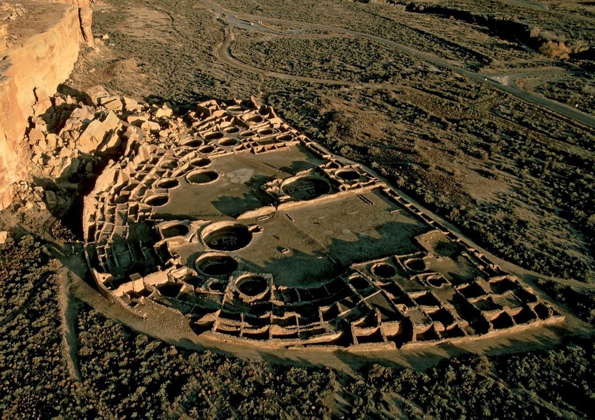
Aerial view of Pueblo Bonito at Chaco Canyon, showing the great house layout with numerous circular kivas and roomblocks.
Cliff Palace at Mesa Verde, one of the largest cliff dwellings of the Mesa Verde region.
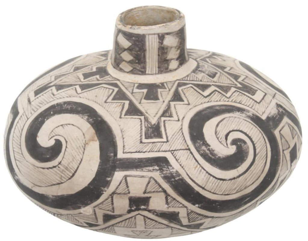
Black-on-white jar with geometric designs typical of Cibola white ware traditions.
Tularosa-style olla with bold interlocking scrolls and hatchure, roughly AD 1150–1300.
Why the Ancient Architecture of South America Looks So Different from North America
The fitted stone walls of the Inca and the great pyramids and platforms of Mesoamerican societies remain among the most striking engineering accomplishments of the precontact Americas.
In the Andes, Inca builders and their predecessors shaped massive blocks so precisely that many joints still admit no blade. Some individual stones weighed more than 100 tons and were moved and set without wheeled vehicles or iron tools. Those walls, terraces, and sites such as Machu Picchu have stood through centuries of earthquakes.
In central Mexico the people of Teotihuacan raised an immense planned city that at its height held an estimated 100,000 or more residents, with broad avenues and massive platforms. Maya and later Mexica architects created temple pyramids, ballcourts, and urban centers aligned to celestial events and supported by intensive maize agriculture and organized labor.
Farther south and much earlier, the Norte Chico civilization at Caral in coastal Peru constructed large platform pyramids around 2600 BC, roughly contemporary with the earliest pyramids in Egypt.
These works grew from environments that supported dense populations and from political systems able to coordinate large building projects over long periods. The Andes offered stacked ecological zones and irrigable valleys where potatoes, quinoa, and maize could be grown intensively, while domesticated llamas helped move goods and materials. Coastal Peruvian valleys combined rich fisheries with early irrigation.
In Mesoamerica, long developed maize varieties and fertile basins supported high densities that made permanent urban centers practical. Stone was abundant in the highlands, and the combination of surplus and organization favored large, lasting masonry projects.
Political organization played a major role in the scale of these projects. In the Andes the Inca empire developed a highly centralized system with a labor tax known as the mit’a, state managed storehouses, and a vast road network that moved workers, materials, and food across long distances. Earlier Andean states such as Wari and Tiwanaku also mobilized large workforces for architecture and infrastructure.
In Mesoamerica, Teotihuacan functioned as a major urban center with evidence of coordinated planning, while the Mexica (Aztec) empire relied on tribute networks and alliances that concentrated resources in the capital. Maya societies often organized as competing city states with powerful rulers who sponsored temples and public works. These systems arose where intensive agriculture produced reliable surpluses large enough to support full time specialists, administrators, and the sustained labor needed for monumental stone construction.
North American societies produced their own durable and sophisticated architecture suited to local conditions. Ancestral Pueblo peoples in the Southwest used sandstone masonry for multistory great houses at Chaco Canyon and for cliff dwellings at places such as Mesa Verde.
Mississippian communities at Cahokia, near present day St. Louis, constructed more than one hundred earthen mounds, including Monks Mound, the largest indigenous earthwork north of Mexico. At its height roughly 1050 to 1200 AD the Cahokia core held an estimated 10,000 to 20,000 people (with regional figures higher) and was comparable in scale to London of the same era. It served as a major trade and ceremonial center.
Much earlier, the hunter gatherers of Poverty Point in Louisiana built a vast complex of concentric ridges and mounds, now a UNESCO World Heritage Site.
Political organization in North America tended toward complex chiefdoms rather than expansive territorial empires. At Cahokia archaeologists see evidence of social ranking, elite residences on mounds, and the ability to organize large communal projects, yet the system appears more centered on ritual authority, kinship, and regional influence than on a standing bureaucracy that ruled distant provinces.
Chaco Canyon shows signs of coordinated planning and long distance trade, but power seems to have rested in religious and economic networks rather than a single imperial state. Many Eastern Woodlands societies operated through ranked lineages and temporary coalitions that could gather people for earthwork construction or seasonal ceremonies without permanent urban capitals. These arrangements were effective for the environments they inhabited.
Several theories help explain the difference in political scale. Intensive agriculture developed earlier and supported higher population densities in parts of the Andes and Mesoamerica, crossing thresholds that made state level organization and permanent cities more likely. The vertical ecology of the Andes and the fertile basins of central Mexico allowed surplus production in relatively compact areas that could be controlled and taxed.
In much of North America maize arrived later, growing seasons were shorter in many regions, and abundant wild resources meant communities could thrive with mixed economies that did not require the same degree of centralization. Large domesticated animals useful for transport existed in the Andes but not in North America, which limited the logistical reach of any political system.
Seasonal variability and the practicality of earth and timber construction also shaped choices. Some researchers note that complex chiefdoms can remain stable for centuries without evolving into empires, and that not every society that reaches a certain population size chooses the same path.
None of this reflects lesser skill or effort. Communities across North America adapted materials, crops, and building techniques to their own landscapes with notable success. The precise Inca masonry, the monumental Mesoamerican centers, and the early pyramids at Caral inspire admiration. So do the earthworks of Cahokia and Poverty Point and the stone pueblos of the Southwest. All document the range of indigenous ingenuity across the Americas.
Images:
Inca builders fitted massive stones with no mortar so tightly that many joints still admit no blade. Walls and terraces at sites such as Machu Picchu have endured earthquakes for centuries.
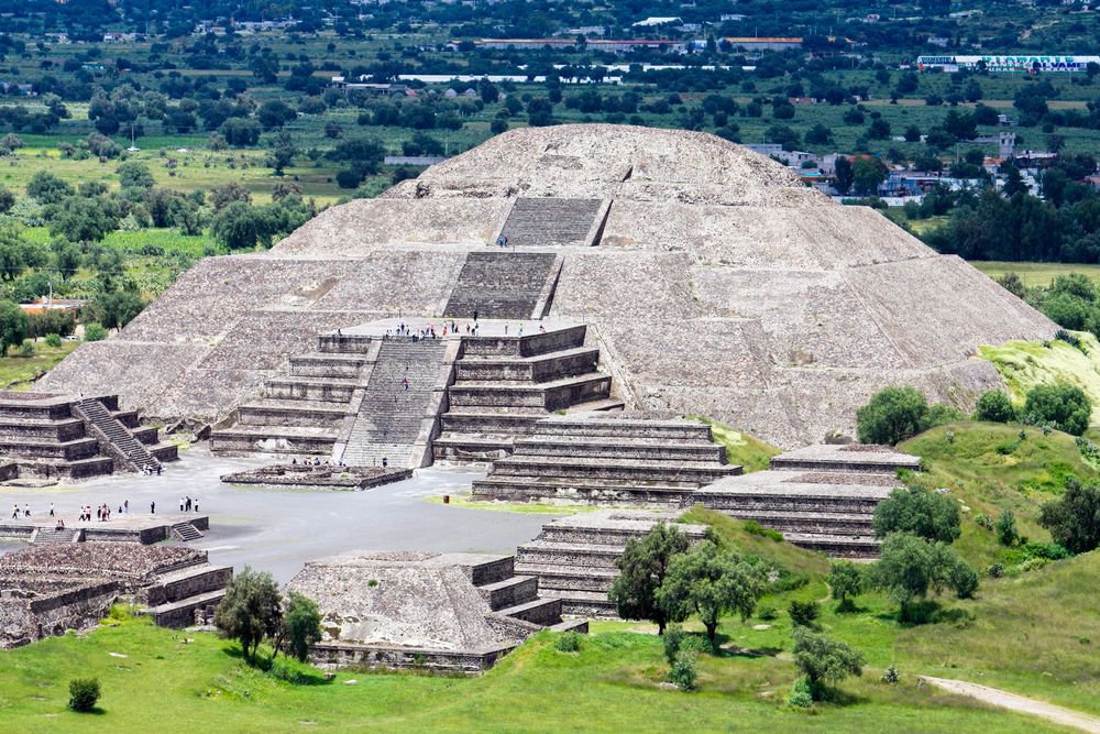
Maya and other Mesoamerican architects raised large stepped platform pyramids and temples, often with broad stairways and alignments to celestial events, supported by intensive agriculture and organized labor.
Ancestral Pueblo peoples used local sandstone masonry for compact multi-room dwellings, including cliff houses with kivas, adapted to the arid Southwest and limited water resources.
Mississippian mound builders at Cahokia and related sites constructed large earthen platform mounds from layered soil, including Monks Mound, the largest indigenous earthwork north of Mexico, as centers for ceremony and community.
Interesting thought. Pueblo Bonito and the other Chaco great houses do have large numbers of storage rooms, and maize was the dietary staple. Isotope work shows some of the maize found at Pueblo Bonito was brought in from outside the canyon, including areas near the Chuska Mountains.
They did not live on maize alone. Beans and squash were grown with it in the classic Three Sisters system, and people also gathered wild plants such as piñon nuts, amaranth, and yucca. For protein they hunted deer and rabbits, and they raised domesticated turkeys.
Turkey husbandry is well documented among Ancestral Puebloans from Basketmaker times onward. The birds were kept in pens, fed maize, and used for feathers, eggs, and later meat as deer became scarcer in some areas.
Chaco sat at the center of an extensive regional network.
Turquoise is one of the clearest markers of that trade. Hundreds of thousands of pieces have been recovered from the canyon, sourced from deposits in New Mexico, Colorado, Nevada, and California. It was a high-value prestige good used in ritual objects, ornaments, and exchange, so in that sense it functioned as a form of wealth.
Pemmican is more characteristic of Plains bison hunters. Significant trade in bison products between Pueblo communities and Plains groups is better documented later, after about 1450. During the main Chaco period the evidence points more to local and regional protein sources (hunting plus turkey husbandry) along with the imported maize and other goods that supported the canyon.
The Origin of the Pueblo Peoples of the Southwest
The Pueblo peoples of the Southwest grew out of people who had already lived in the region for thousands of years. Their story runs from Paleoindian hunters through Archaic foragers to the farmers who built Chaco Canyon and the living Pueblos of today. Genetics, archaeology, and language all point to continuity and convergence rather than replacement by outsiders.
Deep genetic roots
Pueblo groups carry the same major maternal lineages (haplogroups A, B, C, and D) and the dominant paternal lineage (Q) that mark the founding population of Native peoples across the Americas. These lineages expanded after the Last Glacial Maximum and became the ancestors of virtually every later Indigenous group. They do not come from a separate or later arrival.
People were in the Southwest even earlier. The White Sands footprints in New Mexico date to roughly 21,000 to 23,500 years ago. That is before the main genetic expansion seen in living and later ancient Native populations. No DNA has been recovered from those footprints. The usual reading is that an earlier wave reached the continent during or before the ice age but left little or no lasting genetic trace. The population that carried the classic Native American lineages then expanded and gave rise to the Paleoindian hunters and, eventually, the Ancestral Puebloans.
From Paleoindian hunters to Archaic foragers
Folsom and Clovis people were part of that same continuum. Folsom (about 12,800 to 12,200 years ago) followed Clovis and is known for fluted points and bison hunting. Both cultures appear in the Southwest. The Anzick child from Montana, roughly 12,800 years old and associated with Clovis, already carried the standard Native American markers.
There is no evidence these early hunters were replaced by a different population. Over the following millennia their descendants broadened their diets, settled into local landscapes, and became the Archaic foragers of the Colorado Plateau and northern Rio Grande. Those foragers later adopted maize and developed the Basketmaker and Pueblo lifeways. The link is deep ancestral continuity, not a straight line from one Folsom band to one Pueblo village.
The arrival of maize, squash, beans, and peppers
The major crops came from Mesoamerica by gradual diffusion and local adoption, not through a mass migration of farmers who replaced local people.
Maize was domesticated from the wild grass teosinte in the Balsas region of southwestern Mexico around 9,000 years ago. It reached the US Southwest by about 2100 BC, with the earliest clear evidence in lowland sites such as the Tucson Basin. Genetic work on ancient cobs points to an initial highland route from Mexico, followed by later gene flow from lowland varieties. Archaic foragers simply added it to their existing way of life.
Squash (primarily Cucurbita pepo) was domesticated even earlier in Mesoamerica. The earliest clear evidence comes from Guilá Naquitz Cave in Oaxaca, where cultivated squash dates to roughly 10,000 years ago. It spread northward and reached the Southwest around the same time as the earliest maize or slightly after. Local people adopted it alongside maize.
The common bean (Phaseolus vulgaris) was also domesticated in Mesoamerica. It arrived later than maize and squash. The earliest well-documented Southwest finds generally fall between about 800 BC and AD 300. Beans became more common once pottery was in use during Basketmaker III and completed the classic three-sisters combination.
Chili peppers (Capsicum annuum) were domesticated in Mesoamerica as well. In the US Southwest, however, they appear much later and remain rare in the prehispanic record. The earliest confirmed cultivated chile comes from a site near Casas Grandes in Chihuahua, dated to about AD 1200–1450. They were not a major crop among Ancestral Puebloans. Peppers became far more prominent after Spanish contact. The famous chiles associated with the Southwest today largely reflect that later historic development.
The Basketmaker periods
The next major stage is known as the Basketmaker periods. The name comes from the excellent woven baskets these people made. Basketmaker marks the shift from mobile Archaic foraging to a more settled farming life based on maize, still before the full development of pottery and above-ground masonry villages.
There is no Basketmaker I. When the sequence was first outlined, researchers left a blank slot for a hypothetical earlier stage they expected to find. That stage never appeared as a clear pattern, so the label was dropped. The accepted sequence begins with Basketmaker II.
Basketmaker II (roughly 500 BC to AD 500) is the first well-defined stage. People lived in pithouses, semi-subterranean dwellings dug into the ground and roofed with poles and earth. They relied heavily on maize and squash, stored food in pits and baskets, and produced finely made baskets and sandals. Pottery had not yet appeared. Groups were becoming more sedentary and tied to particular farming locations.
Basketmaker III (about AD 500 to 750) built directly on that foundation. Beans were added to the diet. Pottery appeared and spread, mostly plain gray or brown utility wares at first, often with simple surface treatments. Decorated white wares with black painted designs began to develop toward the end of this period. Pithouses became larger and villages grew.
These developments occurred across the Colorado Plateau, including areas that would later become the Mesa Verde, Kayenta, and Chaco regions.
The Pueblo periods, regional centers, pottery, and trade
The Pueblo periods (about AD 750 to 1300) came next. People began building surface roomblocks of masonry or adobe, developed the kiva, and formed larger villages. Parallel developments took place across the northern Southwest.
Chaco Canyon in the San Juan Basin, especially from AD 900 to 1150, became a major center with multi-story great houses, roads, and a wide sphere of influence. At the same time, the Mesa Verde region in southwestern Colorado saw the growth of large villages and, later, the famous cliff dwellings that peaked in the 1200s. The Kayenta region in northeastern Arizona and the Little Colorado area developed their own variants of the same broad pattern. These were related regional expressions of Ancestral Puebloan culture, not separate peoples.
Pottery became one of the clearest markers of regional identity. Ancestral Puebloan potters used the coil-and-scrape technique. Utility pottery was usually gray or brown, often corrugated. Serving and ceremonial vessels were typically white or light-colored with black paint. Designs included parallel lines, triangles, scrolls, and geometric motifs.
Regional styles differed in the details. Chaco and Cibola white wares are characteristic of the central San Juan Basin. Mesa Verde black-on-white pottery, associated with the northern San Juan region, becomes especially prominent in the later Pueblo III period and is known for polished surfaces and forms such as mugs and Tusayan styles farther west used different temper, paint, and design conventions. The styles are related but not identical. They reflect local traditions within a wider shared cultural world.
Chaco Canyon sat at the center of extensive trade networks. More than 200,000 pieces of turquoise have been recovered from the canyon. Much of it came from deposits in Colorado, Nevada, and southeastern California as well as nearer sources. Chaco also received marine shell, copper bells, cacao, and scarlet macaws. These long-distance connections were active from the 900s onward. Exotic goods appear concentrated in great houses such as Pueblo Bonito. Mesa Verde and other regions participated in regional exchange as well, including the movement of pottery.
After about AD 1300 many communities across the Four Corners, including those in the Mesa Verde region, shifted toward the Rio Grande, the Hopi mesas, and Zuni. Prolonged drought, resource stress, and social factors all played a role. Oral traditions describe purposeful movements and continuing ties to earlier places. The people did not vanish. Later Pueblo pottery continued and refined many of these traditions.
What the languages show about origins
The languages show that this shared culture did not grow out of a single ancestral people who all spoke the same language. It formed among several groups with separate deep linguistic roots that later converged in the Southwest.
Kiowa-Tanoan is the family spoken by the Tiwa (Northern Tiwa at Taos and Picuris, Southern Tiwa), the Tewa, and the Towa at Jemez. It is related to the language of the historically nomadic Kiowa of the Plains. Reconstructions place the proto-language in an upland environment near the Rocky Mountains among hunter-gatherers.
The split within Tanoan is relatively recent, with Proto-Tanoan dating roughly to Basketmaker times. This points to a northern or Rocky Mountain origin for these groups, followed by a move into the Southwest and a later shift to the Pueblo pattern.
Hopi is a Northern Uto-Aztecan language. The wider family stretches from the Great Basin and California into Mexico. Most recent work places the Proto-Uto-Aztecan homeland near southern California roughly 4,100 years ago among foragers.
Agriculture spread later by diffusion. Hopi most likely entered the Colorado Plateau as Uto-Aztecan speakers and adopted maize farming and Pueblo traits through contact.
Keresan (spoken at Acoma, Laguna, and several other pueblos) is a language isolate. Zuni is also a language isolate. Neither shares a recent common linguistic ancestor with the Tanoan or Hopi groups.
This pattern indicates that the distinctive Pueblo way of life emerged among people who already spoke different languages and who had different deeper origins. Tanoan speakers appear to have roots among northern or Rocky Mountain foragers. Hopi speakers belong to a family whose homeland was farther west. Keresan and Zuni speakers represent lineages that are linguistically independent of both.
Over centuries of living near one another, these groups adopted and refined a common cultural pattern. The cultural unity of the Pueblos is the result of convergence among separate ancestral populations, not descent from one founding group that later split.
Continuity into the present
Modern Pueblos keep the architecture, the maize-beans-squash agriculture, the clan systems, and the oral histories. A 2025 study initiated by Picuris Pueblo found that ancient individuals from roughly 500 to 700 years ago and living members are most closely related to each other and to people buried at Pueblo Bonito in Chaco Canyon.
There was no detectable Athabascan (Navajo and Apache) ancestry before about AD 1500 and no major pre-European population collapse.
In short, Ancestral Puebloan culture developed in place from local foragers who descended from the same Paleoindian populations that made Folsom and Clovis points. They adopted maize, squash, and later beans that had diffused north from Mexico, moved through the Basketmaker stage, and built one of the most distinctive cultures in North America.
Parallel developments at Chaco Canyon, Mesa Verde, Kayenta, and other regions produced related but locally distinct expressions of that culture, marked by regional pottery styles and linked by trade.
The languages show that this happened among groups with separate deep origins that later converged. Their descendants are still here.
Images
Aerial view of Pueblo Bonito at Chaco Canyon, showing the great house layout with numerous circular kivas and roomblocks.
Cliff Palace at Mesa Verde, one of the largest cliff dwellings of the Mesa Verde region.
Black-on-white jar with geometric designs typical of Cibola white ware traditions.
Tularosa-style olla with bold interlocking scrolls and hatchure, roughly AD 1150–1300.
They didn’t vanish. The people at Mesa Verde (and the wider area) packed up and moved south/southeast around 1280–1300. Their descendants are among the Hopi, Zuni, and Rio Grande Pueblos today.
A brutal multi-year drought hit right when the population was highest and the land was already worn out from centuries of heavy maize farming. Violence was up too, which is part of why those cliff dwellings feel so defensive. They were mostly built in the 1200s and only used for a few decades.
It looks sudden because the stonework is so permanent, but it was more of a calculated exit under pressure than a total mystery or collapse.
Alice Beck Kehoe’s North American Indians: A Comprehensive Account is a solid single-volume survey. It is organized by culture areas and covers the major tribes in each, from prehistory through the late 20th century.
For a more recent narrative history, Kathleen DuVal’s Native Nations: A Millennium in North America is good.
For detailed reference on specific tribes, the Smithsonian Handbook of North American Indians is the standard.
I think all are on Amazon.
Yes. Solanum jamesii (Four Corners potato) was a significant, long-used food in the Southwest, with starch evidence on tools back ~10,900 years at sites like North Creek Shelter, Mesa Verde, and Chaco Canyon. It is nutritionally dense (higher protein, minerals, fiber than modern potatoes) and reliable. Many modern stands outside its natural Mogollon range cluster near ruins and show genetic signs of human transport and management. Not the maize-level staple, that came later, but a valued, consistent resource.