NOAA provides science, service and stewardship to protect life, property & Earth's natural resources. An agency of @CommerceGov. Join us on Instagram & Facebook
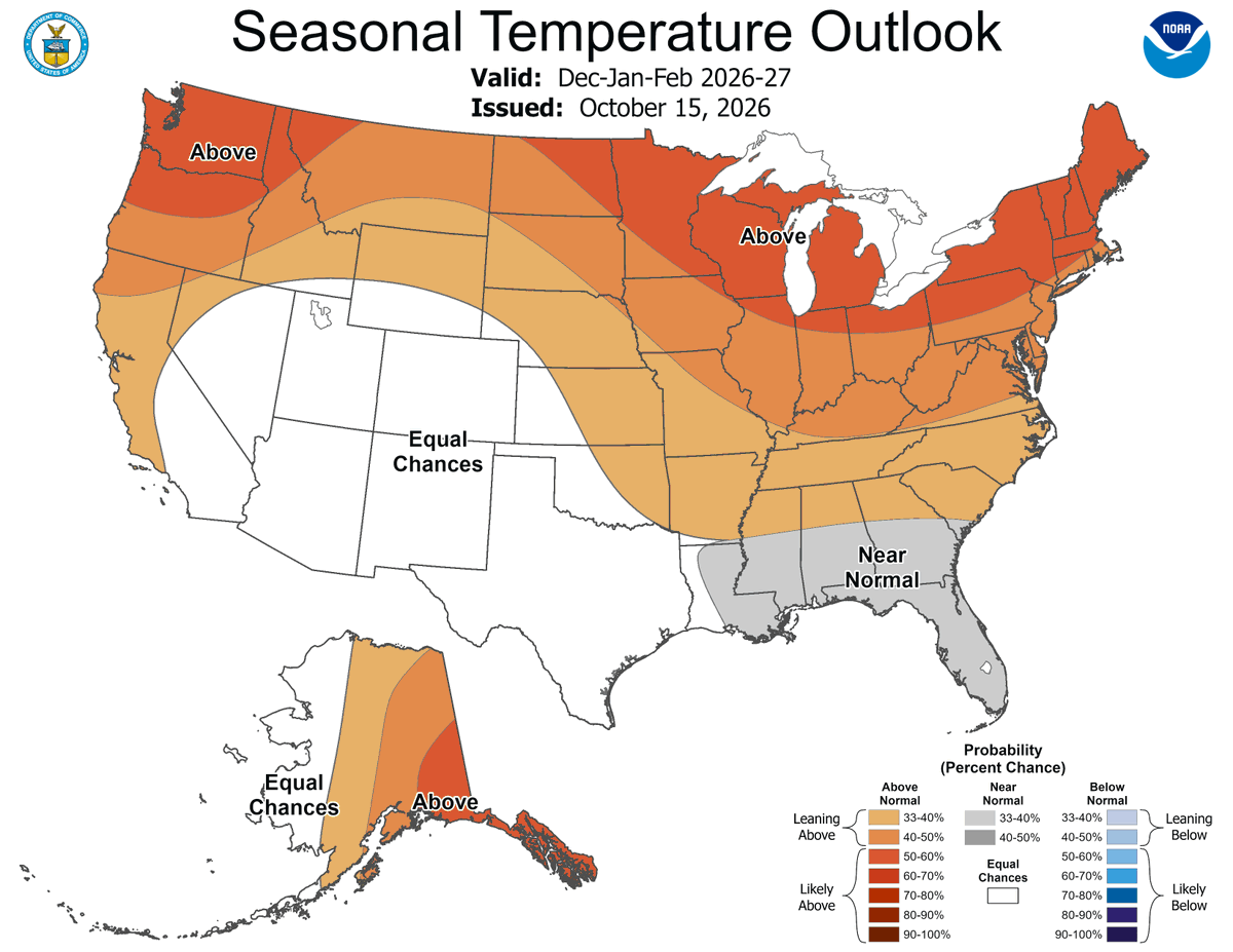
Just in: NOAA’s U.S. Winter Outlook calls for warmer-than-average temperatures for much of the northern tier.
What conditions could you expect in your hometown?
Find out more at https://t.co/A4JOnVdtCe
Via @nws@NWSCPC#WinterOutlook#Winter
Trump Administration issues America First Seafood Strategy to strengthen U.S. fisheries, processing capacity and coastal economies
News release: https://t.co/wX5raRSwa9
@NOAAFisheries#Seafood
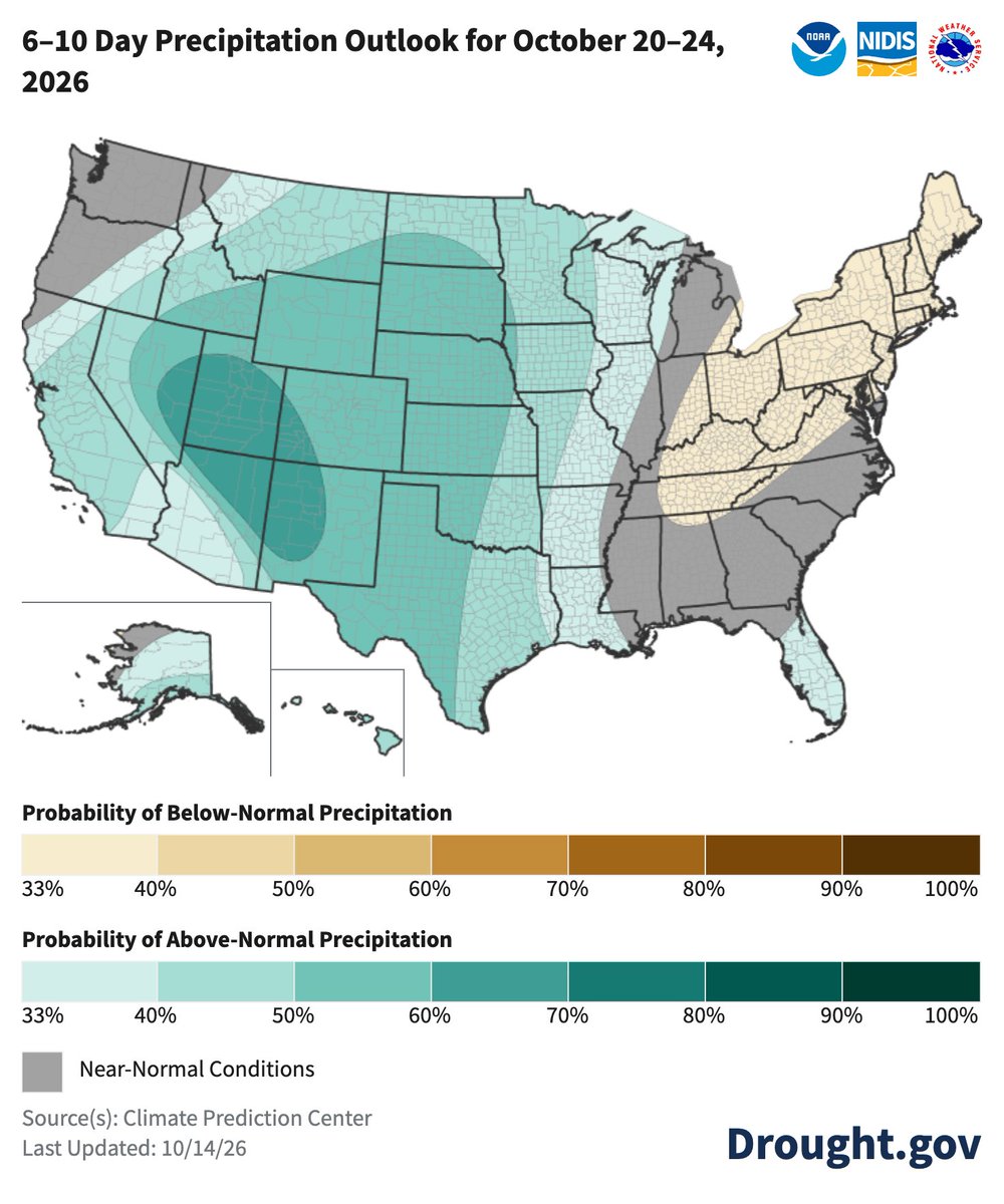
Next week leans relatively wet for much of the US, especially California, the Southwest, Texas, and Alaska. The Northeast, Mid-Atlantic, and a bit of the Northwest lean drier.
Temps: Warmer than normal likely for most of the US. Cooler in the Northwest + surroundings. @NOAA@NWS
Drought has worsened in the Upper/Lower Midwest
In early Oct, MI reached Exceptional Drought (D4) for the 1st time. WI entered D4 for the 2nd time. S. MO is also dealing with D3/D4.
Impacts: fires in N. MI, reduced alfalfa yields in WI, low livestock water supplies in MO. @NOAA
#DroughtMonitor 10/20: Widescale improvements for the Four Corners states and S. Plains. Scattered improvements in the Southeast and Northeast.
Widescale degradations again in the Lower Miss River Basin.
#Drought2026’s Footprint: 42.5% of the USA
https://t.co/6vjmufSaB2 @NOAA
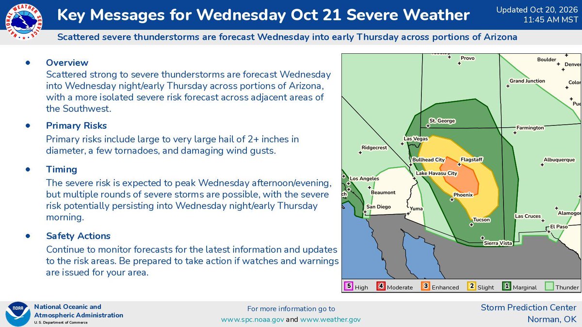
Severe thunderstorms including large hail and tornado risks are expected on Wednesday especially across Arizona and nearby parts of the Four Corners area and Lower Colorado River Valley. A localized severe risk may also exist along the coast of central/southern California.
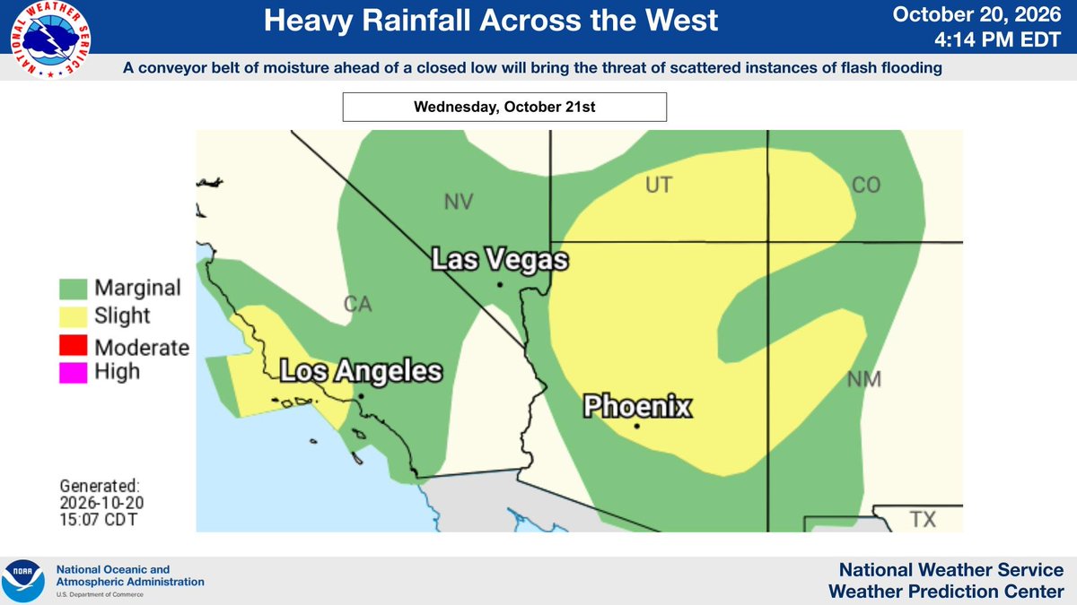
A strong Pacific weather system will bring a deep surge of moisture to the southwestern US Wednesday and Thursday, with periods of widespread showers and thunderstorms expected. A Flood Watch is in already effect for Wednesday and Thursday in much of Arizona. Monitor https://t.co/qk3BcVP5M8 for the latest.
A closed low and associated moisture conveyor belt (PWATS 3-4 standard deviations above average) will bring a level 2/4 flash flooding risk. The mountain ranges, especially burn scars, of Southern California to the Four Corners region will see heavy rainfall (1-2 inches).
Instead of just one number, local NWS Weather Forecast Offices offer winter pages showing the full range of potential snow & ice scenarios, from low to high end! Find your local page here: https://t.co/JIRulR5jxB, and learn how to use the data: https://t.co/ogtvJmi3a5 .
A developing Nor'easter is forecast to create hazardous marine and coastal conditions along the Mid-Atlantic coast through mid-week. Here are the latest Key Messages from the Weather Prediction Center.
Santa Ana winds will continue to impact southern CA through Saturday. Visit https://t.co/qk3BcVP5M8 for your latest local forecast updates! Santa Ana winds are strong downslope winds that blow through the mountain passes in Southern California. They are created over the Great Basin region from high-pressure air masses, which then blow down towards sea level. These winds, which can easily exceed 40 miles per hour, are warm and dry, and can severely exacerbate brush or forest fires, especially under drought conditions.
Strong winds will continue to develop tonight and persist into the weekend across southern California to Texas. Check https://t.co/qk3BcVP5M8 for the latest warnings and advisories! The loop below shows the forecast wind gusts this afternoon through late Friday night. High winds can be dangerous! If possible, stay inside. When driving, slow down, keep both hands on the wheel, and keep away from high-profile vehicles. Be aware of loose outdoor items and stay clear of trees. https://t.co/5RSiEeKct9
#DroughtMonitor 10/13: The Lower Miss, Lower Midwest, and SE TX continue to miss out on precip and worsen.
Hurricane Isaias improved drought in the Southeast. N. TX, Southwest, and N. Rockies improved too.
#Drought2026's Footprint: 45.0% of the USA
https://t.co/6vjmufSaB2 @NOAA
Next week leans wet for the West (especially the Southwest), Plains, and into the Miss River Basin. AK/HI too. Drier for the Northeast, Mid-Atlantic, and into the Ohio River Basin.
Temps: Cool for much of the Far West. Warmer than normal likely for most of the rest. @NOAA@NWS
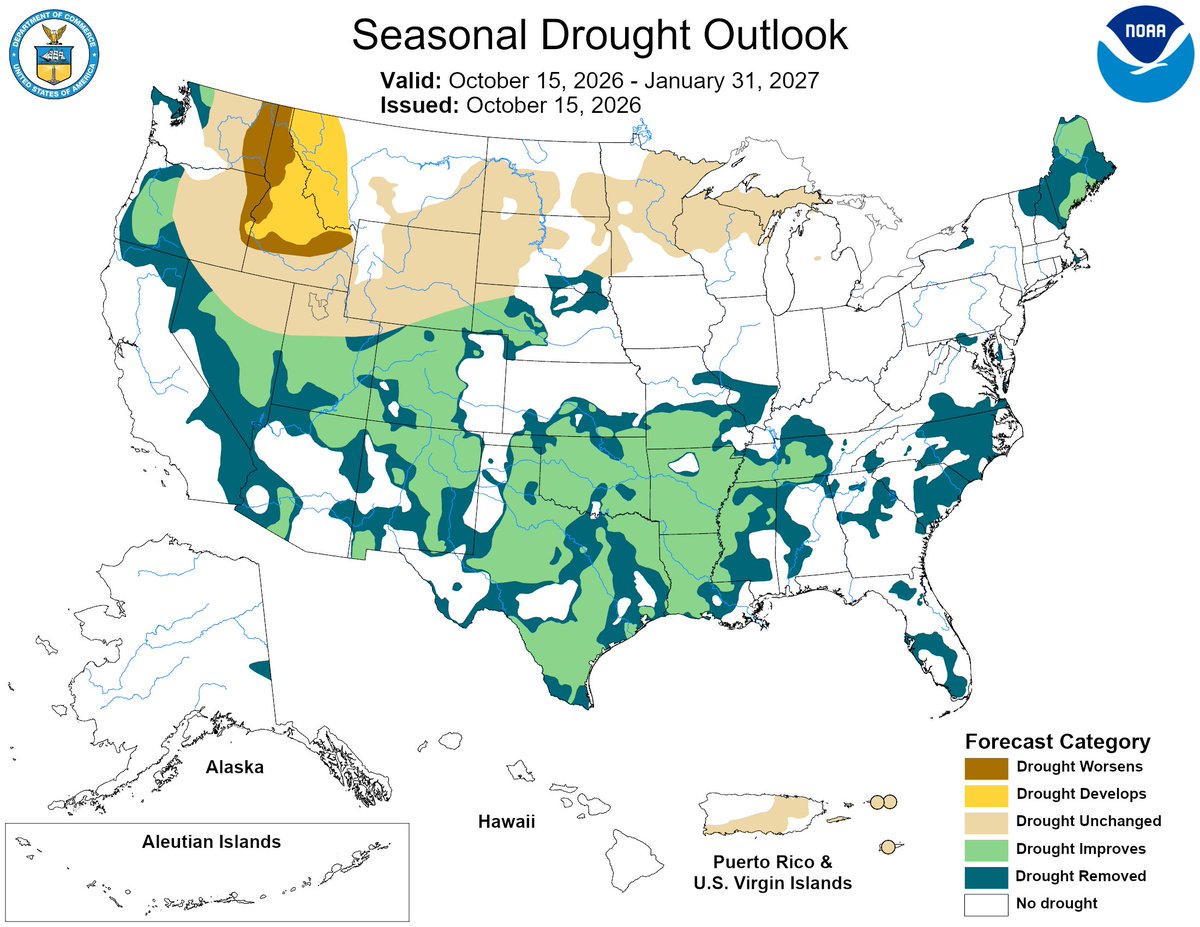
2/4 @NIDIS and @NWS are rolling out these updates to the U.S. Drought Outlooks to make forecasts clearer and more actionable.
Grounded in social science research, the redesigned maps feature clearer categories, simplified colors, and streamlined text for faster decision-making.
1/4 New Seasonal Drought Outlook with new design by @NOAA's @NWSCPC and @NIDIS
Drought develops/worsens: Interior Northwest and N. Rockies
Drought improves/removed: Southern US, Northeast, Coastal Northwest, a few others
Otherwise, drought persists https://t.co/7HFaZBslcS @NWS