We are now hiring early-career meteorologists at most offices across the country! Through an improved, streamlined hiring process, eligible candidates will be entered into pools to be continually considered for vacancies.
Interested? Here’s what you need to know:
➡️This large hiring push is split between offices in the following three vacancy announcements on USAJobs:
Possible recruitment incentives: https://t.co/QsQFodyqYh
Eastern: https://t.co/d3x1bqRxM5
Western: https://t.co/wvdgP9iURI
✅ You can apply to each vacancy group
✅ You can select multiple locations for each announcement
📝Applicants will be evaluated using a USA Hires assessment that could take 1-3 hours to complete, so plan accordingly!
⏳Closes September 30, 2026 - but apply early to increase your chances!
The first true heat wave of the summer will arrive next week across much of the Central and Southern Plains, eventually making its way to the east coast towards the end of the week.
A Red Flag Warning is issued when critical fire weather conditions are happening or about to happen. It does not necessarily mean there is a fire, but that conditions will be very dry and windy. If a fire is present, it can become extreme! Avoid activities that could spark a wildfire!
Red flag warnings are currently active across portions of the West. Check https://t.co/qk3BcVP5M8.
🌬️Higher-res models show that stronger outflows from thunderstorms in New Mexico are capable of producing wind gusts up to 35 mph this afternoon & evening. These winds, particularly near San Simon along I-10, are capable of lofting areas of blowing dust. Stay weather aware! #azwx
Severe thunderstorms which can bring large hail, damaging winds, and isolated tornadoes will be possible over parts of the central U.S. through this weekend.
Thunderstorms with heavy to excessive rainfall moving from Texas into the mid-Mississippi Valley through this weekend may produce areas of flooding.
Be sure to stay up with the latest forecast at https://t.co/qk3BcVP5M8.
Scattered severe thunderstorms capable of large to very large hail, damaging winds with potentially significant gusts, and perhaps a couple of tornadoes are expected Friday afternoon into night across portions of the central Plains into upper Great Lakes. Thunderstorms with heavy to excessive rainfall may produce flooding over a part of the Midwest Friday. https://t.co/qk3BcVP5M8
Heat will build across the East Coast into the weekend as high temperatures will approach the low to middle 90s. Widespread Moderate to isolated Major Heat Risk are in the forecast. Stay hydrated and avoid activity in the middle of the day.
The threat of flooding today will shift a bit as we get into Friday, impacting areas of far eastern Nebraska, southern Iowa, far northern Missouri, and northwestern Illinois. Keep up with the latest at https://t.co/qk3BcVP5M8, and if you encounter a flooded road, Turn Around, Don't Drown.
Severe thunderstorms capable of large to very large hail and damaging winds are possible today from parts of the northern High Plains across northern Nebraska and much of South Dakota. More isolated occurrences of large hail and damaging winds appear possible farther south across portions of the central Plains. https://t.co/qk3BcVP5M8
Severe thunderstorms capable of large to very hail and damaging winds are possible from parts of the northern High Plains into lower elevations of the northern and central Plains Thursday afternoon into night. Thunderstorms with heavy to excessive rainfall may produce flooding over a part of the Midwest Thursday. https://t.co/qk3BcVP5M8
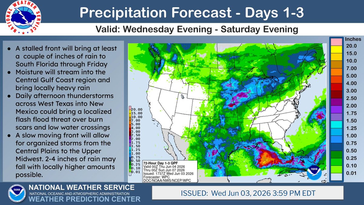
The next 3 days will feature an early Summer like pattern with locally heavy rainfall possible for South Florida and the Central Gulf Coast. Localized flash flooding will also be possible from the Southern Plains to Midwest with plentiful moisture ahead of a slow moving front.
The eastern Pacific Ocean has kicked off its tropical season with Tropical Storm Amanda. No threat to land, Amanda is forecast to strengthen in the coming days before weakening to a remnant low later this weekend into next week.
https://t.co/meemB5vfqp
Thunderstorms with large hail, severe wind gusts, and a few tornadoes will be possible this afternoon and evening in parts of the northern Plains into upper Mississippi Valley. Visit https://t.co/VyWINDk3xP for details.
June 3 8AM PDT- The first tropical storm of the Eastern Pacific Hurricane Season has formed #Amanda. Strengthening is expected over the next couple of days, before a weakening trend this weekend.
An X1.0 class (R3 - Strong) occurred at 11:28 UTC on 03 June, originating from Region 4455, the same region that produced the M9.3 and M7.7 earlier in the UTC day. There is a 9% chance of a particle event from this R3.
Severe thunderstorms will be possible over parts of the northern Plains again Wednesday which could bring large hail, damaging winds, and possible tornadoes. Thunderstorms with heavy to excessive rainfall may produce flooding over parts of the southern and northern Plains Wednesday. https://t.co/qk3BcVP5M8
The work of hydrologists in our Operations Division is vital to translate complex data into life-saving information. These scientists and technicians at the National Water Center and 13 River Forecast Centers help keep our nation #WeatherReady.
6/2 2pm PDT: Tropical Depression #One-E has formed over the open waters of the East Pacific. Although some strengthening is forecast, it does not pose a threat to land. Check https://t.co/Oy8uoeRKme for the latest updates.
Latest SWPC video update regarding sunspots, magnetic flux emergence, and eruptive events. And, just 5 minutes or so after recording this video, an M3 (R1) solar flare occurred right from that emerged flux! Check out the video to learn more!