The answer is FALSE! 🚫🚙
If you can't get indoors, a metal car IS a safe shelter, but it has nothing to do with rubber tires.
It acts as a "Faraday cage." The metal frame conducts the lightning safely around the outside of the vehicle and into the ground.
⚡ LIGHTNING MYTH OR FACT? ⚡
True or false: An enclosed, metal vehicle is a safe shelter during a lightning storm because the rubber tires insulate you from the electrical charge. #azwx
(Cast your vote below! Answer in the thread 👇)
Strong to locally severe thunderstorms are expected over Yavapai & Gila counties during the mid-late afternoon on Sunday. Gusty outflow winds of 30-50 mph are likely with the storms, with isolated gusts to 60 mph. #azwx
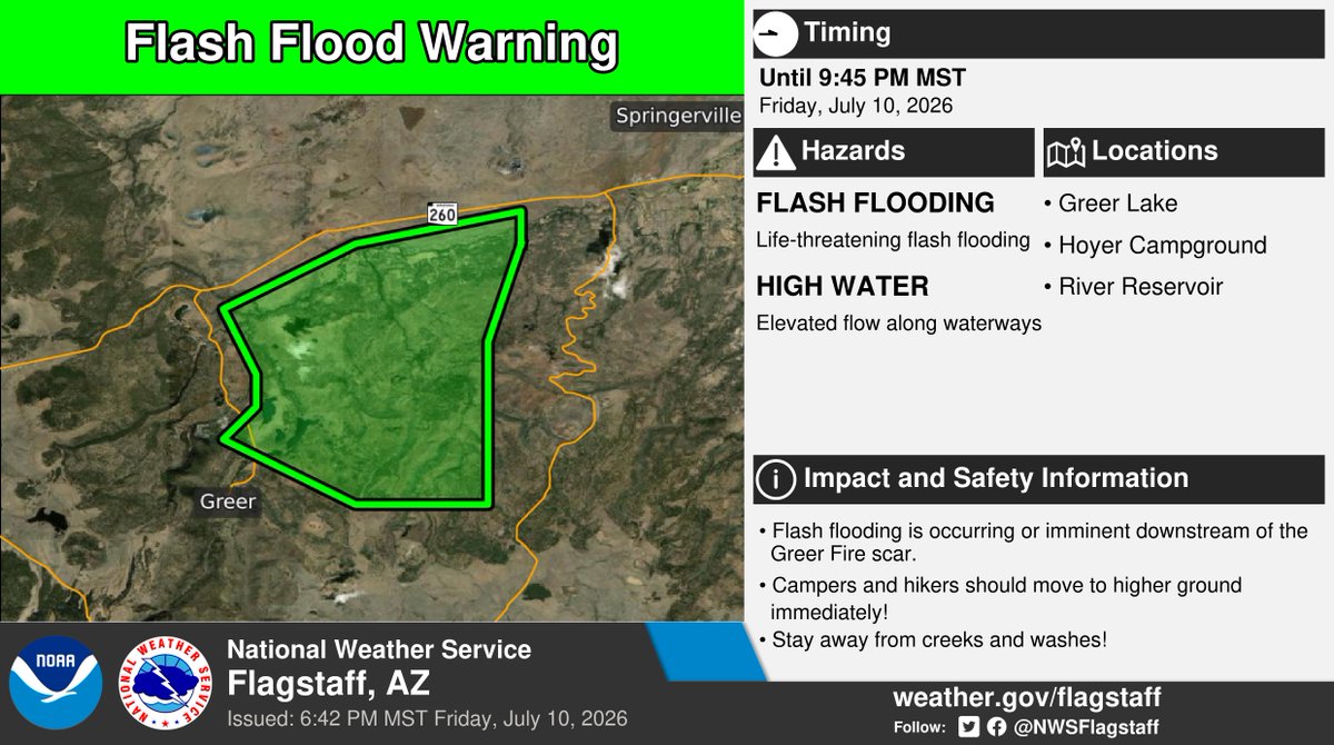
⚠️ Flash Flood Warning ⚠️ in effect until 9:45 PM MST for portions of Apache County.
This includes Greer Lake, Hoyer CG, and River Reservoir. More info: https://t.co/jTdNjRf7om. #azwx
Quiet conditions stick around for Fri/Sat with only isolated high-country storms. But a monsoon moisture surge begins Sunday, leading to active, widespread showers and thunderstorms across northern AZ by Monday! Stay weather-aware early next week. #azwx
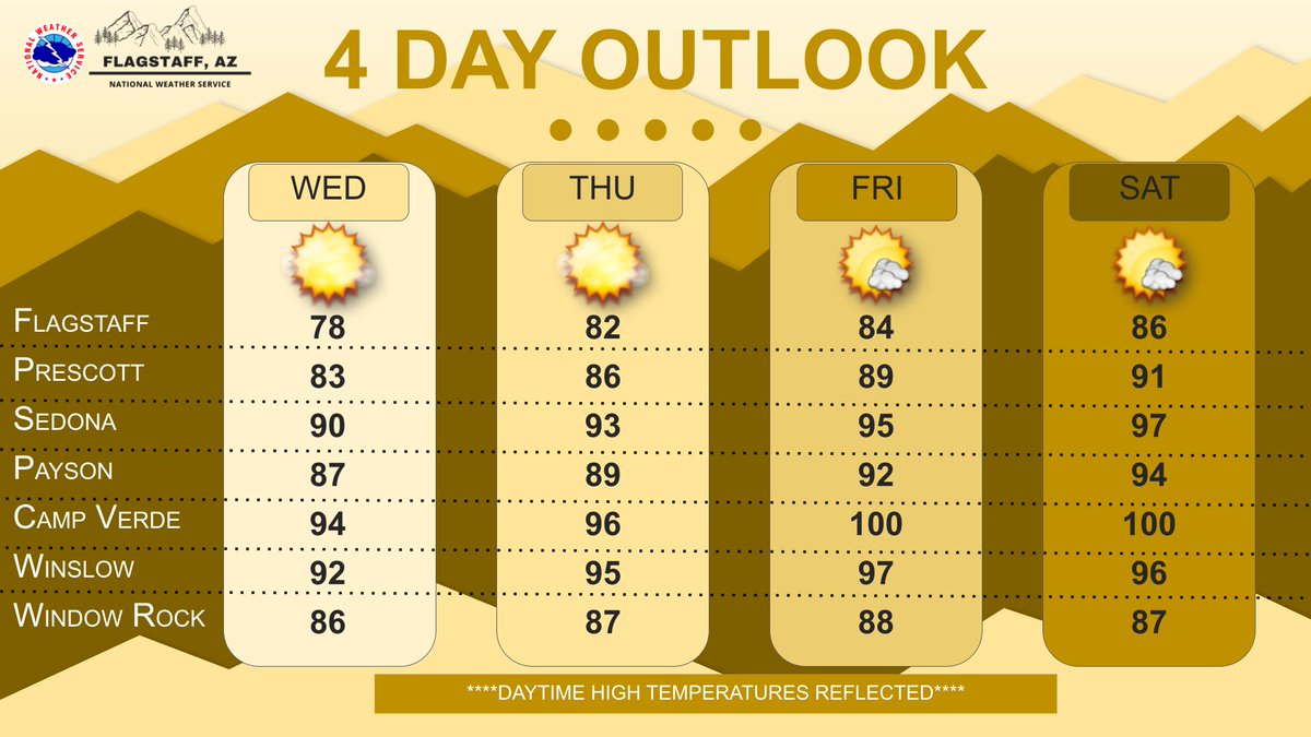
Shower and thunderstorm chances have been pushed eastward for the next few days, the White Mountains still have a chance. This allows the hot temperatures to be the main story. Rain chances return over the weekend, Monsoon 2026 will be in full swing by Sunday or Monday. #azwx
An Extreme Heat Warning remains in effect for the Grand Canyon below 4000 ft through Sunday and for Marble/Glen Canyons & Page for Saturday & Sunday. #azwx
Expect another day of active weather generally east of I-17 and south of I-40 today. Things dry out a bit Thursday and Friday, but ramp back up over the weekend, as Monsoon 2026 gains a significant amount of steam heading into next week. #azwx
Believe it or not, there were some showers and thunderstorms around yesterday and there will be more today. The best chance over the next few days will be across southern Navajo and Apache counties, maybe a bit farther west each day. Then, a bit drier to end the week. #azwx
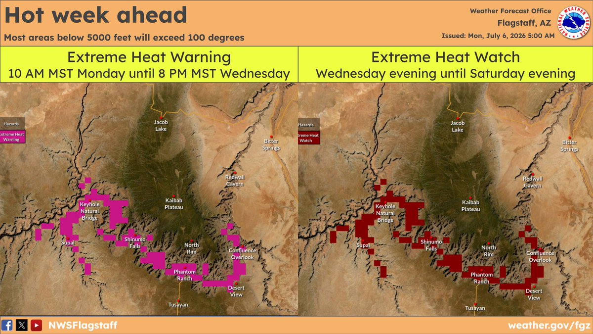
Areas below 5000 ft in AZ will exceed 100 degrees this week, with temperatures pushing 110+ degrees below 4000 ft. The Extreme Heat Warning for the Grand Canyon below 4000 ft is in effect through Saturday. Daytime hiking at lower elevations is discouraged due to the heat. #azwx
It's going to be a hot week, yes, it is July, but you will feel it. Most areas below 5000 feet will exceed 100 degrees, with temperatures pushing 110 degrees below 4000 feet. Be careful out there. #azwx
Temperatures will warm significantly this week, likely to the warmest readings all year. For those headed to the Grand Canyon, an Extreme Heat Watch is in effect from Tuesday morning until Saturday afternoon for elevations below 4,000 feet. #azwx
Most locations will be dry with seasonably warm temperatures. The higher terrain may see a 10-20% chance of an afternoon shower or thunderstorm as some moisture makes its way into the state. #azwx
Some moisture will move in from the south Saturday/Sunday. While most areas will remain dry, there is a slight chance of some light showers and possibly an afternoon thunderstorm. The main threats with this activity will be gusty outflow winds and a few lightning strikes. #azwx
Daytime highs warm up to near normal for this time of year, along with dry conditions and breezy winds Friday and Saturday. By Sunday some moisture moves into the area bringing a 10-20% chance of an isolated thunderstorm over the highest terrain. #azwx
The forecast is shaping up nicely for the Holiday Weekend! Expect temperatures in the 80s/90s for much of northern Arizona, with winds out of southwest at 10-20 mph. #azwx
Here's a link to the latest smoke outlook for the Pocket Fire https://t.co/OUCEha3omO Also shown here is a model forecast of smoke through Thursday afternoon. #azwx
July 1st freeze for parts of the high country. Dry air and light winds combined to bring the chilly temperatures. A refreshing 28.6F here at NWS Flagstaff. #azwx
Dry and breezy conditions will continue through the end of the week, before lighter winds return for the Holiday Weekend. Temperatures will remain below normal for the next few days, becoming near normal for this time of year by the weekend. #azwx