Waves of rain repeatedly slamming into the Eaton Fire burn scar.
The soils are absorbing it like a champ. Almost zero reaction from the creek downstream despite rain all day.
The 2026 fire season is being wiped out in Los Angeles County as we speak. It'll take weeks to dry out.
Some pretty remarkable daily rainfall totals are occurring in the LA basin rn, with many areas approaching or exceeding 1” of rain. These rainfall totals are seen more often during the peak rainy season (Dec-Mar), not in early September.
While some minor flash flooding has occurred in the area, the good news is that fire danger will likely be lower than usual for a while, and perhaps for the rest of 2026 in the LA region.
Will moisture from tropical storm Marie impact CA’s central coast and the SF Bay Area?
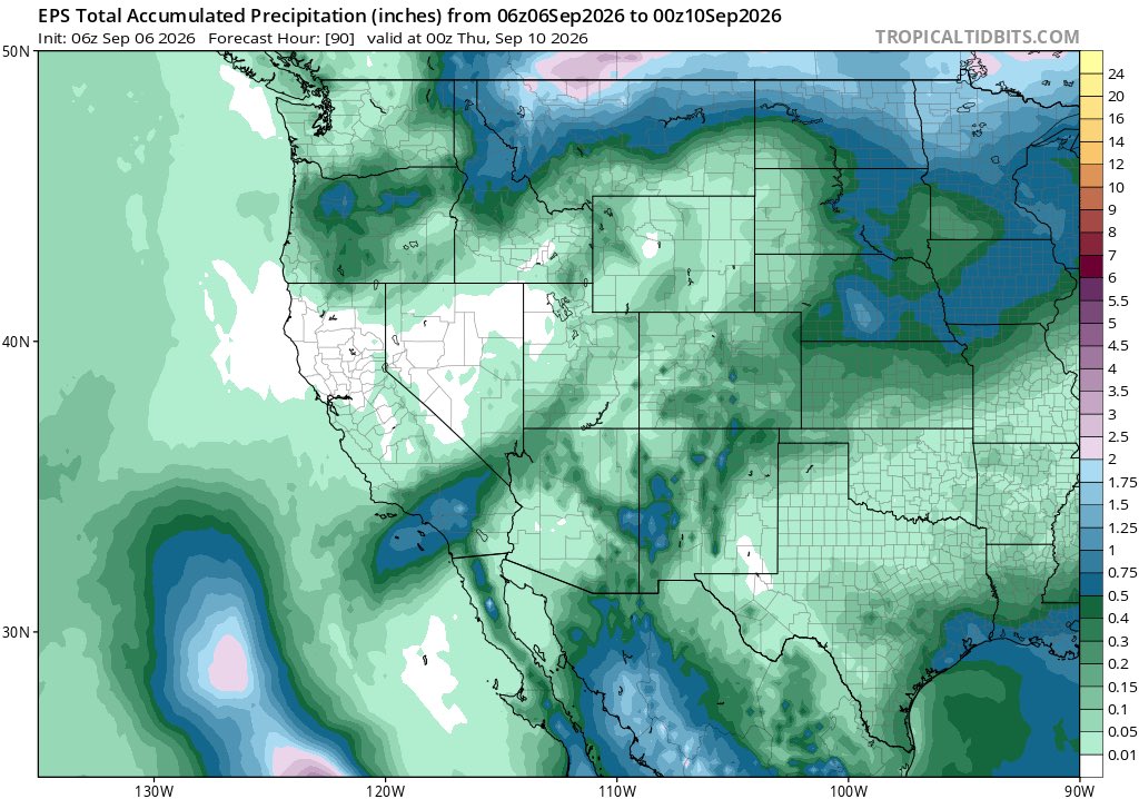
First of all, it’s very unlikely there will be a widespread moderate to heavy rain event like what Los Angeles is experiencing now. However, the chance that small amounts of precipitation makes it to the regions isn’t zero. Precipitation is unlikely north of I-80, since the tropical system is expected to weaken significantly before the most anomalous pulse of moisture makes it to that region. Right now, the European ensembles mostly consist of solutions that don’t bring significant precipitation to the Southern SF Bay Area and the Central Coast of CA, while a few (minority) of them bring scattered showers and thunderstorms with modest precipitation totals.
Here’s what caught my attention. The same (Euro) ensemble also suggests highly anomalous precipitable water anomalies (PWAT) over those regions, with many locations showing 4-5 standards deviations above the mean around noon on September 9. The previous several tropical moisture surges (In July and August) saw less anomalous PWAT’s in the region (more like 2-3 standard deviations above the climatological mean), and did produce a few light showers in the area, and a few spots saw measurable rainfall. Additionally, July and August are on average even drier in the Bay Area than September, meaning the projected 4 sigma anomaly comes from a higher precipitable water average than the July-August events.
Does this mean those regions will see rain and thunderstorms? No. But it’s very unlikely that such anomalously high PWATs would coincide with no precipitation at all. It’s likely that either the PWATs are being overestimated or the precipitation amounts are being underestimated. It’s hard to tell which one is more likely true.
Regardless, there are some weather-related impacts I’d watch out for next week in the Bay Area. Temperatures will likely be in the 80-90 F range near the coast (80 F could be reached in the usual cool spots like Monterey or SF), while inland areas could see 90-100 F temperatures from Tuesday to Thursday (Wednesday will likely be the hottest day). Nights may end up anomalously warm, as many non-immediate coastal Bay Area regions could see nights that fail to fall below 70 F, which is very unusual. Additionally, with the surge of tropical moisture likely, humidity could be unpleasantly high, making 90 F feel more like 100 F.
Whether showers/t-storms occur in the area on Wednesday is still uncertain, and we probably won’t know for another 24-48 hours. Stay tuned for more updates.
Update for 9/5: Precipitation in SoCal looks a bit less intense in terms of rain rates, so debris flow risk now appears low. There could be heavier downpours if thunderstorms develop, but it doesn’t look like a hazardous event.
If anything, the precipitation will likely be beneficial and temporarily decrease wildfire risk.
UPDATE ON HURRICANE MARIE:
Just a few days ago, the debate was whether Marie would move far west, bringing few to no impacts to California, or would it move east and possibly impact SoCal as a tropical cyclone. Since we’re now closer to the event, we have a bit of a better idea of where Marie is going to head towards, and it appears to be somewhere in between (it’ll likely move to the north-northwest).
What does this mean for California in the coming days? The odds of the state being directly hit by the tropical cyclone is almost negligible. However, some indirect impacts look pretty likely, especially for SoCal. From Saturday evening (9/5) to Sunday (9/6), scattered showers and thunderstorms may develop in the Los Angeles area as a result of Marie’s moisture being advected northward. In fact, some recent ECMWF runs show localized torrential downpours from thunderstorms in the region. To be clear, despite the chance of heavy rainfall, this does not mean every location will experience it. This is a convective weather event, not a widespread rain event like what tends to occur in winter storms, so it’s almost certain that parts of LA will be mostly missed by the storms while the wettest spots could experience rainfall totals of 0.5-1” or more.
There are some hazards that may occur as a result of these storms. Flash flooding will be possible under heavier showers and t-storms, and I’m also slightly concerned about debris flows in wildfire burn scars from January 2025 (especially in Altadena where the mountains are very steep). If you are in one of the areas that were near a recent wildfire (past couple of years), please stay aware of weather updates this weekend as these showers/t-storms develop. Is it guaranteed there will be debris flows? No, but it’s something worth watching if heavy t-storms were to develop over those burn scars. Additionally, general thunderstorm hazards will be possible in SoCal such as lightning and gusty winds. More information will come out about this weather event in the next 24-36 hours.
This rain will be mostly light to moderate, with only a few local heavy downpours in thunderstorms. Thus, this will be mainly beneficial rainfall--little flood risk, but also low dry lightning (wildfire) risk. Large waves/strong surf is likely at beaches, though, so be careful!
@PicturesFoIder To clarify, it’s still theoretically possible for Earth to return to the pre-industrial climate (depending on a number of things), but certain ecosystems wouldn’t be the same after experiencing 1.5 C of global warming in an unusually short time.
@SoCalweathernet@BrunelShawn Idk if I’d describe the forecast as prolonged light to moderate rain. This event seems pretty scattered and convective, so I think it’s more likely some locations will see very little to no rainfall while other areas (under heavier, convective downpours) will see 0.5-1”+.
@chrishe10347730@RobMayeda If it rains in October I’d say it’s virtually a guarantee. I can’t imagine a November or December in a super El Niño being a complete shutout.
@chrishe10347730@RobMayeda I remember last year it rained on September 10 in San Jose, which I thought was as early as front-based rain could possibly get. Somehow this year beat it.
On Friday, 9/4 at 10am PT, I'll have a another live Hurricane Maria-focused update on YouTube. I'll share the latest on the forecast evolution, answer your questions re: tropical storms/hurricanes and California weather, and try to dispel some myths. https://t.co/Gms9DS4kSq
@NWSBayArea It’s rare for the first widespread rain of the season to occur in early September, especially from a cold front rather than a subtropical moisture event.