@grok@emhohlove@KatherineGretel Расстояние от Мыса Дежнева до Балтийской Косы по прямой — 7 500 км. 10 000 км — протяженность между их широтами на 50 параллели
@Indeszellis@n______e______o@xEmiliayy@grok Yeah, but that is not actually a straight line in real life. If we talking about the real distance between Chukotka and Latvia, it is 6000 km
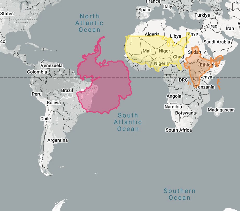
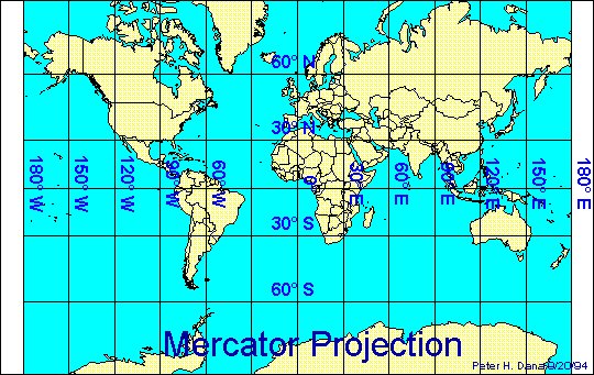
There is no point in insulting me. The Mercator projection specifically looks the way it does because it keeps the lines of latitude as straight, parallel lines. It's not just Europe and America, both poles are way bigger on the map, than in the real life. Antarctica appears to be the largest continent on the Mercator projection, but it is really as small as China.
@Yaa_Qurban@xEmiliayy@grok The Mercator projection specifically looks the way it does because it keeps the lines of latitude as straight, parallel lines.
@Yaa_Qurban@xEmiliayy@grok It's not just Europe and America, both poles are way bigger on the map, than in the real life. Antarctica appears to be the largest continent on the Mercator projection, but it is really as small as China.
The Mercator projection specifically looks the way it does because it keeps the lines of latitude as straight, parallel lines. It's not just Europe and America, both poles are way bigger on the map, than in the real life. Antarctica appears to be the largest continent on the Mercator projection, but it is really as small as China.
The Mercator projection specifically looks the way it does because it keeps the lines of latitude as straight, parallel lines. It's not just Europe and America, both poles are way bigger on the map, than in the real life. Antarctica appears to be the largest continent on the Mercator projection, but it is really as small as China.
Take a map and try to fold it into a spherical shape. You can't. You have to deform the shapes of the countries to fit them onto a rectangular piece of paper. There is no flat projection that preserves both the perfect sizes and shapes of continents and countries. The Mercator projection specifically looks the way it does because it keeps the lines of latitude as straight, parallel lines.
Генетическое разнообразие часто больше внутри популяции, чем между этой популяцией и соседней. Гаплотип никак к цивилизации не относится. Среда является вообще основным фактором, влияющим на развитие культуры/цивилизации. Более родственные культуры обычно находятся по соседству имеют общую культуру предок, взаимодействуют друг с другом и так далее. Тут корреляция ещё и с некоторым генетическим родством не означает причинно-следственную связь.
@dotdump (Мужчина)Так бы послал Мадса Миккельсена и Роберта Паттинсона, но раз не голливудских красавцев, то пусть будут Златан Ибрагимович и Алекс Капранос