We recently demonstrated SUVI to the @IndiaCoastGuard Southern Coast Guard and Coastal Police, validating how persistent aerial monitoring performs in real-world maritime environments.
India’s coastline spans over 11,098 km, making constant maritime surveillance a massive challenge. SUVI supports coastal units by extending visual coverage and providing continuous aerial tracking over wide maritime zones. During the live demonstration, real-time video feeds provided ground teams with immediate visibility over distant waters.
The UAV used for this demonstration was SUVI, India’s first DGCA Type Certified sub-10 kg solar-electric platform. Designed as a compact, hand-launchable system requiring zero runway infrastructure. It offers key operational advantages in the field.
Powered by integrated solar-electric technology, SUVI delivers up to 7 hours of continuous flight endurance and an operational range of 50 km. Allowing the ground teams to cover expansive coasts, eliminating the disruption of constant landings and battery swaps. The platform features a fully interchangeable payload system. Operators can rapidly swap cameras and specialized sensors in the field depending on the mission profile.
Beyond routine coastal watch, teams can track illegal fishing, smuggling, and unauthorized crossings across high-risk boundaries, day or night, without putting personnel in harm’s way.
The same platform adapts just as seamlessly to urgent emergency responses. It can rapidly scan vast search grids across open ocean for search-and-rescue (SAR) missions, while also monitoring offshore infrastructure and environmental threats like water pollution.
SUVI stands ready to empower coastal defense and security units across diverse operational challenges. For a detailed breakdown of SUVI’s specifications and system architecture, access our product brochure here: https://t.co/ZaDCIhwkYM
#MaritimeSurveillance #CoastalSecurity #AerialMonitoring #UAV #SolarElectric #SearchAndRescue #BorderSecurity #EnvironmentalMonitoring #IllegalFishing #OperationalReadiness
@OkuloAerospace@Parithi_Aero@JavaCapital@IdeaspringCap@vcatsindia@IndiaCoastGuard@DGCAIndia
The recent flash floods in Jammu & Kashmir are a stark reminder of a recurring tragedy: when severe disasters strike, ground infrastructure is the first thing to fail. Power goes out, cell towers get knocked offline and entire communities vanish into communication blackout within minutes.
For first responders trying to navigate destroyed terrain and locate missing people, those initial hours are a desperate race against time.
This is precisely where High-Altitude Pseudo-Satellites (HAPS) can rewrite the outcome of a disaster response.
Operating high up in the stratosphere, far above storm clouds and completely independent of ground power, solar-powered HAPS can be quickly redirected over a crisis zone. In Jammu & Kashmir, where almost 44 cloudbursts have claimed around 35 lives, having this technology operational would have fundamentally changed the on-the-ground reality:
Instant Connectivity Restoration: Flying as a continuous floating cell tower, HAPS gives trapped families in isolated pockets the ability to send emergency SOS messages, while keeping rescue teams connected without relying on damaged ground networks.
Persistent Airborne Monitoring: Bad weather and cloud cover often blind conventional satellites. Because HAPS operates in the stratosphere, it is vastly closer to Earth than satellites and hence, delivers dramatically higher image resolution. Equipped with non-optical payloads that pierce directly through heavy clouds and darkness. HAPS provides continuous, day and night intelligence helping commanders spot survivors, track shifting terrain and guide rescue teams in real time.
When lives are on the line, every minute counts. By filling the gap between ground networks and space, HAPS gives emergency teams the clear, uninterrupted line of sight they need to save lives.
And disaster relief is just one of many vital applications transforming the future of stratospheric aviation.
Dive into how HAPS technology is transforming global connectivity, emergency response and environmental monitoring on the World Economic Forum’s strategic intelligence platform: https://t.co/fABN5SLOHO
#HAPS #DisasterResponse #JammuKashmir #EmergencyTech #Connectivity #StratosphericAviation #FloodRelief #RescueOperations #Innovation #GlobalMonitoring
We recently wrapped up a great experience at @larsentoubro 's Drone Manthan, where @OkuloAerospace was proud to be featured as one of only 21 selected startups.
Connecting with teams across various L&T subsidiaries gave us space to have meaningful discussions around real-world UAV applications, helping both sides uncover fresh ways this technology can be advanced.
Opportunities like these are a great reminder of how much potential lies in collaborative growth and we are excited to keep building on the connections made during the event.
Also, huge congratulations to the L&T team on unveiling their impressive new UAV, Vedh Mk1.
#DroneManthan #OkuloAerospace #LarsenToubro #UAVApplications #CollaborativeGrowth #VedhMk1 #AerospaceInnovation #StartupShowcase #TechNetworking #FutureOfDrones
At @OkuloAerospace , we are already building this infrastructure. Our solar-powered platforms are on track to make this sovereign capability a reality.
For too long, India’s industries and defense forces @adgpi have relied heavily on foreign space-tech infrastructure. However, that trajectory is changing as Indian defense forces are trying to become more independent.
Read the full breakdown on this massive shift below.👇
HAPS are solar-powered, ultra-high-endurance UAVs that we believe will become the cornerstone of earth observation and telecommunication infrastructure in the near future. This investment is a clear signal from our defense forces to build a truly sovereign earth observation stack
Reinforcing that vision, the Defence Acquisition Council has given administrative approval for procurements worth ₹52,000 Crore to strengthen India’s Airpower, including fixed-wing HAPS.
This can be seen in the recent release of The Indian Army’s technology roadmap for UAS and loitering munitions, signalling a deliberate shift towards next-generation warfare.
We are thrilled to share that we have successfully onboarded 40 new #deeptech#startups on their #nasscom dtc journey. With this being our largest onboarding to date, we have become a 300+ deeptech startup community with pan-India representation.
We are excited to announce that Okulo Aerospace is looking for an Electronics/Avionics Intern to join our team!
As an Electronics/Avionics Intern, you will gain hands-on experience in designing and developing electronic systems for UAV and drone applicat…https://t.co/IPsQyXdpI2
We are thrilled to announce that we have an exciting open position for a Fixed Wing Test pilot at Okulo Aerospace. As a drone test pilot, you will be, you will be responsible for testing and operating a wide range of unmanned aerial vehicles (UAVs) to cap…https://t.co/trCLwuESG8
Looking for experienced fixed wing and VTOL hybrid drone pilots to flight test the next generation of long endurance UAVs. Please tag or share with your network to those who might be interested in this opportunity.
#longendurance#uavs#drones#okuloaero…https://t.co/DdCYqqRWh4
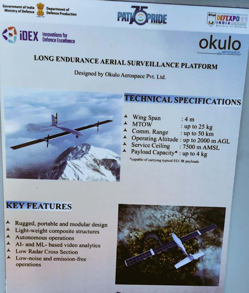
Long Endurance Aerial Surveillance Platform by Okulo Aerospace.
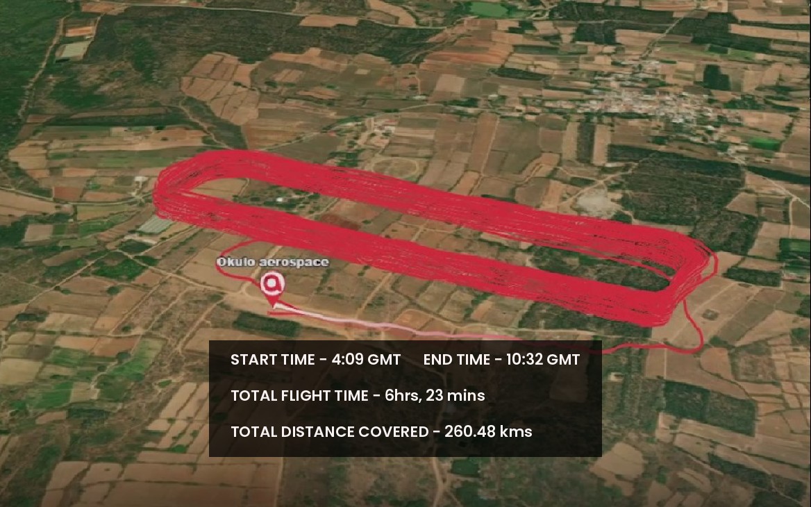
The firm had announced in Sept that its UAV had achieved 6 hrs 23 mins of endurance. That is great for such a small, low(ish) altitude platform (with pseudosatellite characteristics?)
Congratulations to the entire team at Okulo Aerospace! Improving #flighttime or #endurance is the holy grail of the #drone industry and we are continuously improving our products to provide #persistent aerial monitoring capabilities for several use cases.…https://t.co/JQIAlPzHbO