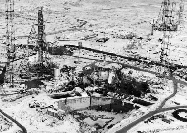
The New Glenn explosion created a highly asymmetric shockwave and directional fireball, subjecting the closer tower (the one that collapsed) to much more intense thermal and overpressure forces.
Reuters confirmed a structure at the entrance of the hotly disputed Scarborough Shoal in the South China Sea last week, though later imagery suggests it is no longer there.
The New Glenn explosion created a highly asymmetric shockwave and directional fireball, subjecting the closer tower (the one that collapsed) to much more intense thermal and overpressure forces.
The New Glenn explosion created a highly asymmetric shockwave and directional fireball, subjecting the closer tower (the one that collapsed) to much more intense thermal and overpressure forces.
A new high resolution satellite image shows the Blue Origin's New Glenn launch pad following the rocket's explosion a few days ago.
The largely damaged launch site can be clearly seen in detail.
View and compare: https://t.co/OjX7XWHFuT
Large VLCC spotted TODAY loading crude oil in Iran 🇮🇷 Jask Terminal at
25.8440, 57.2436
Oil comes via Goureh-Jask 1,100 km onshore pipeline from southwestern Bushehr Province. Offshore loading single buoy moorings allow massive oil tankers to load cargo directly in deep water.
Back on March 25, 2026, satellite imagery showed black smoke rising over Kuwait International Airport following a drone strike. The incident shows how exposed critical civilian infrastructure is.
Explore and Compare: https://t.co/P8crYrKi9M
#MiddleEast#IranWar#Iran
This looks like a mirrored damage pattern. A central core of severe thermal damage around the refinery tank area, with symmetric secondary damage extending outward. #oott
Additional reconnaissance of the strike on the Ryazan Oil Refinery on May 15. New details on the damage
New higher-quality satellite images have captured additional damage that was not visible in earlier imagery.
I just found the French aircraft carrier Charles de Gaulle (R91) on Sentinel-2 satellite imagery, 24/05/2026.
It is currently sailing in the Arabian Sea, escorted by a single destroyer.
Coordinates: 16.83654, 55.92432
@FaytuksNetwork@MenchOsint@EGYOSINT@GeoConfirmed
This Memorial Day, we pause to honor those who gave everything in service to our country. 🇺🇸
To every family carrying a name today, we remember them with you, and we are grateful.
@KyleJGlen True. Also, the Sheskharis terminal sits amid steep Black Sea coastal valleys. So that smoke and heat from even a small fire gets trapped by the terrain. Makes a localized hotspot look much bigger or shifted on the FIRMS map.
Back on March 7th, 2026, Satellite imagery confirmed extensive destruction across key naval facilities at Bushehr, aimed at degrading Iran’s ability to sustain naval operations.
Explore and Compare: https://t.co/yU2g3wNTwq
#MiddleEast#IranWar#Iran
The Grushovaya oil terminal is (was) a major oil depot near Novorossiysk, part of the Black Sea export chain linking Russian pipeline-borne oil to coastal export terminal infrastructure.
Location (44.749098, 37.878696)
I did celebrate too early. Sunk Iran drone mothership SHAHID BAGHERI 🇮🇷 spotted TODAY 👇 surrounded by black oil slicks indicating severe leaking. POSS due to some new bunker fuel tank breach.
She´s laying on the bottom between Qeshm Is. and Bandar Abbas.
#oilspill#persiangulf
Localized burn scar along the side of the long blue-roofed structure and into the equipment area. Some dark tank tops are just normal roof residue staining and not damage. #oott
Following reported Iranian drone strikes and a separate industrial fire at the Fujairah Oil Industry Zone in recent months, SkyFi tasked satellite imagery to provide updated visual context of the area.
The image captures key infrastructure across the zone, including industrial facilities, storage tanks, and the surrounding terminal area, helping analysts build a clearer picture of conditions on the ground.
For energy, defense, insurance, logistics, and risk teams, this is the value of rapid satellite tasking:
A verifiable visual layer while the situation is still unfolding, and a better understanding of downstream impacts.
🇷🇺 Ryazan fire spotted TODAY 👇 Ukraine 🇺🇦 long-range drones struck Rosneft refinery overnight, igniting a massive, multi-hotspot fire at one of Russia's largest fuel processing facilities.
Critical vacuum distillation units fire reported; POSS at
54.5655, 39.7406, left inset.
@EpochAIResearch Can I DM you about this? I've been tracking these buildouts for a while, mostly through grid/substation clues and construction progress. Really glad to see someone approaching this systematically. Happy to share notes.