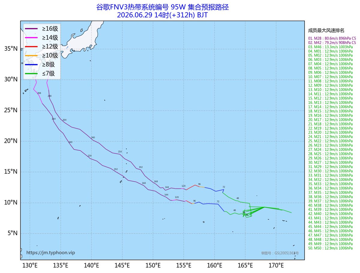
Regardless, #09W (likely to be named Bavi), is expected to become a very powerful typhoon over the coming days, with the JTWC now forecasting a super typhoon (135kts) by Sun. (Mon. CHST).
Previous update on 09W on my YT Channel down below!
https://t.co/9VyqRWUjgW
#guam#saipan
Taking with a slight grain of salt, but the latest HAFS-A paints a pretty concerning scenario for #09W getting it into the 880s (mb) by Sunday, likely reflecting a possible intensity ceiling this storm can achieve. Monitoring to see if the other hurricane models trend that way.
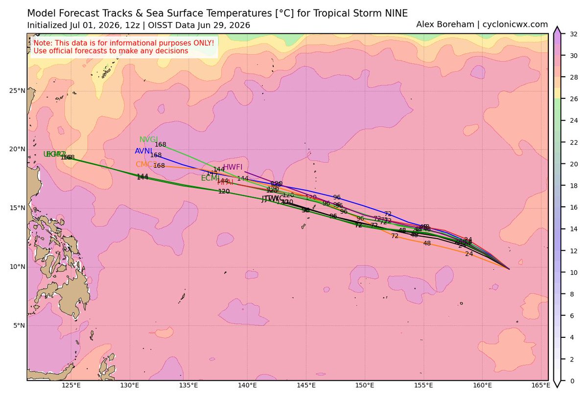
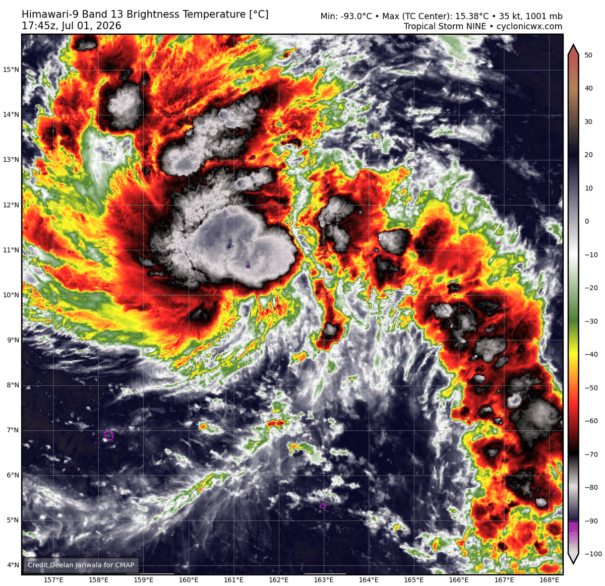
Tropical Storm #09W forecast to quickly intensify throughout the forecast period as it threatens the Northern #Mariana Islands and #Guam. Quickly developing right now and may become a very powerful typhoon within a few days.
Update video to come later today on my YouTube Page!
While currently a bit disorganized, evident LL-ML rotation is present with some loosely defined mid-level circulations present coupled with increased connective activity. TCG is pretty likely atp and could occur very soon, especially as the next DMIN cycle approaches. #Invest95W
Starting to notice developments out of Invest #95W in the WPAC currently, and future long-range ensemble along with model intensity projections have me quite concerned.
While a bit far out, significant ensemble support for a very intense typhoon (C4-C5 intensity) is evident.
Did not expect to see this on my 2026 bingo card…
Likely a quite potent tornado ongoing in Southwestern Manitoba in Canada this evening. Unusually rare situation here, dangerous storm in progress NW of the community of Shoal Lake. Debris ball present on reflectivity!
#MBstorm
BREAKING: According to USGS, Venezuela was struck by two powerful earthquakes in rapid succession — a magnitude 7.2 quake followed by a magnitude 7.5 just 45 seconds later.
VIA:@BNODesk
Severe thunderstorm warning for Central & South Central Mobile, along with Southwestern Baldwin Counties until 5:00 PM CDT.
Damaging wind gusts up to 60mph are the primary concern.
#alwx
Wednesday Afternoon Forecast for June 24th, 2026
Also up on my Facebook, Instagram and TikTok Pages!
FB/TikTok: @patrickfitzwx
Instagram: @patrickfitz_wx
https://t.co/MCsPafr823
6.24.26 | 4:10 PM CT
#alwx#mswx#flwx#weatherforecast#weatherupdate
Severe Thunderstorm Warning for Central Mobile and West Central Baldwin Counties until 4:45 PM CDT. This includes areas near and North of Downtown Mobile, North of the University. Main concern is 60mph damaging wind gusts.
#alwx
Tuesday Evening Forecast Video for June 23rd, 2026
Also up on my Facebook, Instagram and TikTok Pages!
FB/TikTok: @patrickfitzwx
Instagram: @patrickfitz_wx
https://t.co/JdOYWJbsc3
6.23.26 | 5:56 PM CT
#alwx#mswx#flwx#weatherforecast#weatherupdate
Monday Evening Forecast Video for June 22nd, 2026
Also up on my Facebook, Instagram and TikTok Pages!
FB/TikTok: @patrickfitzwx
Instagram: @patrickfitz_wx
https://t.co/tMamsu6j2p
6.22.26 | 6:01 PM CT
#alwx#mswx#flwx#weatherforecast#weatherupdate
2:41 PM CDT:
National Weather Service in Norman, OK along with the SPC confirmed that last night’s destructive MCS that trekked across Oklahoma has been classified as a Derecho. Highest gust observed was 102mph at Hinton, Oklahoma!
#okwx
6.22.26
5:31 PM CT:
Thanks in part to an MCV (mesoscale convective vortex) propagating across the MS/OH River Valleys this afternoon, enhanced low-level lift + convergence and destabilization ahead has fostered several tornadic supercells to develop across Illinois.
#ilwx
5:20 PM CT:
Quite the intense, very dangerous situation ongoing SE of the community of Dix, Illinois this afternoon in Jefferson County. Radar cross sectional debris analysis + VROT readings suggest this tornado likely is an intense tornado ongoing.
#ilwx