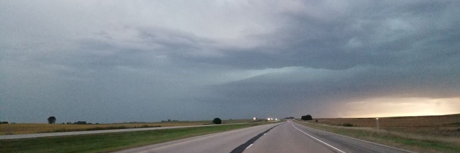
We are targeting a SIGNIFICANT #TORNADO THREAT this late afternoon and evening along a warm front zone along the Iowa/Minnesota Border!
Supercells are forecast to erupt along the warm front from South Dakota to Wisconsin around 4 pm. Forecast models suggest a surface low will migrate along the warm front late afternoon and evening, which should enhance the low-level wind shear ahead of it.
ALSO, the threat of supercells and tornadoes is increasing for Oklahoma into Northwest Texas, including the OKC Metro around rush hour.
Stay tuned to severe weather watches and warnings today from Texas to Wisconsin!
It may be the first day of spring, but this looks a lot more like summer!
This map shows a ridge expanding across the US, allowing temperatures 30-40° above average to surge into Minnesota this weekend.
👉 70s now look likely 👉 Even a few 80s in SW Minnesota
One contributing factor: Dry conditions + limited snowpack out west = more efficient warming
The bigger question: is this a one time thing, or a preview of what’s to come this summer? 🤔👇 #mnwx
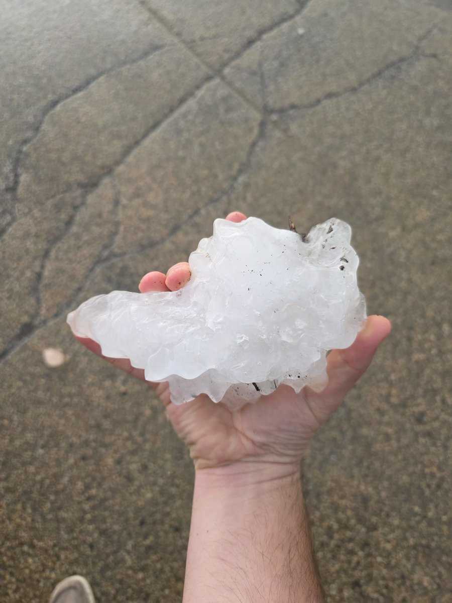
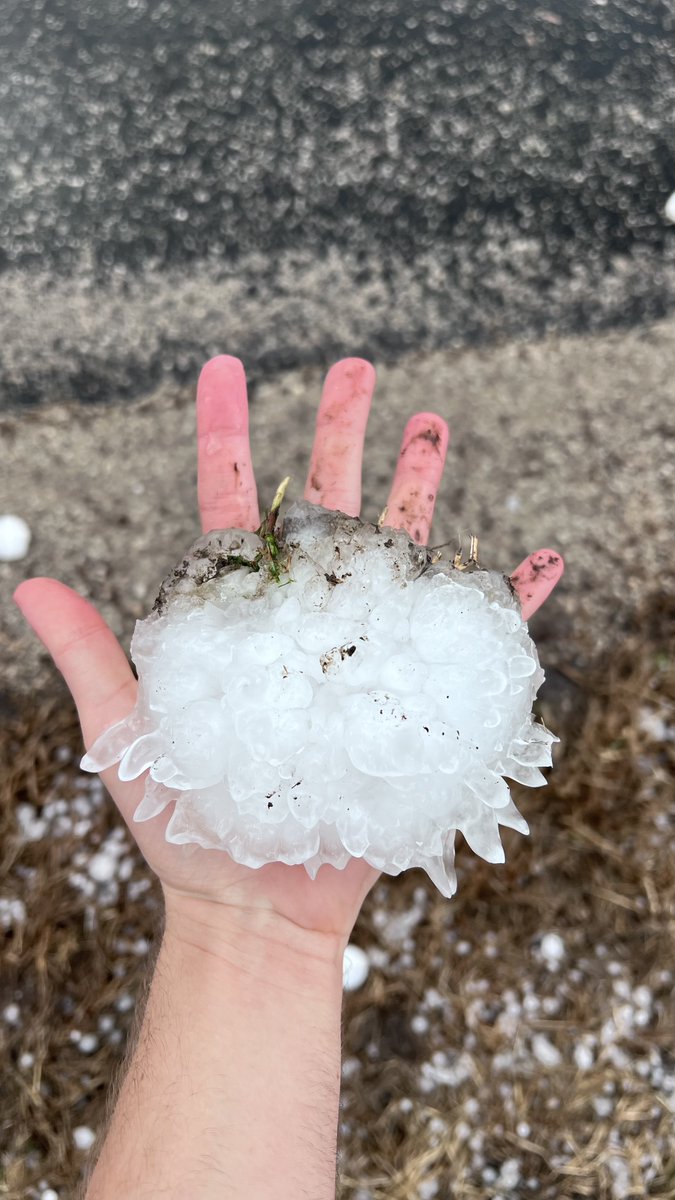
GOES-East 1-mins satellite imagery of storm that produced tornadoes and very large hail across northern Illinois/Indiana on March 10.
More imagery and discussion from this event: https://t.co/yEelYEbQjZ
Here is our event summary webpage for the March 10-11 Severe Weather and Tornadoes: https://t.co/6JbzRbxVGL. NWS meteorologists are reviewing pictures and videos of damage in Wells and Jay counties with local emergency management. Details will be released later this afternoon.
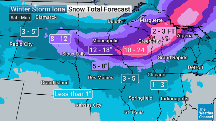
2nd Winter coming in strong across the Upper Midwest. That’s 2-3 FEET of snow from Wisconsin to Michigan. Rochester, The Twin Cities, Madison, Milwaukee, Green Bay, Traverse City…YOU READY?! @weatherchannel
LIVE EMERGENCY UPDATE on strong+ tornado threat today Oklahoma to Wisconsin! We also recap the destructive, long-track #tornado last night across northern Oklahoma from Fairview to east of Wakita, Oklahoma. Sadly, two people lost their lives last night from that tornado as they were struck on the road.
We intercepted a cone tornado west of Quail, Texas in the night.
Today we have another threat of a strong tornado over a much larger target area from eastern Oklahoma/Kansas and Missouri up to southern Wisconsin
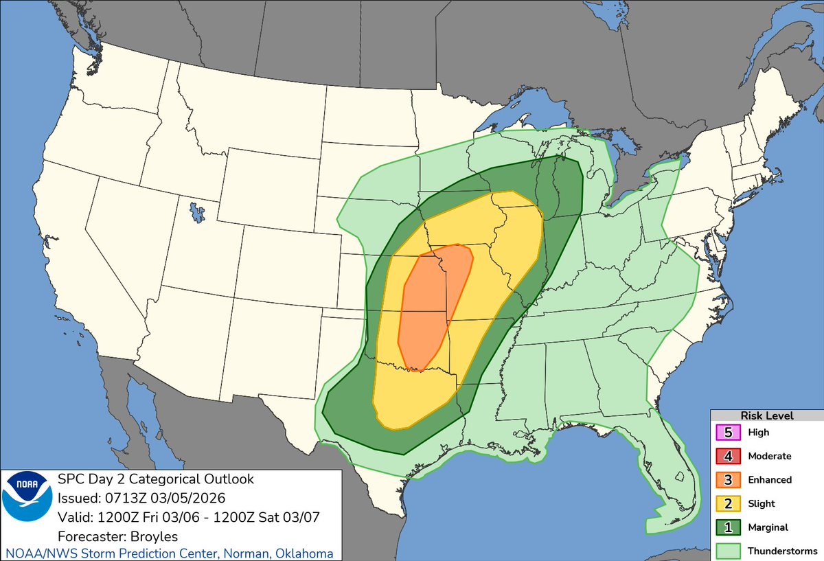
1:15am CST #SPC Day2 Outlook Enhanced Risk: across parts of the southern and central Plains into the lower to mid Missouri Valley https://t.co/Y1WiOd8m1i
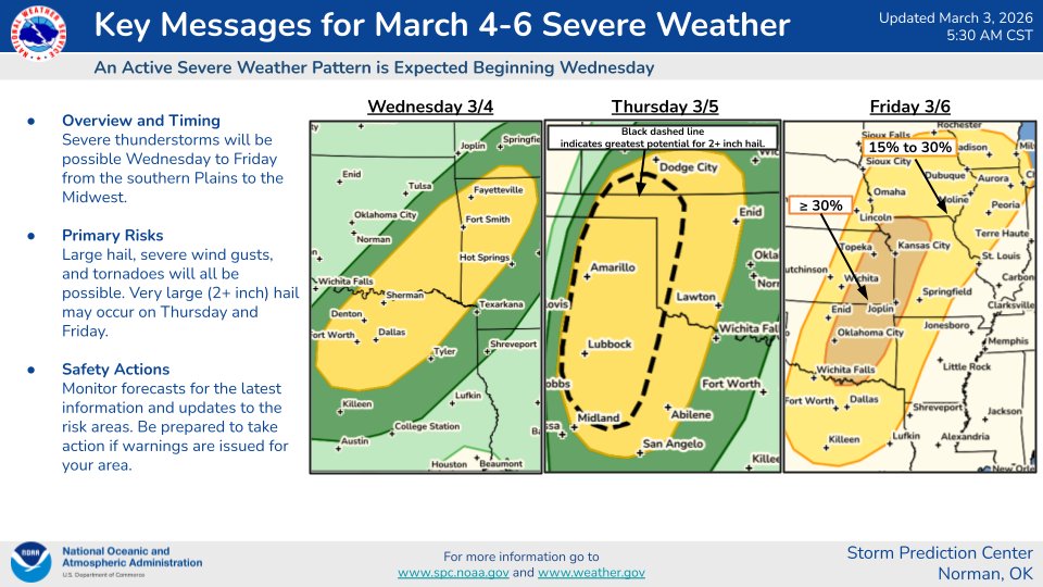
An active severe weather pattern is expected later this week. All severe weather hazards, including large hail, severe wind gusts, and tornadoes, are possible. Very large (2+ inch) hail may occur on Thursday and Friday.
FRIDAY, March 6, 2026 could feature the season's first widespread severe weather threat along I-35 in classic "Tornado Alley."
This includes Dallas-Ft. Worth, Oklahoma City, Kansas City, Waco, Wichita, Tulsa, St. Joseph, Mo. and all the way north into southern Iowa.
The main hazards are large hail up to hen egg size and damaging winds, but there's a decent chance of some tornadoes too. We'll be working to learn more in the days ahead.
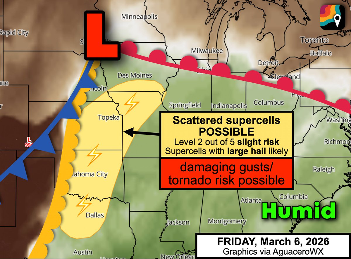
Low pressure near Sioux Falls, S.D. will tug warm, humid air northwards, setting the stage for storms as a cold front approaches from the west. The clash between dry and humid air masses will cause scattered thunderstorms, including a few supercells, to crop up by 3 or 4 p.m.
With frigid air aloft spilling south in a jet stream dip, large hail will be probable with the strongest storms. Changing winds with height could also help a few storms to produce tornadoes.
If you have Friday evening/night plans, have a way to stay abreast of changing weather conditions. With the low-level jet stream ramping up around dark, we believe any severe weather potential could continue into the night.