21 de octubre. El NHC está monitoreando 2 sistemas sobre el Atlántico central y noroeste. El más occidental (Invest #AL93) tiene un 50% de probabilidad de convertirse en una tormenta subtropical y con bajas probabilidades para el sistema al E-SE de Bermudas.
Oct 21 Wed afternoon: NHC is monitoring 2 systems over the central and NW Atlantic Ocean. The westernmost one (Invest #AL93) has a 50% chance to become a subtropical storm, with low chances for the system well E-SE of Bermuda. More: https://t.co/GrztW6nozt
Durante la semana del 4 al 10 de octubre, se mantuvieron las anomalías cálidas de Temperatura Superficial del Mar (#TSM) en el Pacífico Ecuatorial, alcanzando valores cercanos a 6 °C, con mayor intensidad frente a las costas de Ecuador y Perú.
The first hurricane of the 2026 Atlantic hurricane season made landfall in the U.S. late last week.
Watch this satellite view covering the full journey of Hurricane Isaias from its formation in the Gulf to its dissipation over the Eastern U.S.
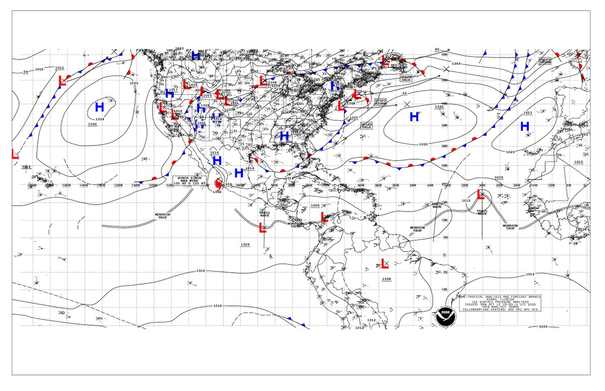
Un par de ondas tropicales continúa moviéndose hacia el oeste a través del Atlántico. Estas ondas están produciendo actualmente convección desorganizada.
La onda que se encuentra a lo largo de 30W tiene una baja probabilidad de desarrollo ciclónico en los próximos 7 días.
A pair of tropical waves continues moving westward across the Atlantic. These waves are currently producing disorganized convection.
The wave currently along 30W has a low chance of tropical cyclone development within 7 days.
Please visit https://t.co/flL526VbS6 for more info.
Si su teclado no cuenta con letra «ñ», anote esta combinación de teclas para no quedarse sin «cariño», «compañía» o «sueños»:
«Alt + 164» (minúscula) → ñ
«Alt + 165» (mayúscula) → Ñ
Huracán Isaias: Las condiciones se deterioran rápidamente en las zonas de marejada ciclónica y alerta de huracán. Se recomienda a los residentes buscar refugio seguro.
Hurricane #Isaias Advisory 13 (4 PM CDT, Fri Oct 9): Conditions Deteriorating Quickly Within the Storm Surge and Hurricane Warning Areas. Residents Should Be Seeking Safe Shelter. https://t.co/GrztW6mQJV
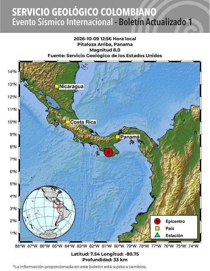
#SismosColombiaSGC Evento Sísmico Internacional - Boletín Actualizado 1, 2026-10-09, 12:56 hora local. Magnitud 8.0. Profundidad 33 km, Pitaloza Arriba, Panama #NoticiaEnDesarrollo#Temblor#Sismo Más información: https://t.co/63pt8nVsSe
ACTUALIZACIÓN
ISAIAS YA ES HURACÁN MAYOR
🌀
Isaias alcanza la Categoría 3, en aproximación a las costas de Florida y Alabama EEUU 🇺🇸
- Vientos 195 km/h
390 km al S de Pensacola, Florida y
275 km al SSE de la Boca del Río, Mississippi
Se mueve al NNE 24 km/h
Aviso de Marejada Ciclónica está en efecto de la Boca del Río Mississippi al Río Suwannee, FL
#Hurricane #Isaias
Nolo crossed the International Date Line and entered the Western Pacific over the weekend, being reclassified from a hurricane to Typhoon Nolo.
Nolo is the equivalent of a Category 3 storm, and is forecast to remain over the open ocean as it continues westward.
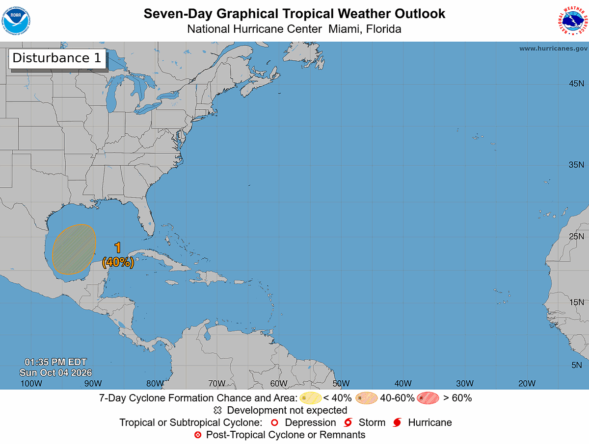
Es probable que se forme un área de baja presión alrededor de la mitad de la semana sobre el suroeste del Golfo de México. Y una depresión tropical podría formarse a finales de esa semana mientras el sistema se desplaza hacia el norte.
2 pm EDT Oct 4 --- An area of low pressure is likely to form around the middle of the week over the southwestern Gulf of America. A tropical depression could form late this week while the system drifts northward. Visit https://t.co/GrztW6nozt for updates.
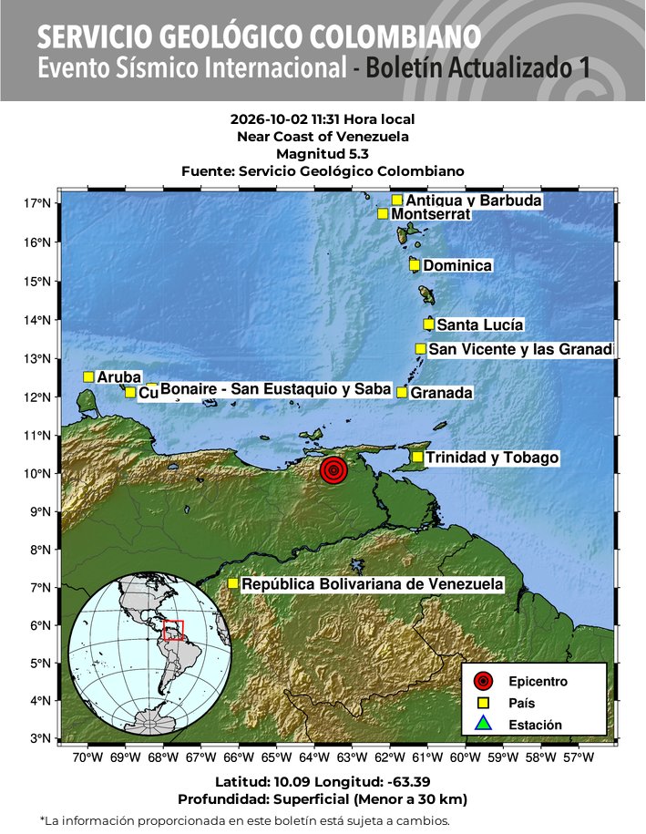
#SismosColombiaSGC Evento Sísmico Internacional - Boletín Actualizado 1, 2026-10-02, 11:31 hora local. Magnitud 5.3. Profundidad superficial, Near Coast of Venezuela #NoticiaEnDesarrollo#Temblor#Sismo Más información: https://t.co/63pt8nVsSe
10/2 - Un sistema de baja presión en niveles altos sobre el SE de México y una abundante humedad están originando chubascos y tormentas eléctricas en gran parte del NW del Caribe y el E del Golfo. Los navegantes pueden esperar aguaceros intensos, vientos fuertes y mar agitado.
10/2 - An upper-level low over SE Mexico and abundant moisture are supporting showers and thunderstorms across much of the NW Caribbean and E Gulf. Mariners can expect heavy downpours, gusty winds, and sudden higher seas.
More: https://t.co/Wk7xxBlxYC #GOESEast#marinewx
¡Se esperan vientos del E moderados a fuertes al N de Venezuela y Colombia durante las tardes de este fin de semana/principios de la próxima semana, también monitoreando un frente frío para principios de la próxima semana!
The latest Tropical Atlantic Marine Weather Briefing can be viewed here: https://t.co/vh4fOebRR4
Fresh to strong E winds can be expected offshore Venezuela and Colombia during the evenings this weekend/early next week, also monitoring a cold front for early next week! #marinewx
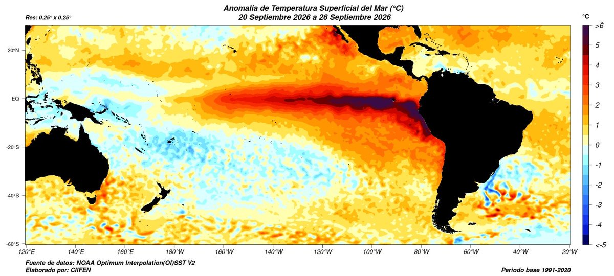
Durante la semana del 20 al 26 de septiembre, se mantuvieron las anomalías cálidas de Temperatura Superficial del Mar (#TSM) en el Pacífico Ecuatorial, con mayor intensidad en el Pacífico Central y Oriental, con anomalías entre 2.5°C hasta 6°C por sobre lo normal.
Tormenta Tropical #Hanna pronosticada para ser una tormenta tropical de corta duración mientras se mueve hacia el este a través del Atlántico Subtropical Central. https://t.co/6TqAlRpB3z
Tropical Storm #Hanna Advisory 2 (5 PM AST, Mon Sep 28): Hanna Forecast to Be a Short Lived Tropical Storm as it Moves Eastward Across the Central Subtropical Atlantic. https://t.co/GrztW6mQJV