@BDAOfficialGok
The Hon'ble Supreme Court has unequivocally held that "safe and demarcated footpaths are a Fundamental Right under Articles 19(1)(d) and 21, and must take precedence over vehicle movement".
#NPKL deserves proper #footpaths. We hope BDA will now provide continuous pedestrian infrastructure along 30 ft to 100 ft roads across the layout and uphold citizens' #FundamentalRight to #SafeWalkingSpaces.
@Captain_Mani72 Unfortunately, whenever the issue of footpaths was raised, it was often viewed as a "new demand", a "legacy issue", a "reduction in road width", even it was said expense to be borne by allottees, or even met with questions about what site owners were doing in 2016.
The Supreme Court's verdict makes it clear that safe pedestrian infrastructure is neither " a luxury nor a new demand" —it is an "integral part of urban planning and a constitutional necessity". "Past planning and implementation flaws must be rectified on priority".
Citizens deserve safe, accessible, and continuous walking spaces.
@CMofKarnataka@DKShivakumar@mlanaharis@TVMohandasPai
#NPKL #BDA #Walkability #PedestrianRights
@naveenmzs@nkaggere@ChristinMP_@ShreyasJurno@tulasikVV@sampathtke01@BoskyKhanna@Lolita_TNIE
@DKShivakumar@mlanaharis@ShobhaBJP@nimmasuresh@STSomashekarMLA
Dear @BDAOfficialGok,
1) In social media interactions and previous NPKL review meetings, BDA acknowledged the need for footpath formation across 30 ft to 100 ft roads. Commissioner @Captain_Mani72 sir had directed the Engineering Team to prepare the necessary plans and cost estimates and place the proposal before the BDA Board.
A recent BDA Board meeting has been held. Could @BDAOfficialGok clarify the decision taken regarding footpath development in #NadaprabhuKempegowdaLayout ?
Has the Board approved the proposal? Have the design, estimates, implementation plan, and funding mechanism been finalized?
Site owners would appreciate a clear update, as safe and accessible footpaths are an essential component of a well-planned layout.
2) In addition, covering open culverts and providing safe pedestrian crossings is equally important for resident safety and walkability across the layout.
#NPKL #NadaprabhuKempegowdaLayout #BDA #Footpath #SafePedestrian #BangaloreDevelopmentAuthority
#Bangalore
Look at the cycling infrastructure in Hyderabad!
The dedicated solar-roof cycling track is an incredible example of sustainable, forward-thinking urban planning. Segregated, safe, and smart. This is exactly the kind of modern design our growing layouts and major arterial roads need!
@DKShivakumar@ShobhaBJP@nimmasuresh@STSomashekarMLA@Captain_Mani72@mlanaharis
@BDAOfficialGok
Compound walls were constructed based on 9 years earlier BDA marking stones and subsequent site verification carried out before construction. However, recent yellow demarcation markings now appear to indicate a different boundary alignment???
If the latest markings are correct, why do they differ from the earlier demarcation on which site owners seen from 9 years, relied for compound wall and construction? Rework utility connections?
Such inconsistencies in site demarcation create confusion, require rework of household connections, and potentially lead to future disputes for allottees.
@DKShivakumar@mlanaharis@ShobhaBJP@nimmasuresh@STSomashekarMLA@naveenmzs@nkaggere@ChristinMP_@BoskyKhanna@Lolita_TNIE@tulasikVV@sampathtke01
@BDAOfficialGok How can survey markings done recently differ from the survey, marking stones, utility chambers, and utility infrastructure established nearly 9 years ago?
Site demarcation markings now appear to overlap utility chambers and cut through areas where infrastructure was already executed based on earlier markings.
If the latest demarcation is correct, how were utilities and chambers laid earlier? If the earlier marking was correct, why are current markings differing?
@DKShivakumar@ShobhaBJP@nimmasuresh@STSomashekarMLA
Thank you for the detailed clarification from BDA Helpline.
It is encouraging to see acknowledgement of legacy issues in NPKL and the continued commitment towards completing pending infrastructure and rectification works. However, site owners now look forward to seeing these issues resolved meaningfully on ground.
At the same time, the concerns being raised by site owners are based on actual ground observations over the last 9 years, repeated review meetings, official statements, and implementation changes noticed by residents themselves.
1) If the current activities are not officially termed as “survey,” then clarity may kindly be provided on what exactly the ongoing demarcation, numbering corrections, GPS-tagging references, cleaning, and yellow marking activities across the layout are. Even engineers on ground are acknowledging marking discrepancies in certain areas. When visible numbering/marking activities are happening across the layout and discrepancies are observed, later stating “no survey activity” doesn't make any sense.
2) Regarding footpaths, site owners welcome that the matter is under consideration. However, this concern was officially raised years ago and repeatedly discussed in review meetings where it was acknowledged that footpaths were not planned in any roads. Hence, residents will naturally continue to follow up until a concrete Board decision and implementation roadmap emerge.
3) On deadlines, site owners understand external constraints like bitumen shortage. However, concerns arise because earlier status presentations and public communications often projected works as completed or on track, while later in very recent review meetings reflected different ground realities.
4) Public participation should not be viewed negatively. Many active NPKL site owners have invested life savings, waited nearly a decade, and closely tracked the project throughout. Their feedback comes from lived experience and continuous observation on ground, not from assumptions.
5) Transparency, open inspections, comparative scheme-plan discussions, and timely clarification of implementation issues will only strengthen public confidence further.
Ultimately, site owners want the outcome — a genuinely well-planned, safe, transparent, and fully developed NPKL for future residents.
@DKShivakumar@mlanaharis@nimmasuresh@STSomashekarMLA
In a review meeting nearly 5 months ago, @Captain_Mani72, a clear process was promised for site cleaning, culvert clearing, surveying, and installing stone markings/numbering,signboards to @BDAOfficialGok
- The plan was to complete one pilot sector, conduct a joint inspection with site owners, and scale it across all blocks only after everyone’s nod. Unfortunately, this promised framework was completely bypassed.
Instead, site and culvert cleaning, surveys, and yellow-paint numbering have commenced in a few blocks without proper plan and flpw.
This haphazard execution has led to a mismatch between the original numbers from 9 years ago , the new markings and GPS tagging.
We need immediate clarity on two critical fronts:
1) The mismatch between the original site numbering from 9 years ago and the recent road yellow paint numbering.
2) The discrepancy between the survey boundaries established 9 years ago and the current yellow paint markings.
While the engineers acknowledges these errors on a one-off basis when approached by worried site owners, fixing individual complaints reactively won't solve a systemic failure.
Executing surveys and numbering in this flawed manner is a recipe for permanent litigation and chaos for thousands of allottees. We need the promised systematic approach, not rushed, erroneous paint jobs. @BDAOfficialGok@mlanaharis
In attached video culvert, sites not cleaned, yellow marking done by missing site numbers.
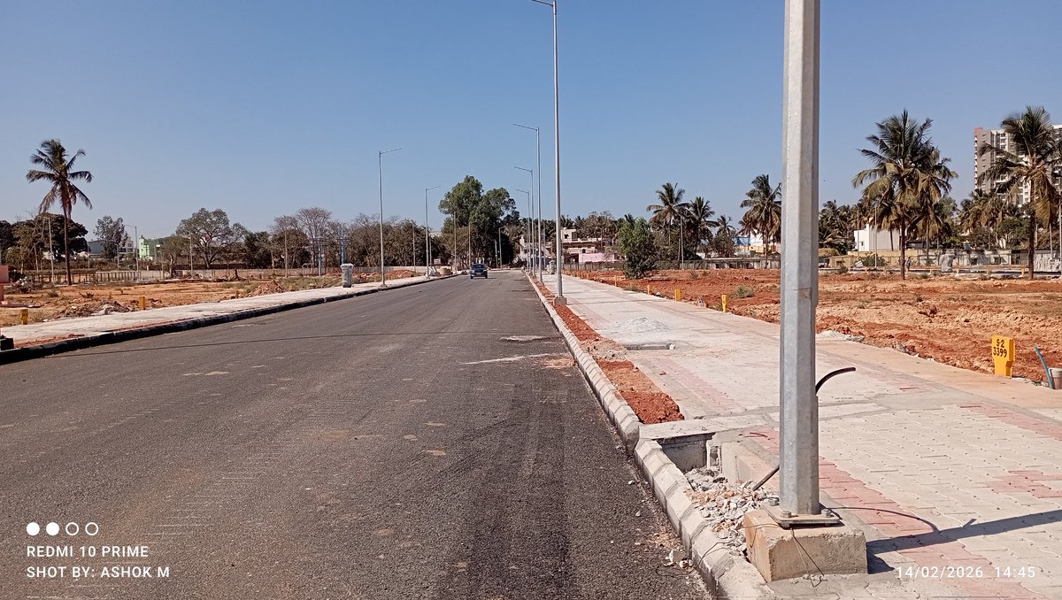
Haphazard planning by @BDAOfficialGok Town Planner and rectification awaited! 30ft to 100ft roads in #NadaprabhuKempegowdaLayout were designed with ZERO footpaths. What have the TPM and Engineering teams done over the past 9 years on this project to let such major flaws go unfixed?!
Instead of accountability, site owners face endless questions for highlighting flaw :
1) Called it a "new design"
2) Blamed the original scheme plan
3) New ask
4) Asked why site owners didn't point it out in 2016
5) Retrofitting them now will narrow the existing road width
6) Let's see in future
7) Shocking twist: Site owners are now being asked to pay for this design flaw's implementation!
While BDA finally agrees footpaths are needed, the proposal has been trapped with the engineering team for months—even after instructions from @Captain_Mani72—and still awaits a board nod.
Will this agenda finally be cleared in the upcoming board meeting? Why should citizens pay for your planning failures? @mlanaharis@Captain_Mani72
Pic 1,2: NPKL
Pic 3,4: DrSKLayout
@ShobhaBJP@nimmasuresh@STSomashekarMLA@shalinirajnish@naveenmzs@Lolita_TNIE@BoskyKhanna@nkaggere@ChristinMP_@ShreyasJurno@ashwinmahesh@KiranParashar21@KiranTNIE1@TVMohandasPai@kiranshaw @
@Captain_Mani72@BDAOfficialGok
Inside the same site, GPS apps are showing site number 2216 while BDA’s recent yellow ground marking shows 2185, number written 9 years ago was different.
Which one is correct?
After 9 years, if GPS tagging, Google mapping, old allotment markings, and recent survey markings themselves are not matching, how are site owners expected to proceed confidently with construction, registrations, utility connections, or purchases?
If new GPS mapping is accurate, then:
• Are old markings wrong?
• Will documents require rectification?
@DKShivakumar@mlanaharis@ShobhaBJP@nimmasuresh@STSomashekarMLA
@DKShivakumar@ShobhaBJP@nimmasuresh@STSomashekarMLA@mlanaharis@Captain_Mani72@BDAOfficialGok Is the site marking and dimension demarcation in #NPKL truly correct and accurate?
1) Site owners are observed the GPS-tagged/Google Map numbers and the site numbers written during allotment appear to be mismatching.
In the attached picture 1 & 2, the site number written nearly 9 years ago, the survey number now painted on ground in yellow, and the current GPS mapping do not appear to match each other.
2) Current site demarcation is extending beyond the earlier marking stones previously placed on ground. Due to this, even household utility connections terminated based on earlier markings may now require rework if the new GPS mapping is considered accurate.
As seen in the attached photo, a few recently constructed compound walls have extended beyond the previous marking stones. When enquired, owners stated that construction was done after recent survey confirmation. If the latest marking is considered correct, then existing household utility connection points may face alignment and access issues.
3) Some real-estate agents/site sellers are also displaying or writing site numbers that do not match the approved drawing series or official numbering, which may create major confusion and future disputes for buyers and site owners.
If the new GPS mapping is considered accurate and site positions are shifting in a majority of areas, then corresponding rectification in documents and proper public clarification may also become necessary.
Clear, transparent, and accurate site demarcation is essential to avoid disputes, legal confusion, and repeated rework for residents.
@ashwinmahesh@naveenmzs@nkaggere@ShreyasJurno@Lolita_TNIE@ChristinMP_@tulasikVV@Punya89142601@Maheshbr4U@ShyamSPrasad@sampathtke01@bengalurupost1
@DKShivakumar@mlanaharis@ShobhaBJP@nimmasuresh@STSomashekarMLA@Captain_Mani72@BDAOfficialGok
SWD and HT-line buffer zones are being termed as parks across NPKL. Claims are made that wider recreational parks are available in every block, but on both the approved maps and actual ground reality, such usable open spaces are not visible in majority blocks. In NPKL, even basic playground infrastructure is still not properly available.
Whereas in Dr. Shivaram Karanth Layout which is well planned like jayanagar — which many feel was better planned and executed under court monitoring — DPR/tender publication for stadium development has already been initiated even before large-scale site distribution. 😌
Supreme Court / Justice Chandrashekar Committee & High Court monitored layout progress v/s BDA monitored almost 9-year-old NPKL still under work-in-progress project.
While Bangalore Development Authority states Nadaprabhu Kempegowda Layout work is on “fast track” and in “final stage,” many site owners see a major difference when comparing NPKL with Dr. Shivaram Karanth Layout infrastructure quality and execution progress.
The concern is not just percentage completion, but actual finishing quality and ground-level execution. In several areas of NPKL, final finishing itself appears incomplete — including road edge finishing, culvert cleaning, pathway continuity, site grading, utility finishing, and overall layout presentation — whereas DrSK Layout appears more refined and systematically executed.
@DKShivakumar@mlanaharis@nimmasuresh@STSomashekarMLA@Captain_Mani72@BDAOfficialGok
Video 1: NPKL sunday video from one of block.
Video 2: DrSKLayout video captured almost 4-5 months ago.
@DKShivakumar@ShobhaBJP@nimmasuresh@STSomashekarMLA@mlanaharis@Captain_Mani72@hrsrajanna@CNASHOKA1@BDAOfficialGok
Under the Karnataka Town and Country Planning Act, 1961 (Sec. 17) and applicable BDA/Planning Regulations:
* Layout approvals mandate reservation of land for parks, playgrounds, and open spaces (generally ~10% of total area)
* Such land must be usable, accessible, and meant for public recreation
* Areas reserved for infrastructure constraints cannot be counted as recreational parks
BDA including non-usable areas such as:
* Storm Water Drain (SWD) buffers
* High Tension (HT) line corridors
…within “park” calculations to meet mandated ratios.
This is a clear deviation from planning intent, as:
* SWD buffers are regulated no-build / safety zones, not recreational spaces
* HT line buffers are hazard-prone and unsuitable for children or public use
* Counting such areas as parks defeats the purpose of livable urban design
1. What is the actual percentage of parks and playgrounds excluding SWD buffers, HT line corridors, and other restricted zones?
2. In review meetings, it is stated that "each block has large parks”. Kindly publish: Park-wise area (big to small)
* Survey numbers / sector details
* Classification (park vs. playground vs. open space)
* Clearly excluding SWD / HT buffer areas
* Parks must be functional recreational spaces, not residual or constrained land
* Misclassification may violate:
* Karnataka Town and Country Planning Act, 1961 (Sec. 17 – layout approval conditions)
* Approved Comprehensive Development Plan (CDP) / Master Plan norms
* Public amenities must align with principles of planned development and natural justice
Ground reality :-
* public are forced to travel long distances to access even buffer zones as parks
* Children are left with unsafe alternatives under HT lines / near drains
* This contradicts the very purpose of a planned layout