Only a few patches of snow from last weekend's snowstorm are left on the summit after the warm temperatures we've had over the past few days. Seen here is one of the last on the summit cone itself near Goofer Point around sunset yesterday. (1/2)
Starting this month, more than 900 deep-sea ocean sensors will be pulled out of the Pacific and Atlantic oceans off the coast of Washington, Oregon, Alaska, North Carolina and Greenland. https://t.co/jmm86WQNcY
📅⛈️ On this day 6 years ago, a destructive derecho swept across central & southeast PA, & southern NJ. 60-75 mph wind gusts occurred in a swath upward of 50-60 miles wide. Notable measured gusts include 83 mph at Reading Regional Airport, PA & 93 mph at Beach Haven, NJ. (1/3)
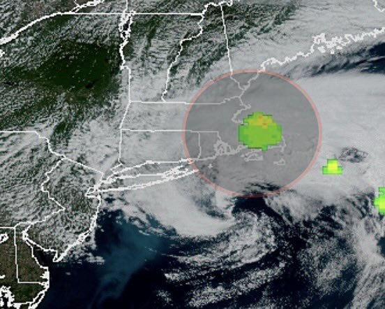
This is something I have never seen before on satellite.
Clouds perfectly outlining roads.
Just incredibly neat imagery of Houston, Texas this morning.
Massive shoutout to @Emokwx who discovered it.
👀🔙June 2 in #PAwx History
🌪️1998: Tornado outbreak #2 following May 31st
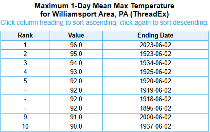
🌡️2023: Heat Wave @flyIPT broke 100yr-old daily record max temperature record hitting 96°F
The pride flag was designed in 1978 by Gilbert Baker, at the behest of gay activist and city official Harvey Milk, who thought that the Gay Pride movement needed a logo.
The original-purpose flag was constructed by Baker with hand-dyed fabric and consisted of eight stripes.
🏳️🌈 Happy Pride Month!
✨ Many colours, one planet. With #EUSpace and #CopernicusEU, diversity is visible from above. We've brought together twelve colourful views of Earth observed from space.
🌈 Let's celebrate love, diversity and inclusion together!
May 31st: One of the most infamous & deadliest days in PA weather history:
•1889 Johnstown Flood: Triggered by torrential, unrelenting rainfall, this deluge left 2,209 people dead
@JohnstownFldNPS
•1985 Tornado Outbreak: Deadliest outbreak resulting in 65 deaths & PA's only F5
NEW: NASA has pinpointed where Saturday's meteorite likely landed — and says someone may actually be able to recover it.
Using weather radar data, NASA traced debris from the meteor that boomed across New England to a spot in Cape Cod Bay near:
📍41.87754 N, -70.35239 W
Jefferson and Washington from the OMNI Mt. Washington Resort Saturday afternoon with telephoto close-ups of the Observatory trying to break out of the clouds and the Cog Railway; if you look closely you can see one of the trains.
--
May 30, 2026
Carroll, New Hampshire
The snow-capped Presidential Range seen from US Route 2 (at Six Gun City), followed by Jefferson Meadows along NH Route 115.
--
May 30, 2026
Jefferson, New Hampshire
NEW ENGLAND METEOR UPDATE: the space rock had a diameter of about 3 ft before it broke up. According to NASA, it was traveling at 75,000mph & broke up approximately 40 miles above Earth. The energy released equivalent to 300 tons of TNT. The boom/shaking was heard in RI, MA & CT
We want to hear from you! The NWS is planning to modernize its COOP network by harnessing new technology, optimizing observation sites and leveraging high-quality commercial data. Weigh in on our recently-published Request for Comment! https://t.co/kxLbvOEjcb