The real test for physical AI isn't a task in a pristine lab. It's the chaos of a living room.
A humanoid plumping a soft pillow looks brainless to us. To a neural network, it's a nightmare. Soft objects deform. Fabric shifts, lighting changes, friction changes with every touch. You can't fully capture that in simulation, and you can't scrape it from the web.
That's the gap between digital and physical AI. One lives in pixels, tokens, and clean logic. The other lives in force feedback, dynamics, and messy real-world environments.
A 100-billion-parameter model means nothing if the robot tears the fabric the second the light shifts. The bottleneck isn't compute anymore. It's high-fidelity physical interaction, grounded in real, continuous, tactile feedback.
The teams building real general-purpose robots aren't just training models. They're collecting the millions of unglamorous physical edge cases standard datasets ignore.
Until your robot can fold a blanket and fluff a pillow in a real room without breaking a sweat, it's just a demo.
Collecting that real-world interaction data is the whole job at Robotic Data. If it's the gap in your program, talk to an expert → https://t.co/VzqMHgItYx
#PhysicalAI #EmbodiedAI #Robotics #TrainingData #RoboticData
The best way to teach a robot a task is to show it the task from the eyes of the person doing it.
That is what egocentric capture is. A wearable camera records a task from the first-person point of view, the same rough vantage a robot has when it tries to repeat it.
Human egocentric video data is some of the most useful data for teaching manipulation and everyday tasks, because it captures intent and motion together: what the hand does, what the eyes track, how the task actually unfolds.
On its own, video is not enough. Real capability comes from multimodal training data, egocentric and third-person video synchronized with 3D capture, audio, and motion, so the system learns the full picture, not one channel of it.
At Robotic Data, that kind of synchronized, multi-modal sensor data collection is what our Human Data programs are built to produce, at the scale a training run needs.
If egocentric or multi-modal human data is on your roadmap, let’s have a conversation.
#egocentricvideo #EmbodiedAI #MultimodalAI #robotics #roboticdata
What can a spatially intelligent digital twin do?
Spot risks like vegetation encroachment before they cause problems—transforming energy ops from reactive to predictive.
This LiDAR view isn’t just a map—it’s a smarter, resilient future.
#DigitalTwin#LiDAR#PredictiveMaintenance
What are you really seeing here?
A #LiDAR-derived point cloud of a street in the #EastBay—where every color-coded object reveals poles, wires, and vegetation, all spatially classified.
This is how utilities see risk before it happens.
#Voxelmaps#DigitalTwin#UtilityInspection
Scaling autonomous operations demands more than basic maps.
Voxelmaps delivers diverse, high-fidelity data to help machines see, hear, and understand the real world—powering smarter, inclusive AV systems.
Ready to lead the future of autonomy? Let´s talk.
#AutonomousVehicles
Real-world #AI demands real-world data. #Voxelmaps delivers high-fidelity 3D environments—like this street scene—to power autonomous systems, AR/VR, and advanced computer vision at scale.
Discover how comprehensive global data can accelerate your AI.
#ComputerVision#HDMapping
At the recent Accenture International Utilities and Energy Conference, Brian Soliday explored one of the sector’s most pressing shifts: moving beyond static geospatial tools toward dynamic, AI-powered Spatial Digital Twins.
(1/2)
#EnergyTransition#DigitalTwins#AIinEnergy
From palm-lined streets to dense urban corridors, we capture the world in detailed 3D—powering AI to interpret space, sound, & objects like humans do. From AV navigation to smart cities and AR/VR, our global data solutions scale human-centric datasets that digitize the world.
Authenticity in data matters. Our datasets reflect real-world conditions with the detail and dimensionality needed to power next-generation #DigitalT#wins.
From facilities management to city-scale modeling, #Voxelmaps delivers high-precision, multi-sensor data pipelines.
Transform LiDAR & imagery into rich 3D insights with Voxelmaps Insight Platform (VIP). Scalable, AI-powered mapping for AVs, telecom & smart cities—indoor or out, with cm-level precision.
🔗 https://t.co/gDCPRIADQw
Precision in Play: From Batter's Box to Stands (and Beyond).
At Voxelmaps, every measurement tells a story. Whether it’s the distance from home plate to the front-row seats or the arc of a potential home run, our geospatial technology captures it all with high-level accuracy.
Providing a view into the evolution in how we perceive & manage our vital energy infrastructure, to move 'Beyond Mapping’, towards a predictive-based future powered by 4D Spatial Digital Twins. Thanks to all the organizers & attendees we’re heading home full of ideas! 2/2
Wrap up of #IUEC2025: Voxelmaps team had an inspiring few days at this years Accenture International Utilities and Energy Conference where our own CRO Brian Soliday gave a presentation on Beyond Mapping: Dynamic AI-Powered Spatial Digital Twins for the Future Energy Ecosystem 1/2
Today at #IUEC2025: Don’t miss Voxelmaps CRO Brian Soliday at 9–10AM during Innovation Hour!
Topic: Beyond Mapping: AI-Powered Spatial Digital Twins for Energy.
Photo of Julie Sweet, Accenture CEO & Chair, session yesterday.
#Voxelmaps#Utilities#AI#Innovation
Fueling smarter #AISystems with massive, real-world #datasets.
We provide meticulously curated data to ensure your AI models are robust, unbiased, and perform optimally. Our global capabilities help make your B2B solutions world-ready.
Observe the detail: from the unique architecture to each of the numerous cars filling this space, Voxelmaps captures it all.
Our high-fidelity 3D models can distinguish individual assets even in complex scenes like this, providing invaluable data to understand dense environments.
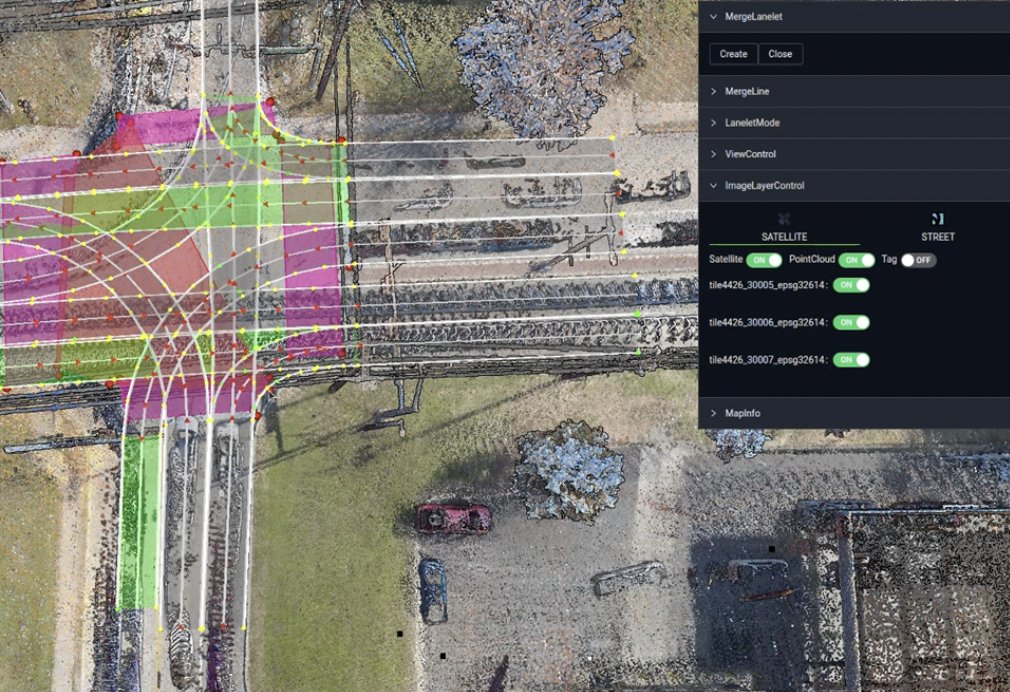
Precision in every voxel, every vector.
Voxelmaps delivers high-definition mapping solutions that form the foundation for advanced driver-assistance systems (ADAS) and autonomous vehicle (AV) navigation.
#Voxelmaps#VectorMap#LaneDetection#ADAS#AutonomousDriving#HDMapping
Data accuracy and operational efficiency are make-or-break factors for autonomous vehicle success.
Learn how Voxelmaps is helping industry leaders reduce risk through their data solutions, enabling businesses to scale smarter https://t.co/u9aDyaIfRh