Please follow Supergeo Technologies on social media‼️
Get the latest information of Supergeo and product news!😁
We’ll also share some interesting GIS news weekly
and provide you with first-hand information about GIS industries in around the world!🌏
#GIS#Supergeo#Taiwan
Congratulations❗️ Supergeo has been listed in 'Global Cloud-Based Mapping Service Market' report for global top GIS-related companies🎉🥇
👇For more info:
https://t.co/1RFeYyiWxT
#AMA#GIS#Taiwan#Supergeo
🎉We're delighted to announce that Win-Win Infosys Limited has become our exclusive reseller in Bangladesh🇧🇩!
For more Supergeo products information👇: https://t.co/zVeYhPAlJ1
Win-Win official website: https://t.co/US9yNn7qPw
#Bangladesh, #Reseller, #Taiwan, #GIS
It is a great honor to announce that the 1968 APP, which launched on the new version of the Freeway Bureau, selected the Supergeo GIS Server core engine and Map API.
For more information, 🔍1968 APP
#1968APP#Android#iOS#highway
This summer, Supergeo was invited to the Technology Seminar organized by the Geospatial Information Agency of Indonesia. However, to improve the versatility of the Indonesian Market, Supergeo provides the Indonesian SuperGIS Desktop, implementing product friendliness.
Supergeo Africa's service covers the entire African market and is a very important strategic partner of Supergeo. It provides a full range of integrated solutions of software and hardware and high-precision survey equipment.
Read more:https://t.co/t8JuT36Doq
NEON Science utilizing multiple GIS-related tools such as satellites and LiDAR to record the data of the storm which stroke Boulder County, the United States in 2013 and the impact of it on the environment.
Check the video below to see how they work :
https://t.co/jS7q9MXa3g
#Esri published a road safety model recently to help improve the prediction and prevention on the issue of road safety. The areas with the highest risk will show on the map after importing variables which might influence the traffic.
To learn more: https://t.co/jqNqziTek4
Here is a website called "Escape". Literally, you can escape from your city by searching for all the flight tickets depart from your home. Such a best platform for who wants to travel abroad without a plan😍
Link:https://t.co/bnG2t5KRmj
This is Dragon Boat Festival Day! The Dragon Boat Festival traditionally falls on the fifth day of the fifth month in the Chinese Lunar Calendar. We will watch dragon boat races and eat Zongzi, which is made of rice with delicious filling inside, to commemorate a legendary poet.
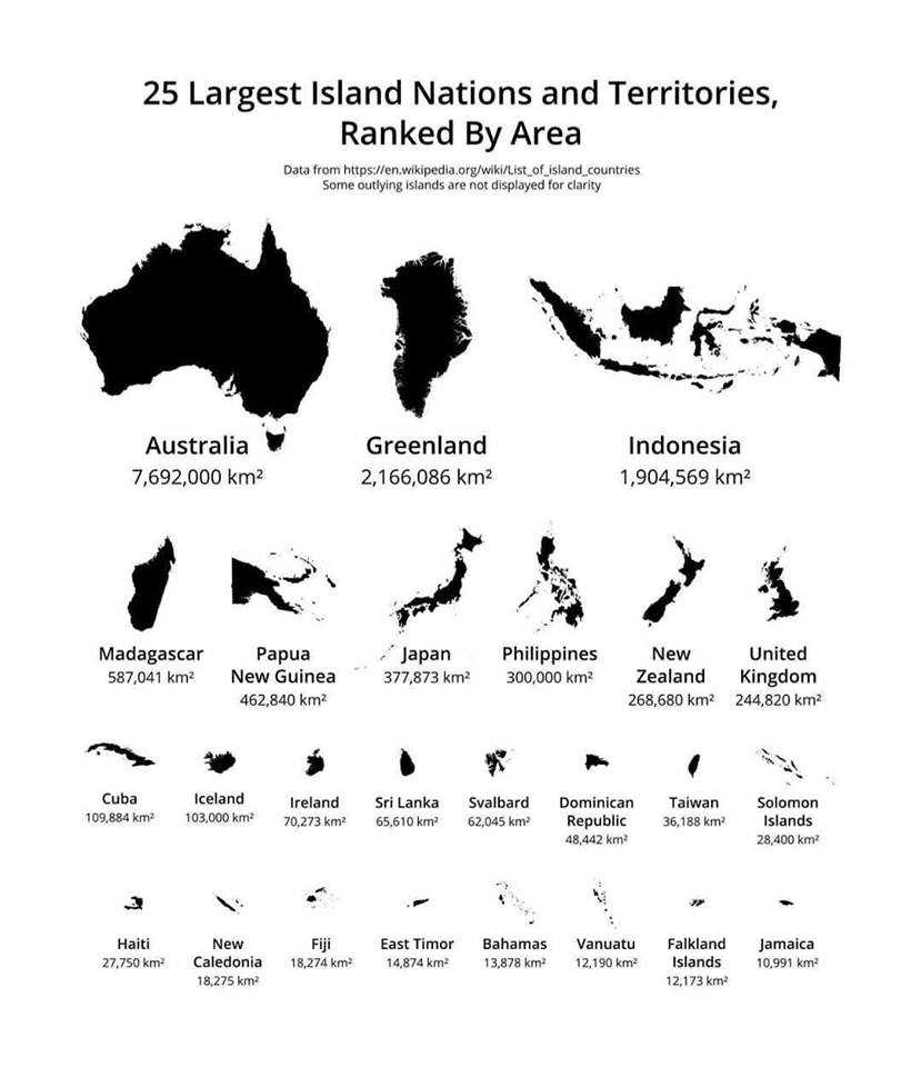
GEOGRAPHY trivia!! The largest islands ranked by size. Try to look for where you from on this photo if you are also an island occupant. Me first, Taiwan is the 16th biggest island in the world!!
Source: https://t.co/IS69Ya8WbN
Here is an easy(or not) game to test how much you know about the national flags around the world! You have to drag every flag to the corresponding country on the interactive map.
Click here to see if you are the king of national flags:https://t.co/1IBtuy8JpR
This is a video of GPS tracking of multiple wolves in six different packs around Voyageurs National Park, Minnesota, which shows how much the wolf packs avoid each other's range.
video: https://t.co/lEn1AyJx3P
Supergeo met with the general manager of Magellan Systems Japan (MSJ) - Mr.Nobuhiro Kishimoto from Japan this month. MSJ is impressed by the rapid development of GIS technology in Taiwan, especially for the application in the field of smart agriculture.
https://t.co/G6v00QopPF
Here's the website that takes you through 750 million years of Earth geologic history. What's more, the information of every geological time has been shown on the site. Click the link below to experience the attracted prehistoric world right now!!
【Earth Geologic History Map🌎】
Here's the website that takes you through 750 million years of Earth geologic history. What's more, the information of every geological time has been shown on the site. Click the link... https://t.co/1I9HOQQVuf
The beta version of SuperSurv 10.2 has been launched. One obvious difference between the two versions is the improvement of UI. In terms of positioning service, QZSS joins as one of the support systems in SuperSurv 10.2 which brings outdoor positioning into a further level.
【2D vs 3D Extrudefeatures】
Here comes a tip about the advantage of 3D map!!
In 2D map, we often utilize "unique values" or "graduated colors" to display information. For example, we can find the distribution of... https://t.co/btkbAp0mYW
Recently, the newest 1968 English version website has been opened to the public! However, only parts of the interface support English operation while most parts of the website such as map and searching system are still Chinese only.
Link : https://t.co/e3SvBE6MtT