Somayajulu Reddy. Expertise in weather forecasting for Kakinada-Pavadanada and the world. 99.99% accuracy. Hype-less. Ban all other Pvt weathermen. Parody.
Wells Fargo in Chennai shut. Employees told to shift either to Bengaluru or Hyderabad. The process begun as early as mid 2025 and Chennai lost a big firm in the BFSI space...🥲🚶♂️🚶♂️
Hey @praneethweather, you are literally copying my forecasting style. Your last three posts are almost identical to mine, including the way the information is presented & text color . This is completely unfair to the original work and effort that goes into my forecasts.(1/2)
DWM LOW PRESSURE AREA UPDATE -3 | DATED 11TH NOV, 2026
#Title: Models Still Struggling on Genesis Location | Real time Conditions Favouring Westward Shift.
==> Most models continue to struggle in picking the exact genesis location of the upcoming Low Pressure Area. IMD is currently expecting genesis around the Southeast Bay of Bengal by 13th Nov, 2026.
==> In real time, a persistent Equatorial Rossby wave over the central Indian Ocean is favouring genesis of the Low Pressure Area further west than earlier anticipations.
==> Real time cloud mass, wind convergence and vorticity deepening clearly indicate favourable and enhanced conditions for the formation of a Low Pressure Area over the central parts of the South Bay of Bengal and adjoining Southwest Bay of Bengal.
Factors Favouring Tamil Nadu:
==> The Equatorial Rossby wave is giving birth to this system. Genesis is expected far southwest compared to the recent systems #Arnab and #Murasu.
==> Proper establishment of the Indo-Arabian and Indo-Pacific ridges is underway. Systems rarely miss Tamil Nadu during a dual ridge setup.
==> Interaction between the Equatorial Rossby wave and MJO is likely to produce a rain-bearing system. This setup supports a more west-northwest movement. And initial west movement towards Srilanka coasts also holds the key.
==> Due to the blockage by the two ridges, westerly trough influence is expected to remain minimal.
==> Model consensus is expected to improve by Friday once the system takes genesis. Until then, there is no cause for concern.
#Note: This is not a forecast for flooding or extreme rainfall events. It is a scientific interpretation of the upcoming system’s likely behaviour towards Tamil Nadu based on the above factors. Peak monsoon period systems favouring Tamil Nadu should not be misconstrued as hype or panic.
I have a few important academic commitments tomorrow, so no further updates for the next 24 hours. Updates will resume shortly thereafter.
Stay tuned.
Thanks & Regards
R. Hemachander M.E., (PhD).,
Independent Weather Blogger & Climate Activist
#NortheastMonsoon #TamilNadu #NEM2026 #DWMUpdate #Chennairains #Deltarains
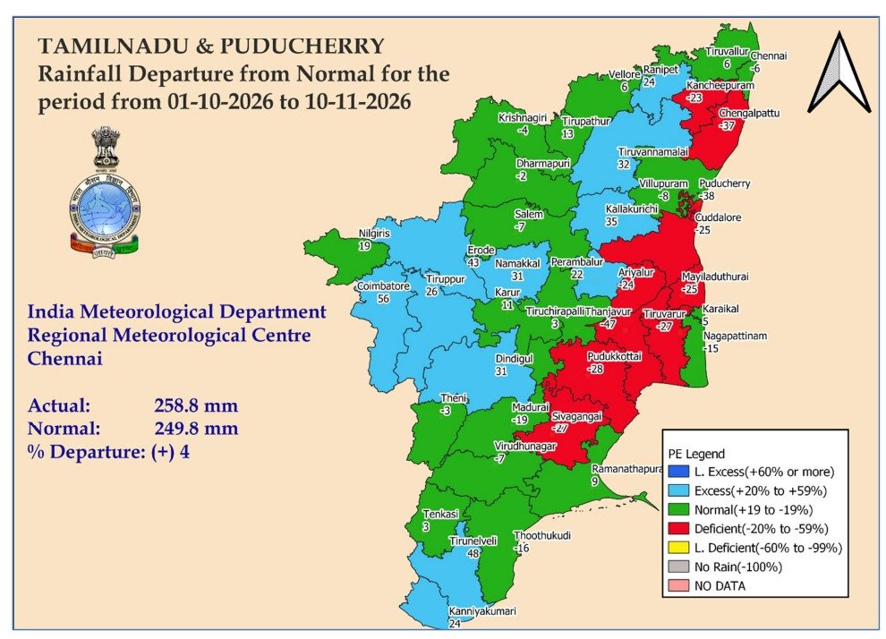
Core NEM regions aka Coastal Tamil Nadu is in significant North East monsoon deficit. South West Monsoon was also dismal across the state. The upcoming rain wave is very crucial for Tamil Nadu - if that misses, we might end up in a rare deficient year in a super El Niño background. With a super hot summer coming up, the state needs rain! #NEM2026 #TamilNadu #Climate #ElNiño #2026 #Weather
If you want to learn about my predictions, please share your number. I will make you draw a system track landfall point by using simple compass box well ahead of any global models. Telugus have highly intellectual genes... global things can never influence the Telugu genes ;))
டெல்டாவெதர்மேன் ஹேமச்சந்தர் தீபாவளி சிறப்பு வானிலை அறிக்கை| தேதி: 04.11.2026
#தலைப்பு: தீபாவளி வானிலை & 2ம் சுற்று பருவமழை அறிக்கை.
#வானிலைஅமைப்பு:
==> இன்று (04.11.2026) காலை 8:30 மணி நிலவரப்படி ஈரோடு மாவட்டம் தல்குனி 9 செ.மீ, திருப்பூர் மாவட்டம் குன்னத்தூர், ஈரோடு மாவட்டம் திங்களூர், கோயம்புத்தூர் மாவட்டம் காரமடை தலா 8 செ.மீ மழை பதிவு. திருவண்ணாமலை மாவட்டம் கலசபாக்கம் 6 செ.மீ மழை பதிவு.
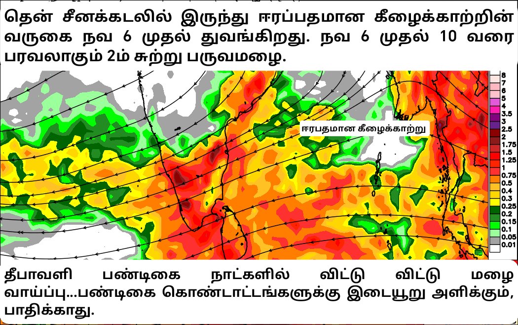
==> தென்சீனக்கடலில் இருந்து ஈரப்பதமிகுந்த கீழைக்காற்று நவம் 6 முதல் 11ம் தேதி வரை தமிழகத்திற்கு வருகை தருகிறது.
==> வடகிழக்கு பருவமழை துவங்கி, சீரான கீழைக்காற்றின் முதல் வருகையாக இது அமையும்.
#வானிலைஎதிர்ப்பார்ப்பு:
==> தமிழ்நாட்டில் இன்றும் (04.11.2026) & நாளையும் (05.11.2026) தெளிவான வானத்துடன் வெப்பமான சூழலும், ஆங்காங்கே திடிரென மேகம் சுழ்ந்து இடி,மின்னலுடன் கூடிய மழையும் பதிவாககூடும்.
(06.11.2026) முதல் (11.11.2026)
==> வடகிழக்கு பருவமழையின் இரண்டாம் சுற்று மழை நவ 6 முதல் ஒரு வாரத்திற்கு பரவலாகும் என எதிர்ப்பர்க்கப்படுகிறது.
==> கடலோர மாவட்டங்கள்,காவிரி டெல்டா, தென் மாவட்டங்கள், உள் மாவட்டங்கள், மேற்கு & மேற்கு தொடர்ச்சி மலை மாவட்டங்கள் என மாநிலம் முழுதும் சீரான மழைப்பொழிவை இரண்டாம் சுற்று மழை கொடுக்கும் என எதிர்ப்பார்க்கப்படுகிறது.
==> நவம் 7 முதல் 10 வரை தீபாவளி தினம் உட்பட காவிரி டெல்டா & தென் மாவட்டங்களில் விட்டு விட்டு கனமழைக்கு வாய்ப்பு உள்ளது.
==================================
தீபாவளி பண்டிகைகால அறிவுறுத்தல்கள்:
1. தற்போது ஆங்காங்கே பெய்து வரும் 2ம் சுற்று மழை நவ 6 முதல் 10 வரை பரவலாகும் என எதிர்ப்பார்க்கப்படுகிறது.
2. இந்த மழை தொடர் மழையாகவோ, அடை மழையாகவோ இல்லாமல் சீரான மழையாகவும்/விட்டு விட்டு பெய்யக்கூடிய மழை என்பதால் பண்டிகைகால கொண்டாட்டங்களை பாதிக்காது ஆனால் இடையூறு அளிக்கும்.
3. பண்டிகை கால பயணங்கள் மேற்கொள்பவர்கள் வெயில் அடித்தாலும் குடை, ரெயின் கோட்டுடன் வெளியில் செல்வது நல்லது.
4. பண்டிகை கால வியாபாரிகள், புதிய வெடிக்கடைகள் அமைப்பவர்கள் திடிர் கனமழையில் பொருட்கள் நனையாதவாறு பத்திரப்படுத்திக்கொள்ள வேண்டும். நல்ல வெயில் அடித்தாலும் திடிரென மேகம் சூழ்ந்து 30-45 நிமிடம் கனமழை பெய்யும் என்பதால் கடை வியாபாரிகள் விழுப்புடன் இருக்க வேண்டும்.
5. தண்ணீர் இல்லாமல் பூச்சிக்கட்டுப்பாடு, களைக்கட்டுப்பாடு பணிகளை மேற்கொள்ளாமல் காத்திருந்த விவசாயிகள் அடுத்த 2 நாட்களில் வேளாண் பணிகளை தொடரலாம்.
6. தீபாவளி விடுமுறையில் வால்பாறை, சின்னக்கல்லாறு, ஏற்காடு, கொடைக்கானல், தேக்கடி, மூனாறு, உதகமண்டலம், குற்றாலம் போன்ற மலை தொடர்கள் செல்ல திட்டமிட்டிருப்பவர்கள் தாராளமாக செல்லலாம். செல்லும் போது மழை இடையூறு இருக்க கூடும், பயணத்தை பாதிக்கும் மழை இருக்காது. அருவிகளில் குளிப்பதை தவிர்ப்பது நல்லது.
7. அர்னாப், முரசு என தொழிலுக்கு செல்லமுடியாமல் முடங்கிய மீனவர்களுக்கு நவ 10 வரை எந்தவித எச்சரிக்கையும் இல்லை மீன்பிடி தொழிலுமக்கு தாரளமாக சென்று வரலாம்.
என்றும் இயற்கையுடன்
டெல்டாவெதர்மேன் ஹேமச்சந்தர்
#diwalirains #diwali2026
Never ever underestimate the power of elnino this year.
Just a cluster of bands gives this much intense rains never seen in my entire life.
Just a low or depression stays near us could bring extreme rains for sure.
#CHENNAIRAINS
Next ,Cyclone "Akvan" will form between Nov 14-17 and move towards TN coast
Hot spots:
Tuticorin 2 chennai via delta (An ECR rider)
Accurate update on Diwali 🪔
🌀