Where is Tornado Alley, really?
There is talk that Tornado Alley has moved, or has been moving East.
Looking at the last several decades of tornado track history, we can see year-to-year where tornado hotspots form across the US.
The records do support an eastward trend.
How much of this is an artifact of better documentation and reporting? How much represents an actual climatological shift that we might see continue onward?
What do you think?
Where is Tornado Alley, really?
There is talk that Tornado Alley has moved, or has been moving East.
Looking at the last several decades of tornado track history, we can see year-to-year where tornado hotspots form across the US.
The records do support an eastward trend.
How much of this is an artifact of better documentation and reporting? How much represents an actual climatological shift that we might see continue onward?
What do you think?
Tornadoes in South America; why we've been lucky thus far:
South America is no stranger to tornadoes. We get them every year. While the frequency is not on the level of the USA, the number is still high enough to warrant precaution.
There have been several tragedies involving tornadoes in the last few decades. Rio Bonito do Iguacu, Dolores, San Pedro. Yet the relatively low urban footprint in km2 has likely helped keep highly populated urban areas away from the paths of the strongest tornadoes.
In the USA, the more space-chugging suburbs, spanning hundreds of km2 around main urban districts, make a much larger target for tornadoes and increase the statistical odds of an urban hit.
In SA, the generally more compact cities and towns, with large rural areas between many population centers, manage to reduce the statistical odds of a hit just enough to keep us away from another tragedy at the level of San Justo.
This does not mean, however, that the current level of public awareness is acceptable, in our opinion.
People in the region are widely unaware that these phenomena even occur here, and it's important to let them know how to act in the event of a tornado, and to try to get warnings closer to people living in tornado-prone regions.
Twitter/X is likely aiding substantially in getting these warnings to people who might need them. Footage of a tornado or funnel cloud in a district can quickly make the rounds and reach people living in those areas through the algorithm, giving them valuable time to prepare and seek shelter.
Thanks to PREVOTS for their work in Brazil. They have gone a long way with this in their country, and thanks to the community for spreading awareness of these events through reposting, research and general discussion.
@Ern_Nascimento@lechiciaos@prevots_svr Hey Ernani! We've been conducting a similar study using ERA5 reanalysis data and reached similar results, hit me up if you want to see some of them, we could use more expert insight!
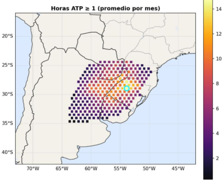
For sure! We'll be posting about it soon, but for instance here you have one of the maps pertaining to October reanalysis data (17 full Octobers analyzed, hourly).
I'm very interested now in seeing if analyzing Winter months will see the hotspot moving northeastward toward Paraná
@lucaschaser (One limitation is that our study has currently only focused on Spring months, so considering that study we could follow up with Winter months. Maybe that will produce a different variation)
Of course, we agree that the SATA is within the boundary marked in that study, but the gap itself seems to be more feasibly explained by observer bias than climatological factors.
In fact, we are currently conducting a study for which we have consulted with some meteos from UBA, aimed at isolating the observer bias component by using ERA5 reanalysis data to identify tornado-supportive environments in our region (high SRH, CAPE, bulk shear overlaps). For now we have identified RS, Brazil/Misiones/Corrientes as the most supportive hotspot, with the peak in RS, but with a continuous region rather than two separate hotspots.
We have only used traditional indexes so we'll see what other indexes produce
@gus_silvva@ampereiranunes It's possible, albeit not likely. Remember that you'd need the tornado to not only be strong enough but also hit the correct structures and do the necessary damage to be deemed F5. In Brazil the strongest tornadoes often level houses but are capped at F4 due to weak construction
@gus_silvva@ampereiranunes Low, not zero, but low. Even highly active South American years classify as somewhat normal-to-underwhelming years for USA standards. Coupled with the fact that the only F5 in SH history was 53 years ago, it would be extremely odd.
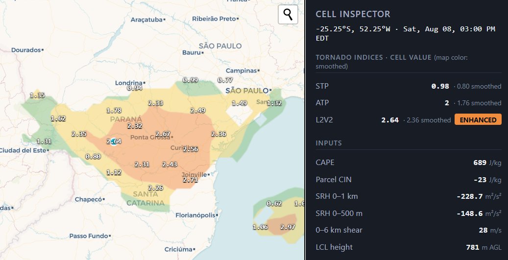
Yet another highly active tornado day in Brazil, this time in Paraná, with our L2V2 index once again providing a spatially accurate forecast for confirmed tornadoes. Catch these forecasts and more at https://t.co/RgqtdfVYTG / https://t.co/IVjHglmWIb
Our L2V2 indicator was once again highly effective in predicting likelyhood and location of confirmed tornadoes in the region. This time, in Rio Grande do Sul, Brazil, after one of the most eventful tornado weeks in a long time
@PrevisaoMasters @GoedeTDS @metsul@SMN_Argentina
Anticyclonic cycloidal markings... or cyclonic, technically?
These cycloidal markings were left behind by a strong tornado in Argentina on July 31. The photo was taken by Maximus Rosario. Because this occurred in the Southern Hemisphere, the markings are cyclonic (they would be considered anticyclonic in the Northern Hemisphere).
The tornado also completely destroyed an abandoned farmhouse, caused extensive crop damage, and inflicted severe tree damage. Based on the available evidence, the overall damage appears consistent with an F2 tornado, perhaps an F3.
Photo: https://t.co/nb6SUysWlz