The Office of Emergency Management leads the Santa Barbara County Operational Area providing coordination and direction during emergencies and disasters.
El viernes, 22 de mayo de 2026 a las 7:00PM: La Advertencia de Evacuacion ha sido CANCELADA para el area de norte de Big Pine Mountain, este de Perkins Road, al oeste de Cuyama River/HWY 33, y al sur de valle de Cuyama. Mapa: https://t.co/wimbk6SskK
As of 7PM May 22, 2026, the Evacuation Warning has been CANCELLED for the area North of Big Pine Mountain, East of Perkins Road, West of the Cuyama River/Hwy 33, and South of the Cuyama Valley. Remain vigilant of changing conditions. #FoothillFire
Map: https://t.co/snqwxE1rYK
Oficina del Sheriff: ORDEN DE EVACUACION emitida para Cuyama Valley al sureste de Perkins Rd debido a un incendio, hasta nuevo aviso. Desaloje ahora. Mapa: https://t.co/gsWirC259R
Sheriff's Office: EVACUATION ORDER issued for Cuyama Valley south east of Perkins Rd. due to a wildfire, until further notice. Leave now. Map: https://t.co/gsWirC259R
Se espera fuertes vientos este fin de semana para partes del Condado de Santa Bárbara.
🍃 Los vientos pueden derribar árboles, muebles de exterior
💡 Prepárese para cortes de energía no planificados
🔥 Evite actividades peligrosas que puedan causar chispas o iniciar un incendio
Strong winds are forecast for parts of #SantaBarbaraCounty this weekend.
🍃Winds may down trees & outdoor furniture.
💡Be ready for unplanned power outages.
🔥Avoid hazardous activities that may cause sparks or start a wildfire.
#ReadySBC
Still looking windy this weekend for #SoCal:
- W-NW wind, gusting 40-65 MPH today-Sun
* Strongest (gusts 55-65 MPH) tonight-Sun Night
* Interior sections as well as SW Santa Barbara county
- Gale force gusts (35-45 kt) across most of the coastal waters. #CAwx
Emergency management partners came together to learn about the local Red Cross mission: Disaster Action Teams, home fire response, and volunteer-run shelters. Stronger together, ready to serve. Interested in becoming a local volunteer?
➡️Sign up today: https://t.co/0Kwd9RibhO
⭐Join #SantaBarbaraCounty emergency managers and park rangers to learn more about tsunamis, what the local impacts may be, and practice your tsunami evacuation route.
Happening from 10 - 11 am on Friday, March 27, at Goleta Beach.
#ReadySBC
⭐ Acompañe a los gerentes de emergencias y a los guardaparques para aprender más sobre los tsunamis, cuáles pueden ser sus efectos locales, y practique su ruta de evacuación en caso de tsunami. El evento tendrá lugar el viernes 27 de marzo, de 10 a 11 am, en la playa de Goleta.
Tsunami Preparedness Week in #SantaBarbaraCounty, know what tsunami alerts mean:
📢 Info Statement: No threat
👀 Tsunami Watch: Possible tsunami
🚨 Tsunami Advisory: Stay out of the water
🌊 Tsunami Warning: Evacuate
Learn more: https://t.co/VdzRyJ1art.
#ReadySBC
Semana de preparación ante tsunamis:
conozca el significado de las alertas
📢 Boletín informativo: No hay amenaza
👀 Vigilancia de tsunami: Posible tsunami
🚨 Aviso de tsunami: No entre al agua
🌊 Alerta de tsunami: Evacúe
https://t.co/VdzRyJ1Ih1
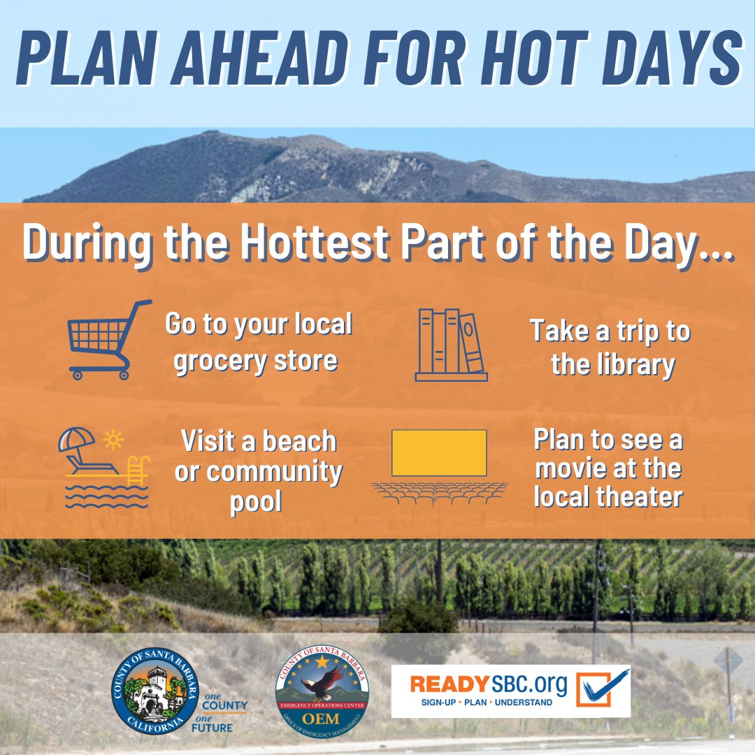
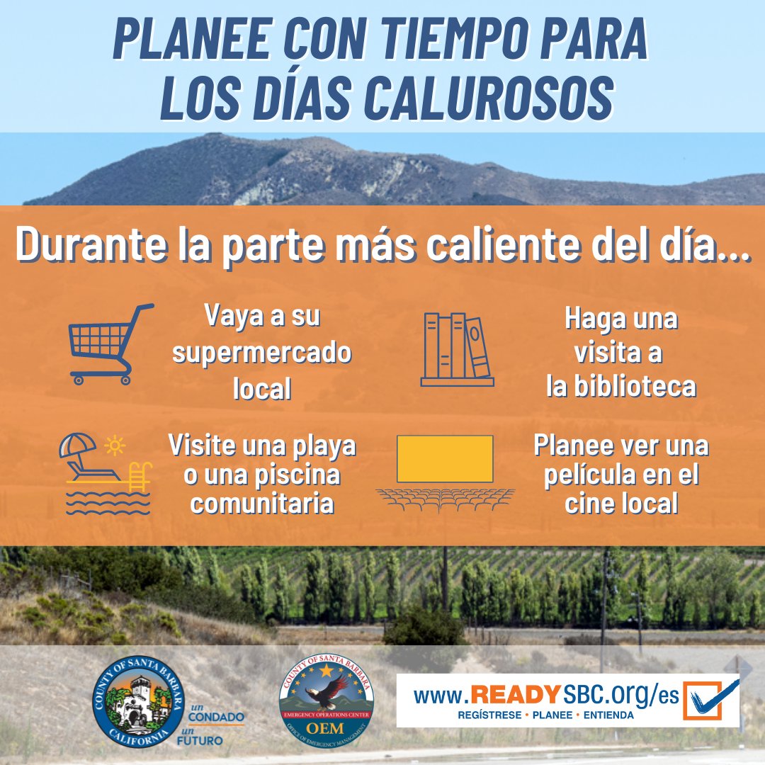
🥵 Temperaturas más altas ocurriendo del 17 al 20 de marzo de 2026 en partes del Condado de Santa Bárbara.
➡️ Consejos para combatir el calor: https://t.co/YqDKvUxB7m
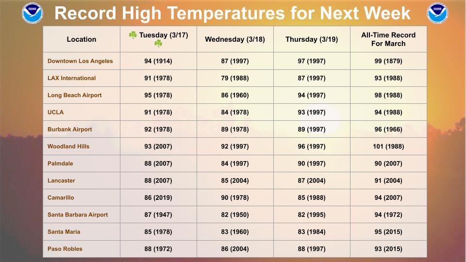
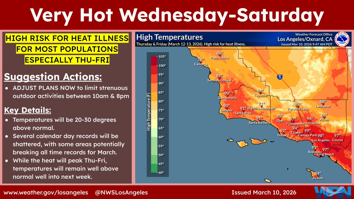
Here is a table of record high temperatures for next week. The hottest temps are expected Tue-Thu when monthly records for March could fall. #LAHeat#SoCal#CAwx
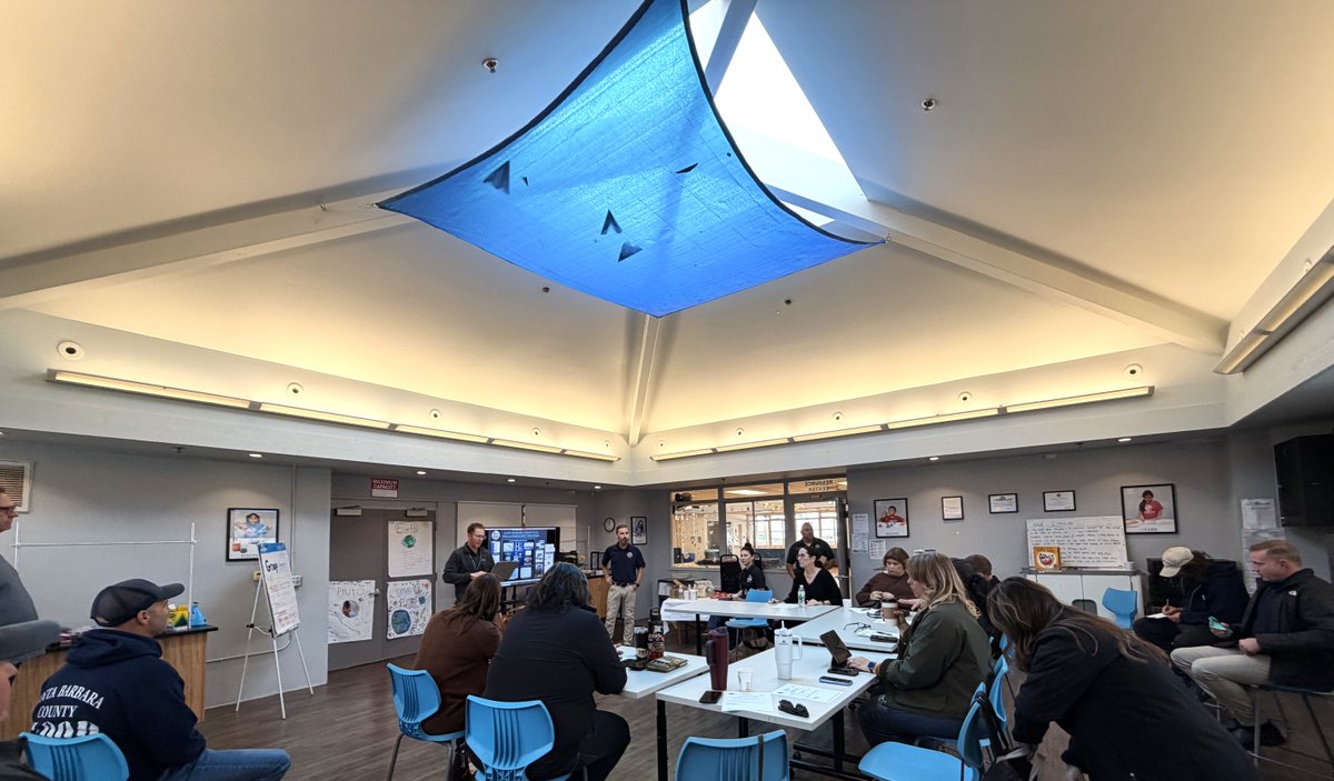
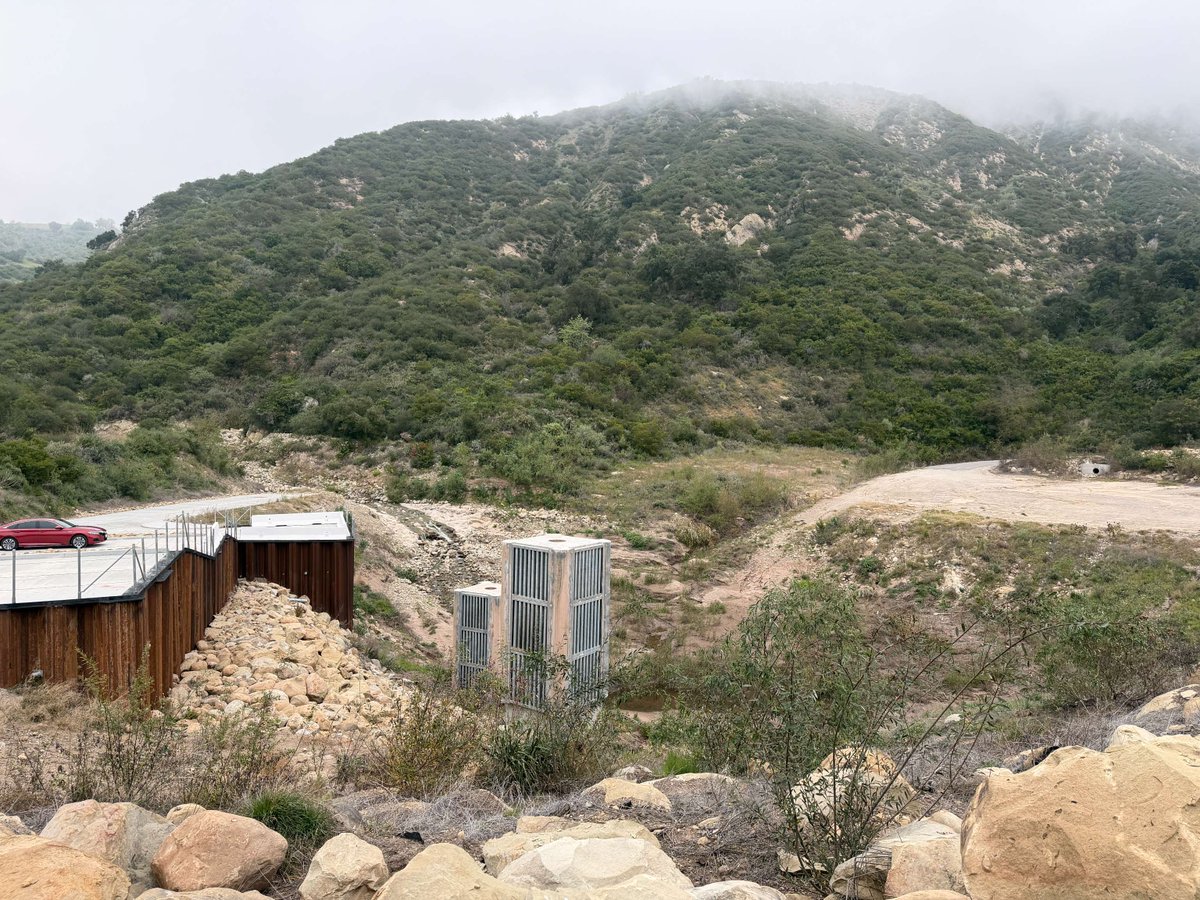
Gerentes de emergencias se reunieron en Carpinteria para aprender del Control de Inundaciones sobre medidores de arroyos, embalses y lluvia, y datos de tormentas en tiempo real; luego visitaron la Cuenca de Escombros Santa Monica. ✨La preparación comienza antes del desastre.
Emergency managers met in Carpinteria to learn from County Flood Control about creek/reservoir/rain gauges, & real-time storm data, then toured the Santa Monica Debris Basin to see how it protects homes from flooding & debris flows.
✨Preparedness starts before disaster strikes.
Be prepared by knowing what could happen where you live. The Community Hazard Awareness Map helps you plan ahead.
Esté preparado sabiendo qué podría suceder donde vive. El mapa de información sobre riesgos comunitarios le ayuda a planificar.
📍 https://t.co/TiUUdSqOVd