منقول: خمس مواقع موثوقة لتحميل بيانات نظم المعلومات الجغرافية(GIS) مجاناً
5.Copernicus Open Access Hub
https://t.co/zaMr0wKlSl
يوفر بيانات الأقمار الصناعية من بعثات Sentinel الأوروبية، تشمل صوراً عالية الدقة.
منقول: خمس مواقع موثوقة لتحميل بيانات نظم المعلومات الجغرافية(GIS) مجانة:
https://t.co/rV0vwuOri8 Explorer - هيئة المسح الجيولوجي الأمريكي
https://t.co/VPENydWojQ
يوفر صور الأقمار الصناعية وبيانات الارتفاعات والخرائط الطبوغرافية.
2.Natural Earth
📷https://t.co/DxpB1Mrnl9
منقول: خمس مواقع موثوقة لتحميل بيانات نظم المعلومات الجغرافية(GIS) مجاناً:
3.OpenStreetMap (OSM)
https://t.co/w85E1njD1H
قاعدة بيانات مجتمعية مفتوحة، توفر بيانات شاملة للطرق، المباني، والنقل وغيرها.
https://t.co/qdje3A5gvq
Land Cover Facility (GLCF)
https://t.co/B0n4xvr8wM
17. Python and Water Stress: https://t.co/crsRr9Ofmg
18. Python and Water Scarcity: https://t.co/z6lUDYMg3Z
19. Python and Thermal Sharpening: https://t.co/dViG2hTNdF
20. Python and ET Prediction: https://t.co/acw0R2xEm9
21. Python and Air Pollution: https://t.co/AV0K023ltj
HOW TO MAKE A MAP LIKE THIS ONE IN QGIS:
1. Download the SRTM 1 Arc-Second Global data for your region of interest from the USGS Earth Explorer website (https://t.co/NC9hoY5NjI).
2. Build a virtual raster in QGIS if you have several tiles.
من أقوى أدوات توفير الأوراق البحثية
أصبح تدعم اللغة العربية
https://t.co/13Ef3zEtAb
هذه الأداة تم تطويرها من قبل خريجي معهد ماساتشوستس للتكنولوجيا وهي أقوى محرك بحث مدعوم بالذكاء الاصطناعي للأدبيات العلمية.
بعد أن تدخل سؤالك البحثي راح توفر لك الكثير من دراسات المرتبطة بسؤالك (متغيرات دراستك) مع تقديم نسبة ارتباط كل دراسة بمتغيراتك.
والجميل أنها تعطيك اشعارات عند توفر أوراق جديدة مرتبطة بهدفك
كما أنها تختصر الوقت في تصفحها من خلال تنظيمها وفق عدد من المحددات وكتابة تقرير حولها… ومع إمكانية تصدير البيانات
المميز أنه يعطي مراجع حقيقية لكل فكرة يقدمها لك وبشكل منظم، وينظم لك عملك البحثي كامل
تقدم تجربة مجانية محدودة
From raw satellite pixels to real land-cover insights. Maximum Likelihood Classification helps us decode the Earth — one probability at a time. 🌍📊 #Sentinel2#GeoAI#MegaMapping
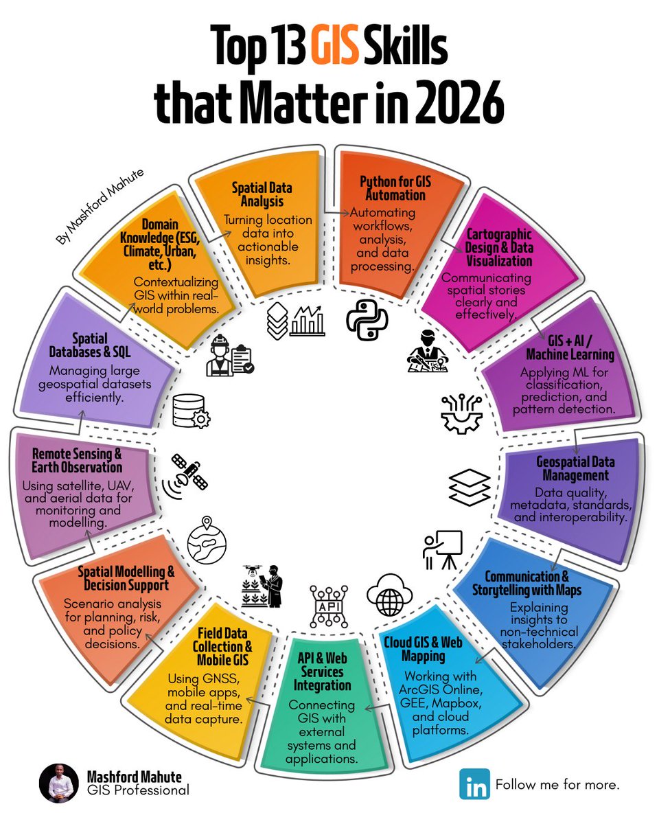
The GIS professionals who will thrive in 2026 are the ones who can:
- automate workflows
- work with cloud and satellite data
- connect GIS to real-world decisions
- clearly explain why location matters
That’s why I created this infographic:
Top 13 GIS Skills That Matter in 2026
Urban Expansion Mapping using Google Earth Engine
Full tutorial link:https://t.co/nf4e2NPpp1
Registration link: https://t.co/O4AcVIerFn
#googleearthengine#GeoAI#gis#remotesensing