I've been on a journey moving from point-and-click GIS tools to working almost entirely in SQL, and it is 💯 but what isn't 💯 is the available guidance for common geo workflows in SQL, so I've written my own!
"How to SQL: a Guide for GIS Users" #GIS#SQL
https://t.co/8J3cSHVrhT
For much of the last 20+ years that I've worked with Victorian municipalities, I've spent trying to help them get their critical property information into Vicmap.
I invite every GIS professional working for a Victorian council to read about our plan and provide us with feedback!
@opencholmes@opengeospatial@pwramsey Great write up! Regarding limitations of GeoPackage, could there be a way of streaming it using this approach: https://t.co/T6XkzURdtd
Check out this demo: I run the SQL query "select country_code, long_name from wdi_country order by rowid desc limit 100" and it fetches just 54.2KB of new data (across 49 small HTTP requests) to return 100 results - from a statically hosted database file that's 668.8MB!
Just celebrating our successful series K (special) round - we’re very excited about what’s about to rock the geospatial industry in 2022. Be ready @esriaustralia @SpatialVisionAU @Geoplexing@gruntify @PoziApp
I use mostly free software, but today I was happy to pay for @Typora which has just come out of beta. It's a Markdown editor that makes writing enjoyable. Almost all writing I do that's not an email starts off as note in Typora.
We've leveraged the amazing #GeoStyler project to enable clients to style their layers using QGIS and display them in Pozi. It sure beats maintaining our own custom styling workflow!
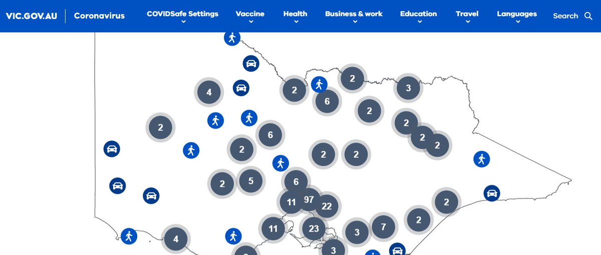
The Victorian state government COVID test site map, and a whole range of other online maps, are currently missing their basemap due to a problem this morning with the Vicmap basemap service. We've switched our Victorian clients over to OpenStreetMap until it comes back up again.
@mrdougal I still remember the book you lent me that said that IE4 was a step in the right direction. I can't imagine what kind of mess the previous ones must have been!
I'm so happy to be getting rid of support for IE!
Our new development cycle:
1. develop and deploy Pozi update
̵2̵.̵ ̵f̵i̵n̵d̵ ̵o̵u̵t̵ ̵t̵h̵e̵r̵e̵ ̵i̵s̵ ̵a̵n̵ ̵i̵s̵s̵u̵e̵ ̵i̵n̵ ̵I̵E̵
̵3̵.̵ ̵c̵r̵e̵a̵t̵e̵ ̵w̵o̵r̵k̵a̵r̵o̵u̵n̵d̵ ̵f̵o̵r̵ ̵I̵E̵
̵4̵.̵ ̵r̵e̵d̵e̵p̵l̵o̵y̵ ̵u̵p̵d̵a̵t̵e̵
Community!!🚀⚡
ONLY FOR 24 HOURS - ONLY TODAY until 23:59 time in Argentina our tickets are 50% OFF 🎟️💥
In your ticket purchase enter the code FOSSFRIDAY or use this link directly: https://t.co/j6DNSfLXxM
RUN!! 🏃🏻
@OSGeo#fossfriday#opensource#gischat@GISchat@osgis
@Xtrackka @Data_Vic@VicGovAu @DETVic Here was my attempt at an alternative solution a few years ago, creating zones by grouping together census blocks by which school has the shortest travel distance.
https://t.co/ins6JtXFjI