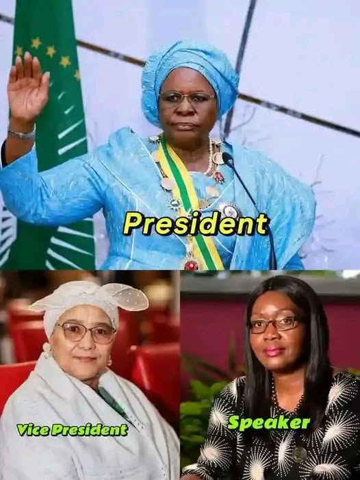
Namibia 🇳🇦 is the only country in the world with a female President, Vice President, and Speaker of the National Assembly.
Happy International Women's Day 2026!
#IWD2026#InternationalWomensDay
@HELBpage It's only that our hands are still tied, we'll willing pay this when in a position to because without your support some of us won't have made it! 🙏
Kenya Medical Research Institute (KEMRI) Hiring
Positions
1. Driver
2. Data Clerk
3. Administration and Operations Coordinator
4. Research Assistant
5. Study Nurse
6. Data Manager
7. Study Doctor
8.Field Technologist
Apply
https://t.co/lMTNArsgY2 #IkoKaziKE
Surveying • GIS • Mapping — Understanding the Difference and How They Work Together
These three disciplines often get mixed up, yet each plays a unique role in the geospatial world. Here’s a simple breakdown of what they are, what they do, and where they are used — and how they come together to build the spatial intelligence we rely on every day.4
📍 Surveying
Surveying is the science of precisely measuring positions on the earth.
It focuses on capturing accurate coordinates, distances, elevations, and boundaries using tools like total stations, GNSS, and laser scanners.
Key applications:
🔹 Land boundary establishment
🔹 Engineering & construction layout
🔹 Infrastructure development
🔹 Topographic data collection
🔹 Monitoring deformation (bridges, dams, structures)
Where it’s used:
- Real estate & land administration
- Roads, bridges, buildings
- Utility installation
- Any project requiring centimeter-level accuracy
🗺️ GIS (Geographic Information Systems)
GIS is the technology that stores, manages, analyzes, and visualizes spatial data.
It brings together layers such as parcels, imagery, roads, utilities, elevation models, and more.
Key applications:
🔹 Spatial analysis & modeling
🔹 Asset management (water, electricity, telecom)
🔹 Environmental monitoring
🔹 Urban planning
🔹 Disaster management & risk assessment
Where it’s used:
- Governments & planning departments
- Utilities & infrastructure agencies
- Agriculture, health, environment
- Organizations managing location-based data at scale
🖊️ Mapping
Mapping is the process of turning spatial data into visual products—maps, plans, charts, or digital cartographic outputs.
Key applications:
🔹 Topographic maps
🔹 Engineering plans
🔹 Thematic maps (land use, zoning, hazards)
🔹 Navigation maps
🔹 Story maps & visual communication
Where it’s used:
- Survey firms
- Cartography departments
- NGOs & research organizations
- Any place needing clear, readable spatial communication
🤝 How They Work Together
These disciplines are interconnected and complementary:
Surveying collects the raw, accurate ground measurements.
GIS organizes, analyzes, and integrates that data with other spatial datasets.
Mapping communicates the results visually for decision-makers and the public.
Together, they form a complete geospatial workflow — from field measurements to analysis to final map outputs. This integration powers modern infrastructure, smart cities, environmental management, and nearly every sector that depends on spatial intelligence.
🔵 Orion Terrametrics
At @OrionGeospatial, we combine these three pillars into a unified approach—delivering precise surveying, intelligent GIS solutions, high-quality mapping outputs, and modern geospatial platforms tailored for Africa’s infrastructure and development needs.
Transform your spatial data into real decisions.
Learn more: https://t.co/YegwOYJXIV
CONFIRMED:Gen z has Created a Peoples IEBC Where someone can upload form 34As and the system will tally results Automatically,These are the Brains the Opposition needs to make Kasongo WANTAM.
“UNITED WE STAND AGAINST DICTATORS.”
The flags visible in the image include those of:
1.Zimbabwe 🇿🇼
2.Mozambique 🇲🇿
3.Nigeria 🇳🇬
4.Kenya 🇰🇪
5.Tanzania 🇹🇿
6.Uganda 🇺🇬
7.Cameroon 🇨🇲
8.South Sudan 🇸🇸
9.Djibouti 🇩🇯
10.Niger 🇳🇪
11.Guinea 🇬🇳
If we do not act, Kenya will be as horrible as Uganda and Tanzania now. Bob Njagi and Nicholas Oyoo must be released by the Government of Uganda, and brought back home by the Government of Kenya.