How toxic were the ancient Maya's lakes?
Mud from two lakes in Yucatán shows mercury far above today's toxic limits. It lasted for centuries in the Classic Maya era (250–920 CE).
Find out: https://t.co/XC5HocoHkh
Image: Calakmul, Lugares INAH, CC BY-SA 4.0
Good update from UK’s SolarSteph this morning. The sun does not appear to have been the cause of the nationwide FAA Ground Stop last night. Hacking or incompetence?
Today's aurora and space weather 3-day forecast! 🌌 C5.5 flare last night as active region 4566 rotates off the Sun, with a 20% chance of M flares ☀️💥 Solar wind stays slow, so no storms 🌬️ Aurora: unlikely in Scotland next 3 nights💚👀 #spaceweather#aurora
What's hiding beyond the giant planets? 12 dust grains caught in Earth's stratosphere point to a reservoir of heavy-oxygen ice out there!
Find out: https://t.co/JG5pEwTDcu
Image: NASA, example grain
A 1922 map showed an inner wall at Pinson Mounds in Tennessee. Was it ever there?
https://t.co/OPMG9VYAza
A magnetometer survey found no sign of it, but one method alone can't fully rule it out. The mounds date to about 1–500 CE.
Photo: Brian Stansberry, CC BY 3.0
Before Göbekli Tepe (11,600 years ago), people in today's Israel made clay animals and people.
A Nov 11, 2026 study reports 15 figurines from 15,000-11,650 years ago!!
https://t.co/D9PqDTftDx
Image: Davin et al., CC BY 4.0
Were Cape Trafalgar's tombs among Iberia's last megaliths?
Similar tombs in the region date to the 3rd millennium BC. A Nov 11, 2026 study proposes these two were built later, in the early 2nd millennium BC.
Find out: https://t.co/uFUJXybuJN
Image: Vijande-Vila et al., CC BY 4.0
Do not stare at Leo. Look 30-45 degrees to the side.
https://t.co/8aSGjQncVk
The Leonid radiant is in the Sickle of Leo, east to southeast. Best hours: 12:30-5:30 AM local Wed Nov 18, after moonset on Tue night Nov 17. Scan toward Gemini or Orion.
Photo: Ed Sweeney, CC BY 2.0
You're right about one part of it. Robert Mainfort's excavations showed that several of the smaller "mounds" and most of the "breastworks" an early surveyor recorded at Pinson are actually natural landforms or farm features. So the idea that people worked with the natural landscape there fits.
The bison part runs into a timing problem. Pinson was built and used between about AD 1 and 500. Bison don't show up east of the Mississippi until roughly 1450–1700, more than a thousand years later. Radiocarbon-dated bison bones in the Ohio Valley start around AD 1450, and the National Park Service records Tennessee's last bison in 1823. The digs also point to ceremony: the main mound is a 72-foot flat-topped platform, and the finds are pottery that visiting groups brought from far away, with no animal-kill deposits. Hunters of that era were more likely to have used spear-throwers or bows more than downward thrusts (hard to get that angle, works when you do).
A related question that does hold up is how the builders used the natural rises and the river bluffs. I’ll look into that also!
Multiple CMEs can merge into one very intense storm.
https://t.co/BrqWdwbO66
Storm risk isn't just giant flares. Overlapping waves can hit together. Strong storms could strain grids, stress satellites and make GPS flicker. Merging may also shift arrival forecasts.
Image: NASA/SDO
The Leonids peak in 5 nights. Plan now.
https://t.co/rXWirsY4yv
IMO peak: 6:45 PM EST Tue Nov 17. The 55%-lit Moon sets around midnight. Look about 12:30-5:30 AM Nov 18, Leo in the east. Up to about 15 an hour in ideal dark skies; fewer in practice.
Photo: Ed Sweeney, CC BY 2.0
An M1.7 flare peaked Nov 11 at 4:21 PM EST.
https://t.co/9gSgnxBB2v
NOAA assigns it to region 4566. NOAA has not reported an Earth-directed CME.
Image: NASA/SDO, public domain
What was the dark band in this once-sealed vat?
https://t.co/ZHKAOGn0jk
In 1905 at Zawyet el-Aryan, Barsanti found an oval granite vat still plaster-sealed. It was empty except for a ~10 cm dark band. His report does not record a test.
Photo: A. Barsanti, 1905, public domain
EARTH'S DISASTER CYCLES PART 5
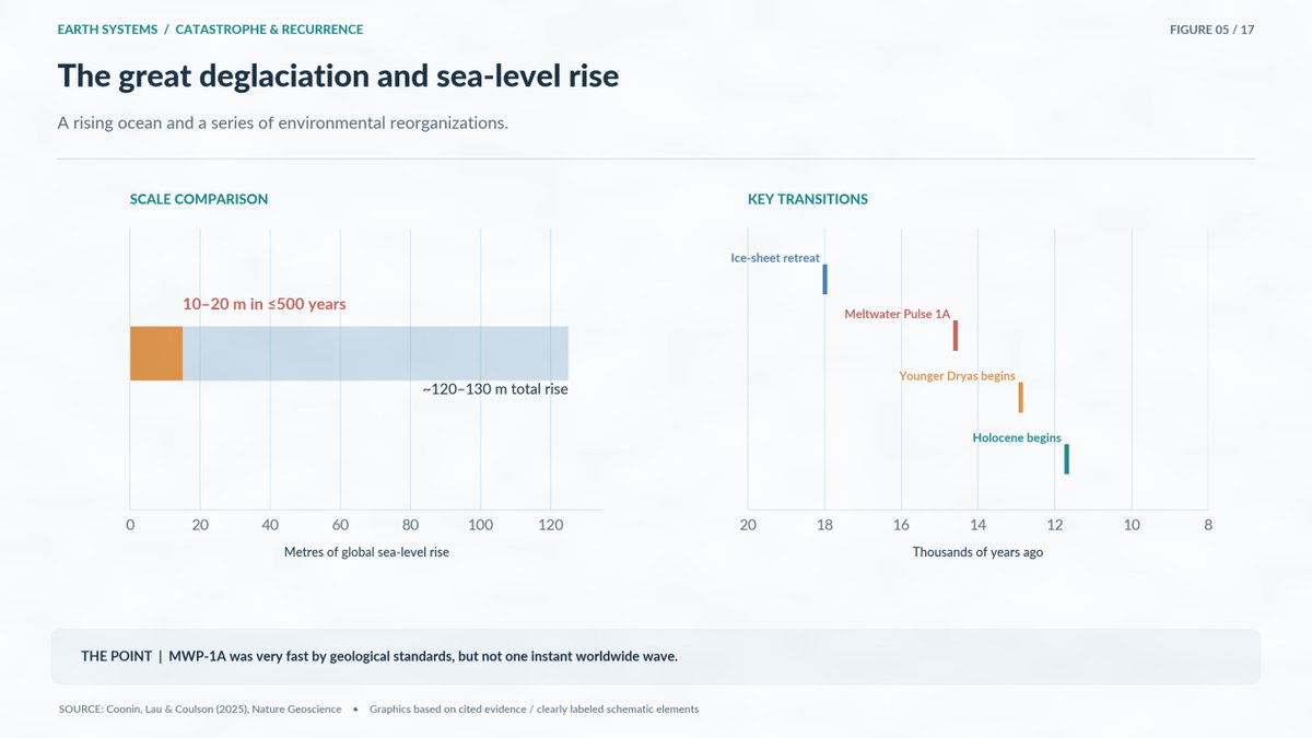
14,600 YEARS AGO, EARTH'S OCEANS BEGAN RISING AT AN EXTRAORDINARY RATE
There is a period in Earth's history that I think deserves far more public attention.
Around 14,600 years ago, during the last great ice-sheet retreat, sea level rose approximately 10 to 20 metres in an interval lasting no more than about 500 years.
Scientists call it Meltwater Pulse 1A.
We have physical evidence preserved in ancient shorelines, marine deposits, and coral records.
A 2025 study in Nature Geoscience examined where the water came from and how the loss of ice across different regions contributed to the rise.
Now consider what this would have meant for people living at the time.
During the last ice age, sea level had been roughly 120 metres lower than today.
Enormous areas that are now underwater were once dry land.
Coastal plains stretched far beyond modern shorelines. Rivers followed different courses. Landscapes existed that have since disappeared beneath the oceans.
As the ice sheets melted, those environments changed.
Not in one worldwide tsunami, but through sustained sea-level rise that could transform coastlines within generations.
In North America, huge ice-dammed lakes repeatedly burst, sending catastrophic floods across the Pacific Northwest.
Those floods happened again and again as the ice dams rebuilt and failed.
This is where my interest in ancient flood traditions meets the geological record.
We know enormous floods occurred. We know coastlines disappeared. We know human populations were living through these changes.
What we don't yet know is how much of that experience survived through oral history.
I believe that question deserves a serious investigation grounded in archaeology, geology, and the actual dates.
Two infants shared a burial pot in Nasca-period Peru. One had one central eye socket!
https://t.co/THxbIDBgSr
Cyclopia is extremely rare; find out more!
Study: Tomasto-Cagigao et al. 2026