Drone video reveals extreme forest destruction in Franklin County southeast of Roxie, Mississippi after a significant tornado tore through the area last night. A Tornado Emergency was in effect at the time, and you can see just how intense it was in this area. I estimate the damage path was nearly a mile wide here…
@ryanhallyall@WxWiseApp
#Missippi #Tornado #SevereWeather
Looking ahead to June we are expecting severe weather occurrences to be below normal through the great lakes region and the south, while the Plains and East Coast are expected to see above normal!
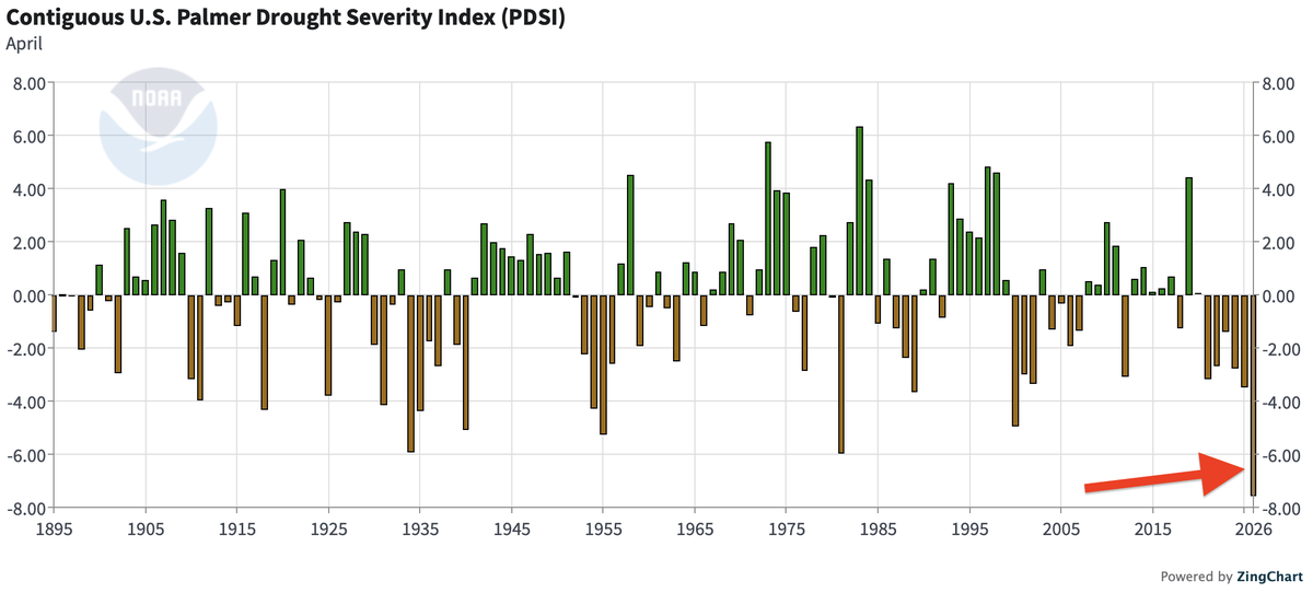
This is unprecedented.
99.8% of the Southeast US is now in drought, obliterating the previous record of 87%.
94% is in severe drought (previous record: 71%).
By far the worst drought the region has seen in the 21st century.
⚠ We are monitoring the risk for a more notable severe weather threat on Monday.
The mix of a powerful low pressure, strong jet stream and gulf moisture lead to a favorable set up for ALL modes of severe weather.
⛈️Storms this afternoon are expected to evolve into an impressive line, with damaging winds of 70mph, large hail, and a few tornadoes to be possible! As storms reach the Mississippi River they will quickly lose intensity.
I'm getting concerned that we could have a multi-day Tornado Outbreak on our hands Saturday - Monday this weekend.
The environment will be JUICED with Storm Fuel, ample Wind shear, and mega Moisture, all leading to rotating Supercells.
We will need to watch this like a hawk 🦅
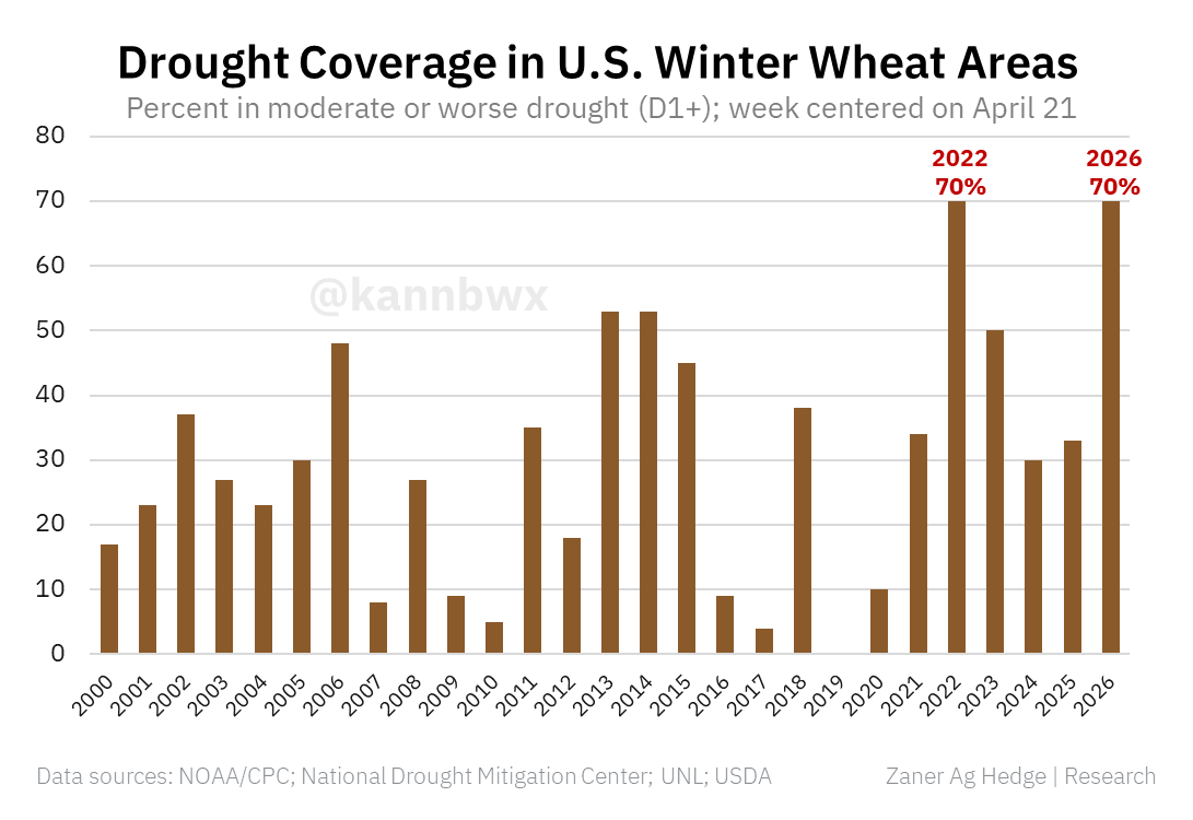
🇺🇸70% of U.S. winter wheat areas are now in a drought, tying 2022's record for the week. That's also the highest level of drought coverage across winter wheat areas for any week since December 2022.
The TX/OK panhandle region worsened this week, and the forecast isn't generous.
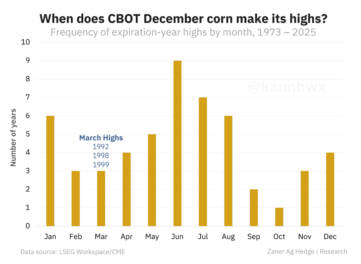
📈Dec corn's annual high sits at $4.98-1/2 per bu, set on March 9. But March highs are rare - last one was in 1999. Nov soybeans' current high also falls in the second week of March.
The last time new-crop corn & soy both set annual highs in March? Never (at least since 1973).
🌩️ SEVERE WEATHER POSSIBLE ON FRIDAY AND MONDAY
🟩 FRIDAY (04/24)
Well, Friday has decided that it did not want to be left out, so the SPC has now issued all of Southern Middle Tennessee under a Marginal Risk. A storm system moving in from the west on Friday will still have some energy left as it treks through Tennessee. The main concern is sporadic wind and hail events through the overnight hours. This will not be widespread and is a low-end possibility.
🟨 MONDAY (04/27)
As you can tell by the graphic, the SPC has trimmed back the eastern edge of the 15% from yesterday. The fine-tuning of the risk area will happen every day leading up to Monday. Areas will be trimmed and the may added back. I've seen it happen many times. Latest forecasts still are favorable for severe weather to occur on Monday. I'll just remind everyone that just because your county is out of the risk area doesn't mean your risk is zero. Storms can act like toddlers trying to color. They don't stay in the lines very well.
Right now everything is still being monitored, so please check back to Southern Tennessee Weather with all the latest as it occurs. I'll have more about this in depth this evening with the latest edition of "The Look Ahead."
-Support Meteorologist Christopher King
___________________________________
🚨 MID-STATE TOWING 🚨
This weather update is sponsored by Mid-State Towing, a locally owned and family-operated towing service proudly serving Coffee County and surrounding communities. Available 24/7, their professional flatbed operators provide fast, dependable towing and emergency roadside assistance when you need it most.
With more than 25 years of experience in collision repair and insurance claims, their team understands how stressful accidents can be and is committed to helping customers every step of the way!
Tennessee currently holds the No. 1 overall recruiting class in College Basketball 🍊
The #Vols rank No. 1 overall, No. 12 in high school, and No. 4 in the transfer portal rankings per 247Sports.
F Ralph Scott - 4⭐️ HS
F Manny Green - 4 ⭐️ HS
G Marquis Clark - 3 ⭐️ HS
G Tyler Lundblade - 4⭐️ Transfer
G Dai Dai Ames - 4⭐️ Transfer
C Miles Rubin - 4 ⭐️ Transfer
G Jalen Haralson - 4⭐️ Transfer
F Christopher Washington Jr. - 4⭐️ HS
G Terrence Hill Jr. - 4⭐️ Transfer
Rick Barnes has added five .92 grade or higher players in the portal, and holds four commits out of high school.
The 2026-27 Vols could be special.
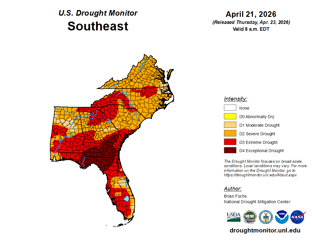
Well… here we go again. The latest Drought Monitor was released this morning, and unfortunately the news is not what we wanted. Most of Southern Middle Tennessee has now been upgraded into a SEVERE DROUGHT category. That means the dry stretch we’ve been stuck in isn’t just annoying anymore… it’s starting to have real impacts on soil moisture, vegetation, and overall fire risk.
Now for the slightly better news. There are still signs that this stubborn pattern may finally begin to loosen its grip as we head toward the end of the month. The latest Climate Prediction Center outlook continues to favor our area with a greater than 50% chance of above-average precipitation. That doesn’t guarantee soaking rains, but it does tell us the pattern is at least trying to trend in the right direction.
In the short term, we do have some rain chances to talk about. We’re expecting roughly a half inch to maybe an inch of total rainfall over the next 7 days. Our first opportunity arrives this evening, though this setup is far from a sure thing. Some folks will pick up a quick shower or storm, while others may watch it go around them entirely. Christopher had a great update this morning on the page about the storm risk today.
Additional chances arrive Saturday evening into the overnight hours, and those may be a bit more widespread. Still not a drought-buster, but at this point we’ll take anything we can get.
The bottom line is this: the upcoming rain should help a little with soil moisture and may ease fire weather concerns just a bit. But when it comes to streamflows, reservoirs, and the bigger picture drought… we’ve got a long way to go.
We need multiple rounds of steady, soaking rain. Not these hit-or-miss drive-bys… And for now, we’re just not quite there yet.
______________________
🔥 REDD’S HEATING AND AIR CONDITIONING 🔥
This weather update is sponsored by Redd’s Heating & Air Conditioning, proudly serving our community for over 50 years. Family-owned and operated, Redd’s specializes in dependable heating and cooling solutions to keep your home comfortable through the above-average Tennessee temperatures like we’re seeing this week. If your system needs service, repairs, or routine maintenance, their experienced team is ready to help. Give them a shout today and tell them Elijah sent you!
📍 704 Blue Ribbon Pkwy, Shelbyville
📞 (931) 684-0339
🌐 https://t.co/yrYcIkaAkS
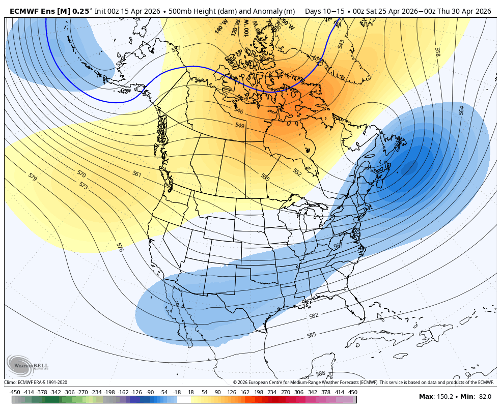
A much needed pattern change is beginning to show up for the Southeast. This will bring the return of widespread rain / storm chances for the region. We will still have to wait until the last few to several days of April, but this change is gaining momentum that it'll actually happen.
The Euro shows an active period beginning in the day 7-10 range.
Sadly with the cool down there is still no appreciable chance of rain for the far eastern USA, mainly from Appalachia east. The new drought monitor is out later this morning. I expect things to be worse with very little rain over the next 10 days overall here.
On the other hand, another decent storm due into northern CA starting Sunday where drought improvement for the month continues after the horrific March heatwave.
Maybe the east will reverse their fortune in May...
With planting underway across many of the southern states, now is a great time to check out the growing degree day forecasts ahead (GDU). We are expecting widespread above to much above normal GDUs over the next 10 days.
You can monitor GDUs interactively on Clarity's radar and track for your precise field!
Try it out with Clarity Ag: https://t.co/McYB3rdypt.