I know sirens are sounding across all of Marion County.
The tornado warning (and rotation that's transitioned to straight-line) is for eastern Hendricks/southwest Indy.
Long-line of storms continues to prompt warnings...60 mph gust...wind damage...and many power outages.
6-11-2026 at 9:30pm Radar shows a line of severe storms is moving across the Western Portions of Indiana. It includes multiple tornado warnings. More in the short video. At current pace it will reach the County around 11pm or so. If I need to go live on Facebook I will. #MadCoWx #INwx
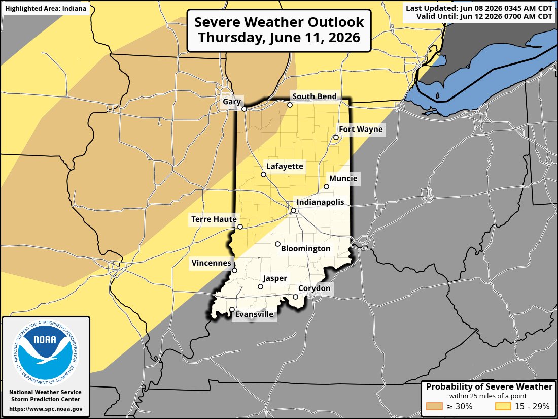
SPC has most of Central Indiana including Madison County in a Slight Risk for Severe this evening into the overnight hours. Damaging winds are the main threat but ALL MODES of severe are possible. Current timing appears to be in the 11pm to 1am time frame. #MadCoWx#INwx
Two separate computer models pinning down the timing for healthy storms inbound tonight!
Be sure to check in with @BrianWilkes59wx between 4 and 7:00pm for latest timing!
Main threat remains wind damage with gusts up to 70 mph! @fox59@theWXauthority
Good morning, #Indy. AM showers will dissipate & most of our Thursday will be storm/ rain-free. The quiet times don’t last long as another round of strong-severe storms arrives this evening. Damaging straight line winds are the greatest concern. Hot & humid today w/ highs ~ 90°.
Bumpy night but ahead: Keeping close tabs on upstream storms currently in #IAwx, #MOwx, and #ILwx this evening. These likely rumble across central #INwx during the early overnight (midnight to 4a) west to east. #Indy#AGwx
Noisy evening in progress.
Swath of 2”-4”+ rainfall in path of this complex with pockets of 60+ mph gusts.
Should reach Indy by 9-9:30 pm with nasty storm ahead of it.
Be Weather Aware and ready to get indoors.
Areas of flooding increasing next several hours.
Hot temperatures in the lower 90s combined with high moisture will lead to heat indices from 98-103 degrees both Wednesday and Thursday afternoons. In addition to the heat, there is a slight chance for storms Wednesday evening. Strong to Severe Storms expected Thurs Night. #inwx
When God calls you to something, He takes responsibility for making a way. Your part is simply to trust and go.
Watch "Walking in the Favor of God - Part 2" now: https://t.co/XAO9arf86U
Check local listings: https://t.co/C9QCTTm5SC
Heat wave this week to major cool down next week. Can't say I'm surprised we are going to see a major cool down, fits the El Nino pattern. El Ninos typically feature summer cool shots. I wouldn't be shocked at all to see more potent cool shots this summer than frequent heat waves
Rinse and repeat pattern in the days ahead with a “smattering” of storms, most numerous during the afternoon/ evening. SPC highlights a severe threat for a portion of #INwx each day, highlighted by Thursday’s potentially more widespread event. #Indy#AGwx
The first 90s of the season are likely second half next week. Storm chances the next few days. Signs still point to a big cool down just beyond the 7-day Forecast
Today we honor all the brave men who served on D-Day 82 years ago. Never forget! 🫡
#INwx
Refreshing air mass overhead very much like early June 2023. Low humidity allows temps to crash at night and warm in the day. Highs in the upper 70s to 80 this afternoon. Enjoy the next few days friends! We have storm chances on the rise for the weekend and early next week
#INwx