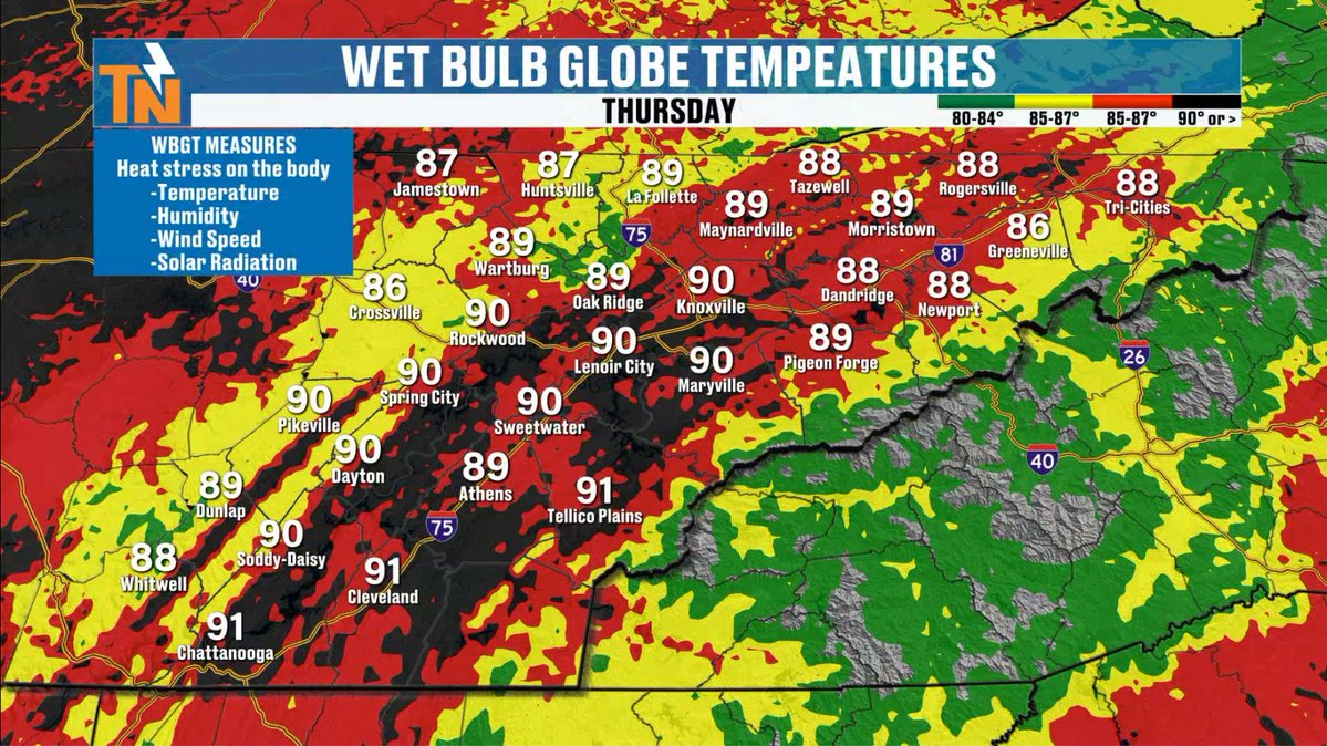
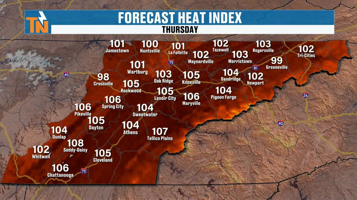
Thursday is likely going to be the hottest day of this heat wave!
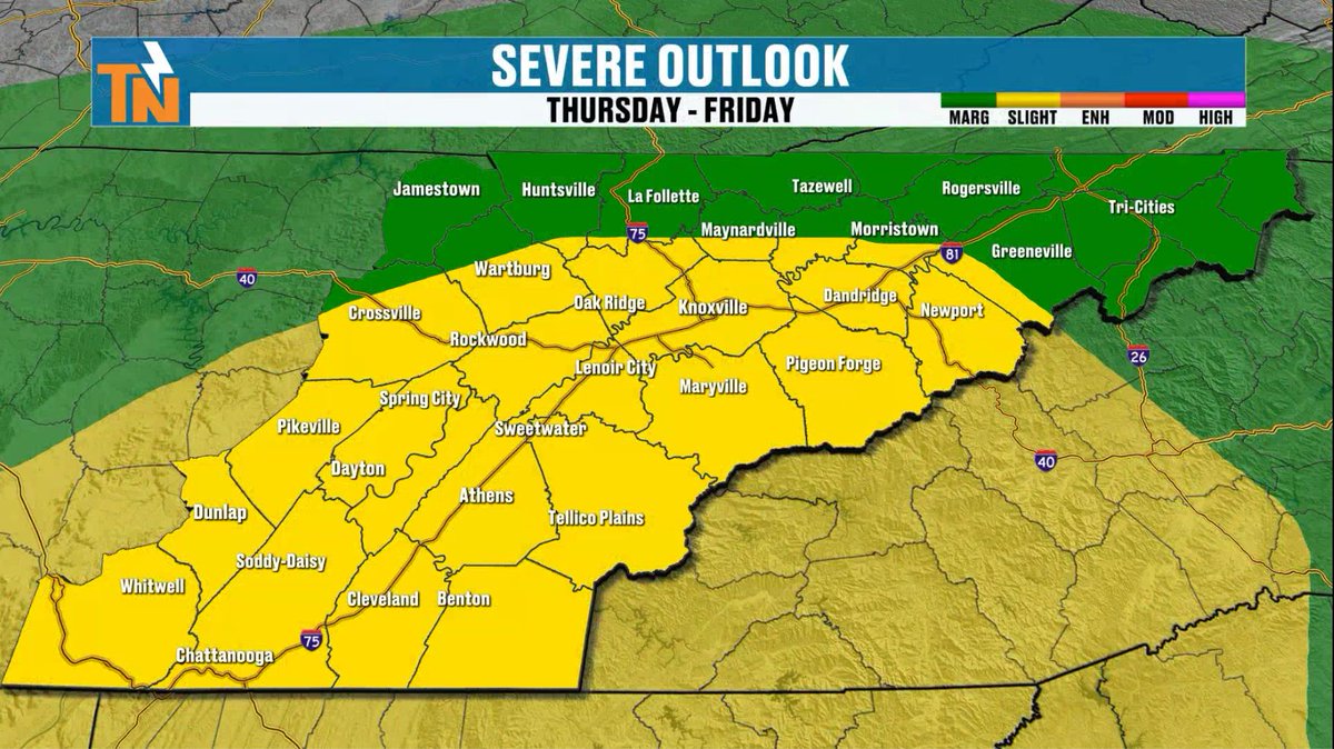
Oh... and storms could become strong to severe if they fire off as the Storm Prediction Center has put un in a level 1 & 2 risk for isolated severe storms.
There is a lot of energy in the atomosphere.
@PipeWrenchPHC
@pipewrenchplumbinghvac has been in business since 2001, They have proudly delivered top-notch plumbing and HVAC services to the greater Knoxville community. Whether you need repairs, replacements, or maintenance, we offer same-day service to quickly address all of your plumbing, heating or cooling needs. You can trust the experts at Pipe Wrench for reliable, long-term solutions to any problem that arises. And remember, Same Day Service Guaranteed, or your visit is FREE!
I arrive with fireworks in the sky, flags in the breeze, and
celebrations far and wide. This year I carry a special birthday-250 years in the making.
What month am I?
❤️ Answer: July! 🇺🇸🍉
#WelcomeJuly#America250
The heat is turning dangerous across East Tennessee.
A prolonged stretch of excessive heat and high humidity has prompted Heat Advisories through Thursday, with heat index values pushing 100° to 105° in many spots.
But the heat isn’t the only concern...
Each afternoon, scattered storms will develop bringing:
⚡ Strong wind gusts
🌧️ Heavy downpours
🌊 Localized flooding
⛈️ Frequent lightning
In this forecast, I break down:
• The hottest days ahead
• When storms are most likely
• Who has the best chance for heavy rain
• How long this heat wave lasts
This is classic midsummer weather in East Tennessee — hot, humid, and stormy.
📲 Download the eastTNweather app for alerts, radar, and the latest forecast anytime.
#EastTNWeather #HeatAdvisory #KnoxvilleWeather #SummerHeat #EastTennessee
This forecast is sponsored by: @dollypartonchildrenshospital
🔥 THE DANGEROUS COMBO 🔥
Extreme Heat & Oppressive Humidity Are Moving In.
It’s not just the temperature—it’s the humidity. Over the next several days, we are tracking a brutal combination of high temperatures and extreme dew points that will make the air feel downright dangerous.
💦 The Moisture Factor (Dew Points)
Dew points are going to be locked in the mid-to-upper 70s for much of the week, peaking at a tropical 77°F. When dew points are this high, the air is saturated with moisture, meaning your body cannot efficiently evaporate sweat to cool itself down.
📈 The Heat Index (What it Feels Like)
Because of that heavy moisture, our Heat Index Trend is absolutely skyrocketing well past our local Heat Advisory criteria (105°F):
Monday: 104°F
Tuesday: 105°F 🚨 Peak Heat Day
Wednesday & Thursday: 105°F
Friday & Saturday: 104°F – 107°F
We will be flirting with or shattering Heat Advisory thresholds for six straight days. This kind of prolonged, multi-day extreme heat places an immense amount of cumulative stress on the human body.
⚠️ CRITICAL HEAT SAFETY REMINDERS:
Limit Outdoor Exposure: Avoid strenuous activities, yard work, or outdoor workouts during peak heating hours (11:00 AM – 5:00 PM).
Hydrate & Replace Electrolytes: Sip water constantly throughout the day. If you have to be outside, incorporate sports drinks to replace lost salts.
Seek AC & Shade: Fans won't cut it when the heat index is near 110°F. Spend time in air-conditioned spaces to give your body a break.
Check on Vulnerable Neighbors: Ensure the elderly, kids, and pets have a reliable, cool place to stay.
Take this week seriously, stay ahead of the heat, and keep your cooling plans ready!
#TNwx #HeatAdvisory #HeatIndex #SummerHeat #WeatherSafety #StayCool
At @burks&ogle we’ve built a reputation for delivering strong outcomes. Our attorneys combine experience, focus, and a personal approach to every case we take.
We make sure you understand your options from the start. Then we help you build a clear, proactive strategy designed to win.
🌡️ HEADS UP! A major heat wave is building. 🌡️
Ever wonder why it gets so hot for so long? This "heat dome" isn't random—it's caused by a strong ridge of high pressure.
Check out our breakdown of how it works:
1️⃣ Sinking Air: High pressure squeezes and heats the air.
2️⃣ Blocked Jet Stream: Cool air is forced far to the north.
3️⃣ Trapped Heat: Intense sunshine bakes the ground with no cloud cover.
4️⃣ The Build-up: Every day gets hotter than the last.
SAFETY TIPS
💧 Hydration & Nutrition
Drink Before You're Thirsty: Don't wait until you feel parched. Sip water steadily throughout the day.
Electrolytes Matter: If you are sweating heavily, replace lost minerals with a sports drink or a light snack.
Limit Dehydrating Drinks: Cut back on alcohol, highly sugary drinks, and heavy caffeine, as they can cause you to lose more body fluid.
🏠 Staying Cool Indoors
Seek AC: If your home doesn't have air conditioning, spend the hottest hours of the day at public locations like libraries, shopping malls, or community cooling centers.
Fan Limits: Electric fans can provide comfort, but once temperatures reach the high 90s, blowing air won't prevent heat illness. Focus on taking cool showers or moving to an air-conditioned space.
Block the Sun: Keep window shades, blinds, or curtains closed during the day to reflect unwanted solar heat away from your living space.
☀️ Outdoor Precautions
Shift Your Schedule: Avoid strenuous outdoor activities or workouts during peak heating hours (typically 10:00 AM to 4:00 PM). Shift tasks to early morning or late evening.
Dress Light: Wear loose-fitting, lightweight, and light-colored clothing to help reflect heat and allow your skin to breathe.
Never Leave Anyone in a Car: Temperatures inside a parked car can climb to lethal levels in a matter of minutes. Always "Look Before You Lock" for children and pets.
⚠️ Know the Warning Signs
Heat Exhaustion (Act Fast): Heavy sweating, dizziness, weakness, nausea, or a headache. Action: Move to a cool place, sip water, and loosen clothing.
Heat Stroke (Emergency): High body temperature (above 103°F), hot/red/dry or damp skin, fast pulse, confusion, or fainting. Action: Call 911 immediately and cool the person down right away.
🔥 The summer heat is about to crank up across East Tennessee 😰
A strong ridge of high pressure is building in, and that means the atmosphere is going to lock in the heat and humidity for much of next week. Highs will push into the low to mid 90s, but the heat index could climb near 105° at times.
☀️ Lots of sunshine
🥵 Dangerous heat
💧 Tropical humidity
⚠️ Heat stress will become a concern if you’re spending time outside
This is classic summertime ridge-rider weather… hot, sticky, and not much relief.
Now’s the time to prepare:
✔️ Stay hydrated
✔️ Limit outdoor activity during peak heat
✔️ Check on kids, pets, and the elderly
From tough trucks to family SUVs, YOU pay what WE pay on new Ford vehicles at @rayvarnerford in Clinton
American value for American values.
This is what's heading our way!
Remember, we are under a level 1 & 2 risk for potential severe storms. Damaging wind is the main threat with large hail possible.
@volunteerhomemortgage
Mortgages can feel overwhelming. From changing your home to changing your hometown, so much comes along with everything you need for a home mortgage.