Geospatial Data and Development Services firm
Building Mobile GIS Mapping Apps
Web Mapping Applications
Desktop GIS Applications
Consulting, Support, Data Serv
@giswqs Great work 👏. Lots of compromises with your architecture trying to satisfy all platforms. If you are using rust then use rust and leverage that for data handling and serving instead of browser and wasm. If targeting s3 static hosting then offer wasm.
@giswqs@berttemme Did you finally take advantage of rust and start serving data and ma managing data in RUST. replace duckdb wasm with regular duckdb for desktop app?
new AI powered form designer (also builds forms based on ESRI FeatureServer, GPKG, other data) https://t.co/E37mrHPXFN creates XLSForms for ESRI Survey123 and ODK apps and JSON Form Designs for Tech Maven Geospatial iOS, Android, Windows and Web Apps. We are sell this for self hosting for one-time payment of $499. Link to purchase will be added soon.
@spatialillusion You also don't know format png what encoding (mapzen terrarium, mapbox terrian-rgb, gdal gridded coverage, maptiler dem, other heightmap)
https://t.co/XUiNtxsRxv Powerline PLS-CADD Conversion to ESRI UN - Utility Network or PostGIS Database. With support for CDC Change Data Capture and Data Conflation
GeoLake Gateway - geospatial data serving from S3 Bucket hosted cloud native/optimized data as ESRI equivalent mapping services without the ESRI ArcGIS Enterprise licensing. https://t.co/WtDTbpjB33
Add Video Feeds from UAS/Drones and Helicopters and Aircraft to QGIS Desktop and ArcGIS Pro (without image analyst) and perform AI powered analysis. Display platform and sensor and field of view on the map and be able to extract geospatial data from video https://t.co/VQnHLPrrYw
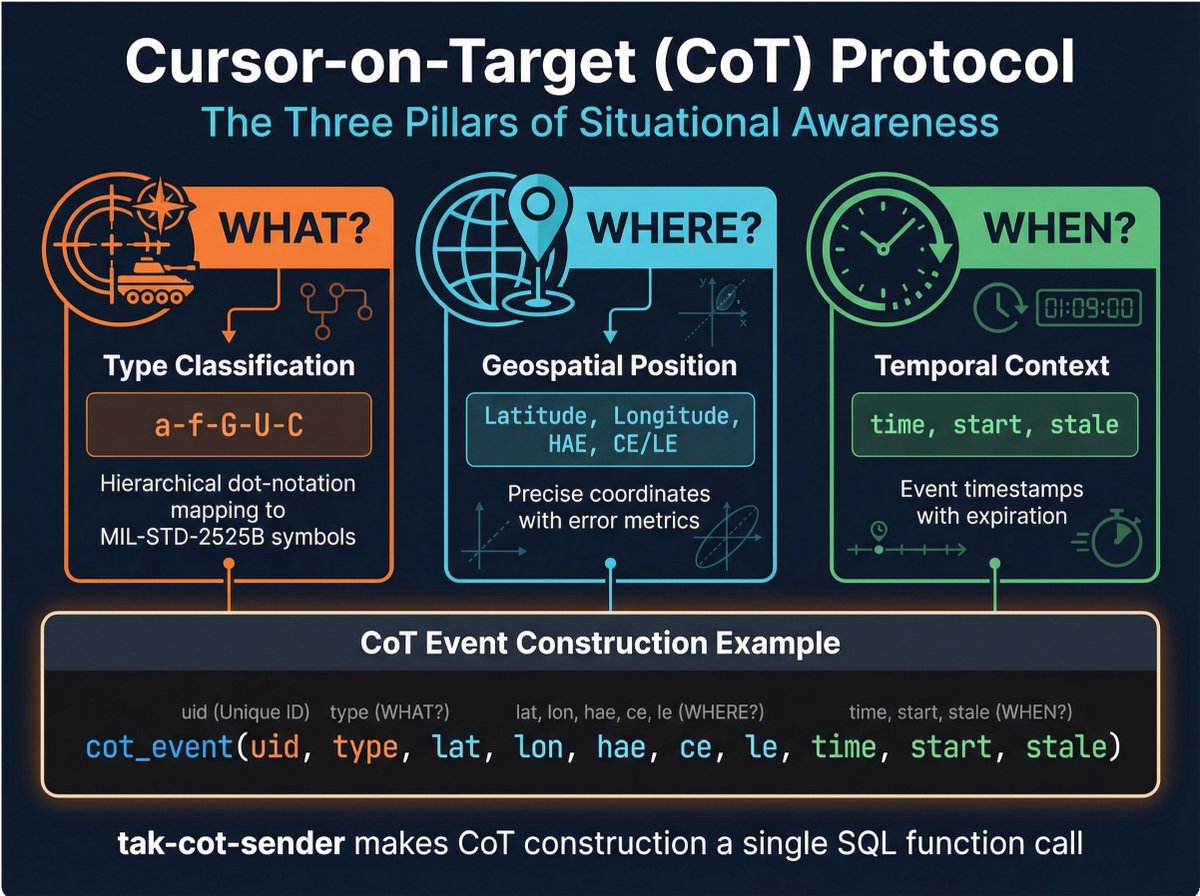
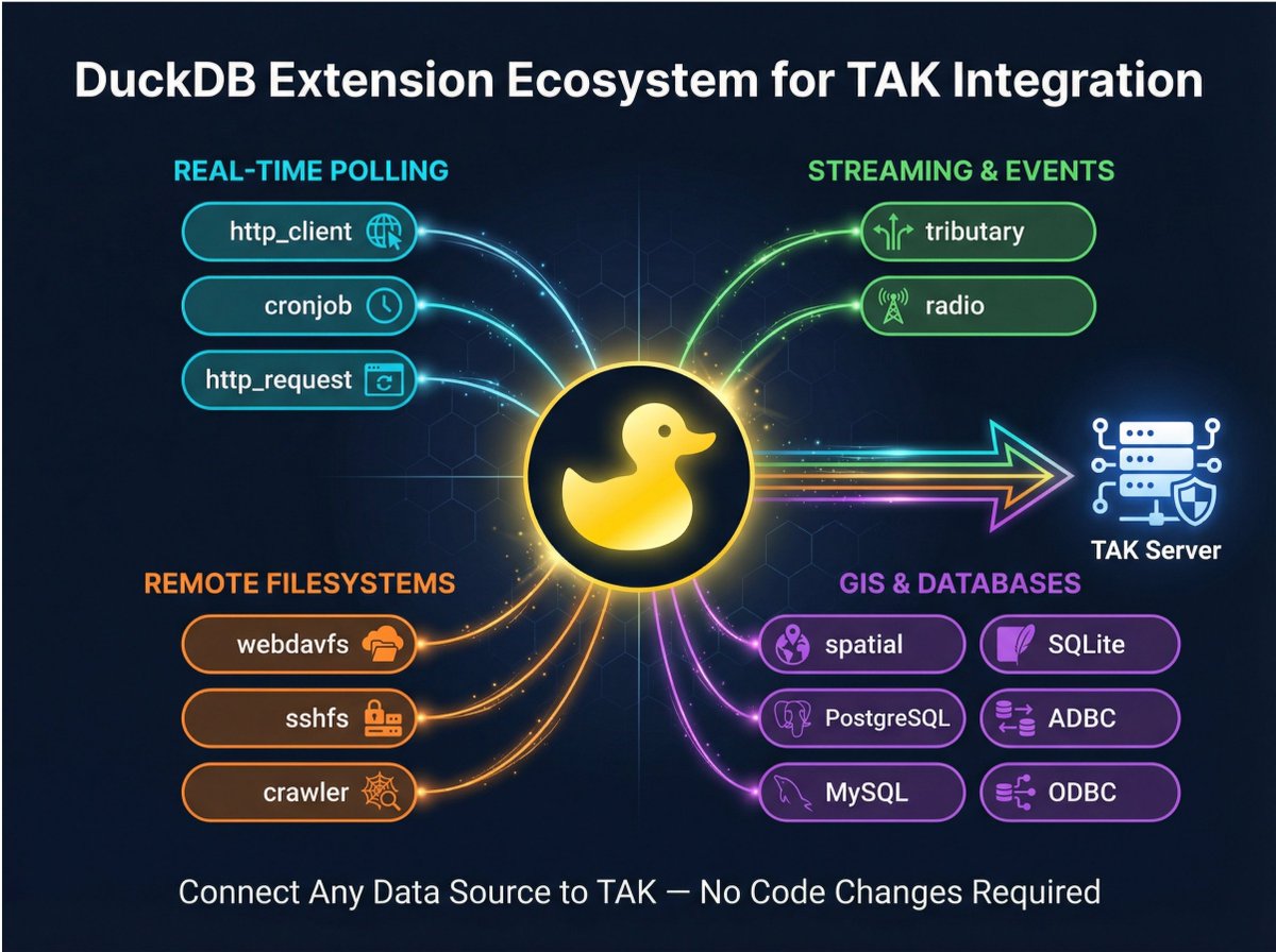
https://t.co/y23B6hriKi We've developed a powerful flexible solution that is a TAK Gateway as a Duckdb Extension (supporting bi-directional data to/from TAK Server) Support ATAK, iTAK, WinTAK, WebTAK and Other TAK Clients. This means you can use duckdb to pass through any supported data by any of the duckdb native features and extensions.
GeoLake Gateway - store your geospatial data in a S3 bucket (data lake) and offer ESRI equivalent mapping services with full compatibility with apps (ImageServer and MapServer from COG GeoTIFF, SceneServer from COPC LiDAR LAZ 1.4, FeatureServer and VectorTileServer from any GIS Vector Format, StreamServer from movement/event-driven data feeds)
handle massive petabyte scale geospatial data hosting in https://t.co/BM4jielzcX ( no affiliation with them) and offer both cloud native optimized http URL's and modern mapping services https://t.co/ISIIqlgWXC Upload your UAS/Drone Data and big orthophoto-imagery and LiDAR Point Cloud Collection and efficiently serve it and have integrated viewer and spatial analysis. Including 3D Geospatial Digital Twin data (i3S SceneServer and 3DTILES, Gaussian Splats, GLB 3D Models)
handle massive petabyte scale geospatial data hosting in https://t.co/U3pm9qoEnW ( no affiliation with them) and offer both cloud native optimized http URL's and modern mapping services https://t.co/JADz5YM3iN
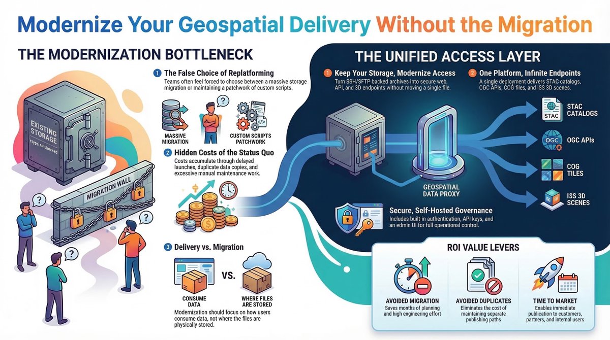
https://t.co/QB2ytUgHCK looking to store petabytes of geospatial data efficiently we've developed a solution that uses https://t.co/Ve5inPbxIs and offers proxy (range request headers http URL) and OGC API Features, OGC API Tiles and cached map tiles (XYZ/WMTS) and COG Tile Server as XYZ and WMTS with full STAC Spatial Temporal Asset Catalog. We are selling this as one-time payment of $2,500. Comes with an advanced maplibre gl js map viewer with full cloud native file format support and a no code form builder.
We've developed a super advanced MapLibre GL JS Geospatial Viewer/Editor that fully works inside the ESRI ArcGIS Enterprise or AGOL space. Can interact with ESRI Services and perform edits and analysis, consume all the ESRI services and configure the map with WebMapId or WebSceneID or CatalogLayerJSON Config. It supports all the cloud native/cloud optimized file formats. It has duckdb web assembly for client-side analysis https://t.co/jALItX35KS
We've updated some of our apps to create and serve AVIF Raster Images which are much more lightweight than JPG or WebP images. All modern browsers support this format so there is no change for web apps.
We can serve MBTILES and PMTILES raster tiles with AVIF imagery with the correct encoding/headers as well as convert PNG or JPG to AVIF with Tile Utilities. For mobile your best bet is WebP since AVIF adds too much overhead on mobile mapping apps to decode and will drain battery. https://t.co/v1I4iyyaoa https://t.co/9Abw3gkqc4 https://t.co/yPc7rIg2hJ
Geospatial AI revolution for Airport Operations - spatial real-time intelligence platform https://t.co/k5ngfaXbIs Fusion of GIS, CAD, BIM, iOT Sensor Data, Enterprise Systems into one platform for rapid insights, analytics, analysis, visualization, SA, COP, C2
GeospatialCloudServ https://t.co/5hqmqdGmcO a true 3D/4D Intelligence Platform (self-hosted) ready for your advanced digital twin visualizations and analysis