⚠️⛈️Severe Thunderstorm Warning for DAMAGING WINDS and HEAVY RAINFALL
Severe thunderstorms developing about the southern and central interior and southeast as a trough deepens and moves east today
https://t.co/GvTgIPWiA5
NEWS: ECR announces Alexander Rossi underwent successful outpatient procedures to repair minor injuries to his left hand and right ankle sustained in today’s practice incident at @IMS.
The No. 20 driver remains under evaluation with the intent to compete in Friday's Carb Day practice and Sunday's Indianapolis 500.
#BREAKING: US President Donald Trump says an attack on Iran that was "scheduled for tomorrow" has been postponed at the request of gulf state leaders. https://t.co/GKXz1YPXXA
The INDYCAR community mourns the passing of Alex Zanardi.
A two-time series champion, 15-time race winner and one of the sport’s most inspiring figures, his legacy on track was matched only by the strength of his character.
⚠️⛈️Severe Thunderstorm Warning for HEAVY RAINFALL
parts of north Queensland
Slow moving thunderstorms producing heavy rainfall over western North Tropical Coast and southern peninsula area.
#Georgetown#Forsayth#MountGarnet#Chillagoe#Einasleigh
https://t.co/GvTgIPWiA5
⛈️Queensland Thunderstorm Outlook - 7 January
Storms possible about the north of the state tomorrow
Severe storms with heavy rainfall about the are possible about eastern Cape York between Cooktown and Lockhart River
https://t.co/4B5ukOXCcR
⛈️Queensland Thunderstorm Outlook - 8 January
Storms possible about the north of the state tomorrow
Severe storms with heavy rainfall about the are possible about parts of eastern #CapeYork, #NorthTropicalCoast&Tablelands
https://t.co/4B5ukOXCcR
⛈️Thunderstorm Forecast, Thurs 1 Jan
🟠Severe thunderstorms are possible about parts of the #NorthernTablelands, #NorthernRivers and #MidNorthCoast this afternoon and evening.
Hazards: heavy rain leading to flash flooding, possibly damaging wind gusts and large hail.
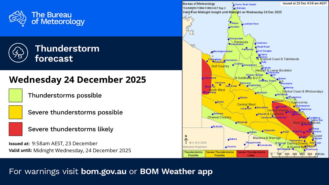
⛈️Thunderstorm forecast for today (24/12):
🟢Non-severe thunderstorms possible across #Queensland.
🟡Severe thunderstorms possible across most of the state.
🔴Severe likely far northwest, and #Clermont to #Toowoomba.
Main risk: heavy to intense rainfall.
https://t.co/4B5ukOXCcR
⚠️⛈️Severe Thunderstorm Warning - Southeast Queensland for HEAVY RAINFALL and LARGE HAILSTONES
parts of Gympie, Somerset, Noosa and Moreton Bay Council Areas.
Slow moving severe storms with heavy rainfall are approaching Gympie and Pomona.
https://t.co/jHQ56gIqFh
⛈️Queensland Thunderstorm Forecast - 24 Dec
🟥Severe storms with heavy rain are likely in the far northwest and between Clermont and the Sunshine Coast
🟨Severe storms with heavy rain possible from NW to SEQld.
🟩Non-severe thunderstorms elsewhere
https://t.co/4B5ukOXCcR
⚠️⛈️Severe Thunderstorm Warning - Southeast Queensland for HEAVY RAINFALL
parts of Toowoomba and Western Downs Council Areas.
Severe thunderstorm complexes producing heavy rainfall over Toowoomba, Lockyer Valley and Southern Downs this morning.
https://t.co/jHQ56gIqFh
Tomorrow, areas of rain with heavy falls possible in the far northwest and Gulf Country. Severe thunderstorms with heavy rainfall broadly possible in band from western to central and southeastern Queensland.
More: https://t.co/QYRYz5cIXN
⚠️⛈️Severe Thunderstorm Warning for HEAVY RAINFALL
Severe thunderstorms continuing over southeast Queensland this morning.
Locations which may be affected include #Toowoomba, #Gatton, #Boonah, #Laidley, #Oakey and #Lowood .
https://t.co/GvTgIPWiA5
⚠️⛈️Severe Thunderstorm Warning - Southeast Queensland for HEAVY RAINFALL
parts of Toowoomba and Western Downs Council Areas.
Severe thunderstorm South of Dalby with heavy rainfall moving towards Toowoomba this morning.
https://t.co/jHQ56gIqFh