Man. #Hurricane#MELISSA. Incredible power. Perhaps the mightiest hurricane of the 83 I've witnessed.
My location (Crawford, a tiny beach town in St. Elizabeth Parish #Jamaica) took the full force of the inner right eyewall and may have seen the peak winds in this historic, record-smashing hurricane.
First pic: as it started to get scary. Bone-rattling gusts were making roofs explode into clouds of lethal confetti. The grand palm tree out front was starting to bend obscenely—in a way I found unnatural.
Second pic: after we bolted the door shut because it was getting too dangerous even to watch the storm. (I'd randomly ended up in the hotel's kitchen with a local family.)
The hurricane's inner eyewall was a screaming white void. All I could see through the cracks in the shutters was the color white—accompanied by a constant, ear-splitting scream that actually caused pain. (Notice the woman in the pic holding her ears.) The scream occasionally got higher and angrier, and those extra-screechy screams made my eardrums pulse. Meanwhile, water was forcing in through every crack—under the floor and between the window slats.
I remember shuddering at the thought of what was happening to the town—what this screaming white void was doing to people, homes, communities.
My fears were well-founded. The impact in this part of coastal St. Elizabeth Parish is catastrophic. Wooden structures were completely mowed down and in some cases swept from their foundations. Some concrete structures collapsed. The well-built ones—like my hotel—survived, but even they had major roof, window, and door damage. The landscape has been stripped bare—the trees just sticks. The roads are blocked with rubble and utility poles.
Nearby Black River—a unique old historical town right on the water—was smashed beyond recognition: historical sites destroyed, main streets filled with rubble, the town market twisted like a pretzel, even the regional hospital destroyed.
It's a good thing I wasn't in my hotel room during the storm because one of the windows blew out, showering the bed with glass and wood. The hotel lost most of its roof, and several third-story rooms were smashed open. But in the lower flooors, those grand old concrete walls protected us. And so far I'm aware of only two deaths in Crawford—a fellow who had a heart attack at the school next door (his body was still in his car and unclaimed the next morning, a sad and disturbing sight), and a woman who drowned in the storm surge in Gallon Beach. While walking down the devastated streets of Black River, I ran into the Jamaican Member of Parliament for this region, @floydgreenja. He's a great dude and I appreciate that he already has a gameplan for turning this catastrophe into an opportunity—to build this region back better. And I vowed on the spot that I'm going to make it my mission to spread awareness of this catastrophe and get that aid flowing in. I'll be talking about MELISSA a lot over the coming months—because it is both a fascinating meteorological event and a human disaster that demands an international response. (And I swear an epic video is coming out of this.)
Small taste of #Hurricane#MELISSA on SW coast of #Jamaica, just as we started getting raked by violent right eyewall. Belive it or not, this was before the peak conditions, when everything turned white, the screaming sound became unbearable, & we needed to bolt the door shut.
8 AM ~ Invest #95L sigue con una probabilidad de formación ciclónica de 50/70% para los próximos 2/7 días.
Una depresión tropical es probable que se forme a mediados de la semana. Intereses en las Islas de Sotavento deben monitorear el progreso de este sistema. #Huracanes2025
Onda tropical se acercará al NE del Caribe entre hoy y mañana, aumentando los aguaceros y tronadas en PR hoy lunes, con períodos de lluvia fuerte hoy. La probabilidad de inundaciones será de LIMITADO a ELEVADO, sobre todo en el interior, sur y suroeste. ¡No cruce zonas inundadas!
🍂 Hoy a las 2:19 PM AST, comienza oficialmente el Otoño en Puerto Rico y las Islas Vírgenes Estadounidenses.
¡Feliz primer día de otoño! 🌅🌴✨
🍂 Fall Begins Today 🍂
Today at 2:19 PM AST, Fall officially begins in Puerto Rico and the USVI.
Happy first day of Fall! 🌅🌴✨
ESTAMOS EN EL MES PICO DE LA TEMPORADA DE HURACANES ▶️ En septiembre, la formación de ciclones tropicales favorece el Atlántico tropical hacia el oeste a través del Caribe y el Golfo, y hacia el noroeste hacia el oeste y centro del Atlántico. 🌀
El agotamiento por calor puede provocar un golpe de calor (insolación). Si experimenta mareos, sed, sudoración, náuseas o debilidad, vaya a un lugar más fresco, póngase ropa cómoda y ligera, y busque atención médica si los síntomas no mejoran. ¡Reaccione rápido!
HURRICANE ANDREW 33 YEARS AGO 🌀 On this day in 1992 the Category 5 struck South Florida with 165 mph winds. In total, Andrew destroyed more than 63,500 houses, damaged more than 124,000 others, caused $27.3 billion in damage and left 65 people dead. What do you remember about the storm?
Hay COMUNICADO ESPECIAL SOBRE LAS CONDICIONES DEL TIEMPO hasta las 1:15 PM para Moca y San Sebastián. Tronada fuerte se mueve sobre San Sebastián a esta hora. La misma está produciendo fuertes aguaceros, rayos frecuentes y vientos en ráfagas de hasya 40 mph. 🚨⚠️⛈️
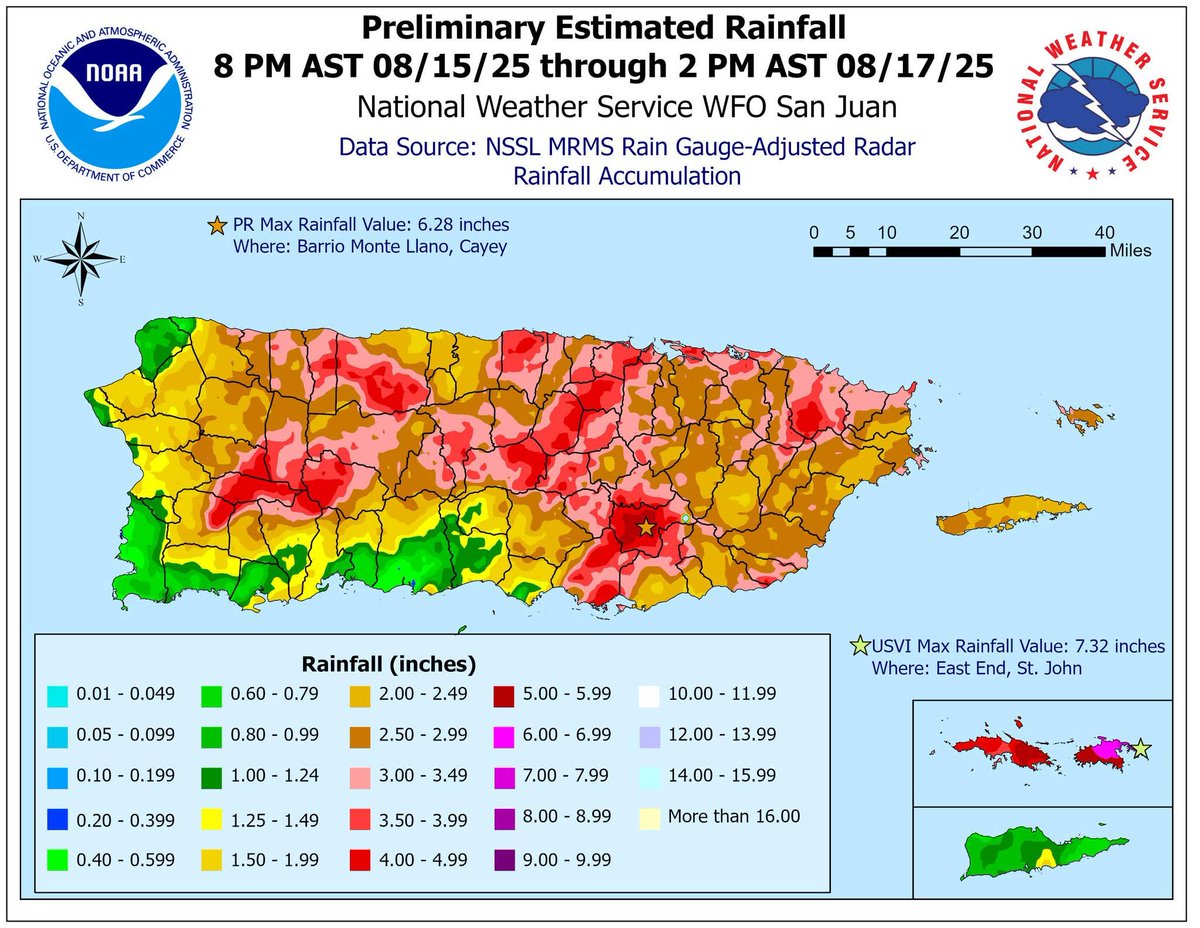
Aquí las cantidades de lluvias preliminares tras el paso cercano por nuestra zona del huracán #Erin. En Cayey ya han caído 6.28". Lluvias adicionales podrían caer en las próximas horas debido a humedad tropical asociada a Erin. 🌀 #Huracanes2025