@raisingcanes when is the grand opening of your #AvonCT location. You keep teasing me as someone who's been having #OneLove since the early days of #BatonRouge. I'm ready for the magic.
Tomorrow, is Easter. (it just happens to fall on 3/31 this year)
Tomorrow is also International Transgender Day of Visibility. (It's on 3/31, every year)
Tomorrow (3/31) is also:
National Crayon Day
Hug a Medievalist Day
Cesar Chavez Day
Dance Marathon Day
Eiffel Tower Day
National Baked Ham with Pineapple Day
National Farm Workers Day
National Tater Day
Our @COWYRedCross volunteers are responding at the request of @cityoflongmont@LongmontPS to support those families affected by a apartment fire. Our teams will be working with these clients to aid them in their recovery.
🌎 Help change the world by working for the #RedCross. We are hiring a Disaster Program Manager in Western CT. In this role, you will manage a volunteer team and support communities recovering from local disasters such as home fires. Learn more and apply: https://t.co/C2Pb6q75wu
Colorado averages about 300 days of sunshine every year! #COwx
But today is not one of those days.
It also wasn't yesterday.
Or the day before that.
Or the day before that.
Or the day before that....
Good mernin!
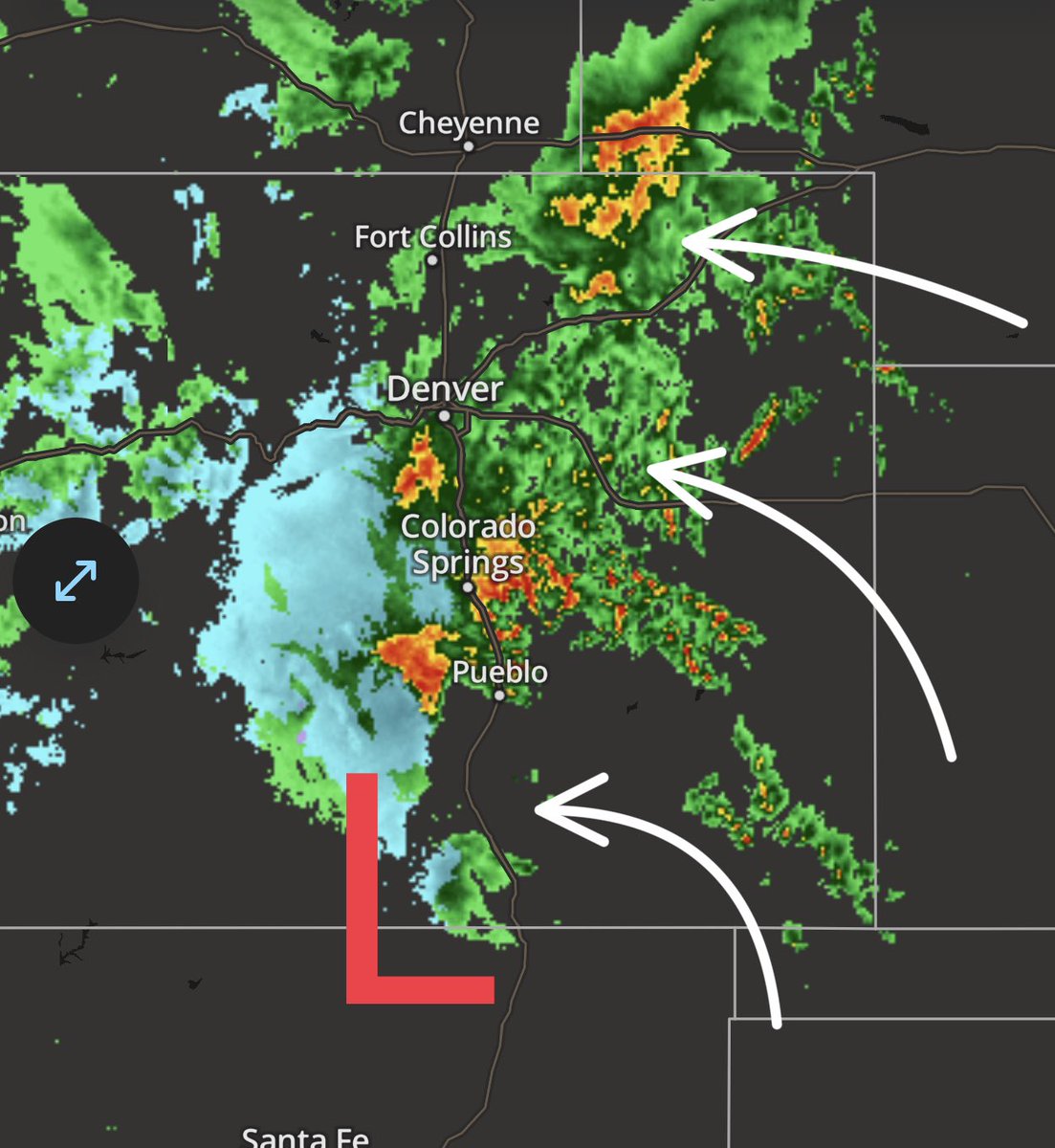
A FLOOD WATCH encompasses all of northern Colorado along and north of the Palmer Divide including Denver, southeast Wyoming, western Kansas and Nebraska panhandle.
Our powerful storm system is currently centered over south central Colorado.
“Feeder bands” of rain and embedded thunderstorms continue to move across the eastern plains towards the front range and the higher elevations of the foothills and continental divide as indicated by the white arrows.
In fact, several reports of hail this morning out of El Paso County around Colorado Springs as well as some flooding going on near the Fountain & Security Widefield areas.
The center of low pressure will SLOWLY move east across southern Colorado today and then drift northeast getting to near Burlington by around 8pm tonight and near McCook, Nebraska by NOON on Friday. The flow around the circulation will continue to feed moisture into the region so numerous rounds of rain showers and thunderstorms are expected today and into Friday.
Some of these thunderstorms will be strong producing heavy rain, gusty winds, and small hail.
I cannot rule out one or two storms being severe today with large hail being the main threat and of course there is a conditional threat of a brief tornado.
There is an elevated threat of severe weather this afternoon on the eastern plains and in western Kansas closer to the periphery of the center of low pressure where thundertorms will likely erupt along and south of the I-70 corridor here just before NOON.
Meanwhile heavy wet snur is falling in the higher elevations of the foothills, central mountains, and Sangre de Cristos. Expect snow to get locally heavy for the northern mountains where up to 18” could fall above 10,000 feet!
Stay tuned for updates throughout the day!
Thank you to all of you who have donated to my coffee and wine fund so far. It’s appreciated more than you’ll understand!
Also thank you for supporting my local business so sponsors who are working overtime to make sure all of my followers are getting the help they need.
K great thanks bye #COwx #WYwx #NEwx #KSwx #Rain #Snow #SevereWx
🚨Do you have a working smoke alarm? If not, SOUND THE ALARM & the Red Cross can help!🚨 The Red Cross, in partnership with local fire departments, installs free smoke alarms as part of our Sound the Alarm events. Partners in video: @FireSafeSC & the Pacolet Fire Department🔥🚒
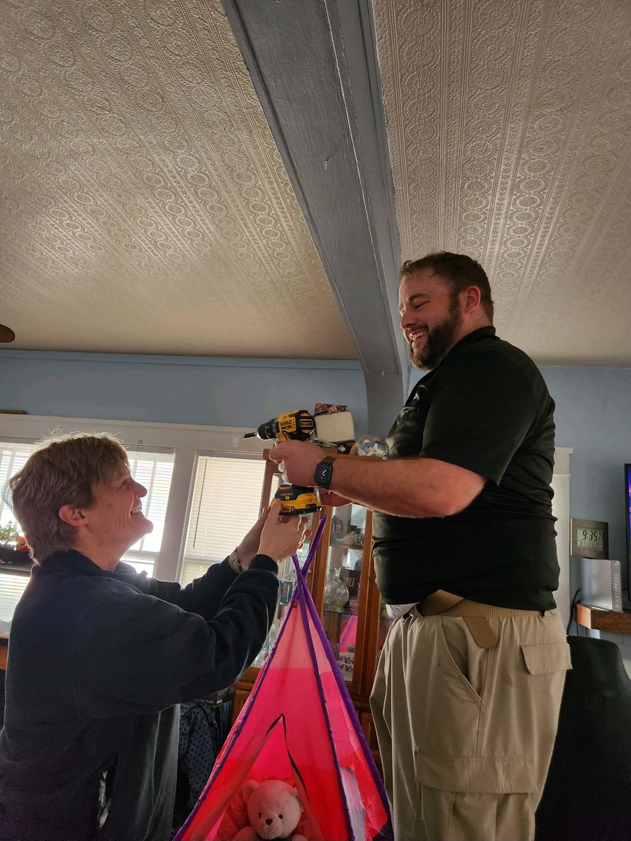
Pueblo Fire and the Red Cross canvasing parts of the East side today to make homes safer. The mayor stopped by to express his appreciation. Thank you Red Cross volunteers!!! @CityofPueblo@COWYRedCross