@TheRealAGon@AshleyDean No need to cringe about Limon. It was not named for the Spanish word with the same spelling. It was named for a guy who worked on the railroad when it was built through there: https://t.co/O3vJuzdx5t
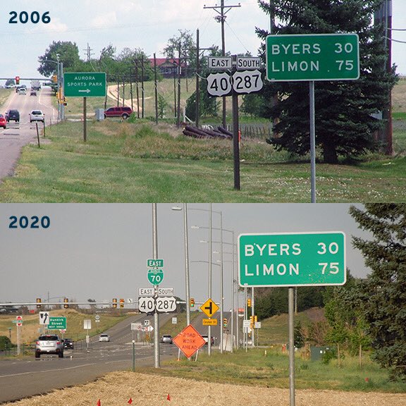
... But today Denver's outer loop is three miles farther ahead, and Aurora has annexed land another 15 miles ahead. So this mileage sign, while still accurate, has become an anachronism, because now most drivers at this location do NOT have a destination outside the metro area.
Suburban development leapfrogged this mileage sign decades ago. Signs like this are intended to be posted where the road leaves behind the developed part of a town and resumes highway speed. This one (dated 1998) has probably been replaced in-kind for the past several decades..
Shortly after Alaska became a state, they sought permission to sign their segment of the Alaska Highway as a northern extension of US 97. AASHO approved, but only on the condition that Yukon also signed their segment with the number 97, which they have not done.
Last year the west terminus of US 175 was relocated. Its old route (SM Wright Fwy) will eventually be torn up, but as of now parts of it are still open. It's eerily quiet, but it is still posted with US 175 signs. The VMS shown here referred to it as "I-175".
Not many US routes are tolled; which others can you think of? This is the north beginning of US 301, the longest 3-digit US route in the East --> https://t.co/18dFmXfIZb [p/c AARoads]
Lots of delicious 1940 cutout goodness here! This was in front of the old Orpheum Theater (today's Five Flags), looking west on 4th. At the next intersection (Locust) was the north beginning of US 67 --> https://t.co/TxFUClLvdY
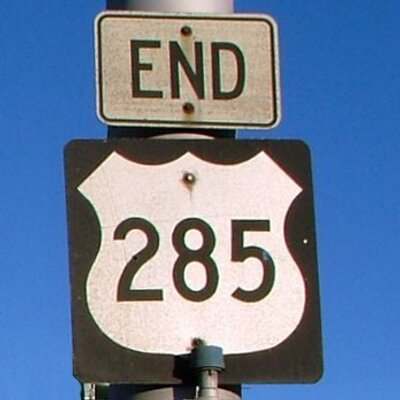
This endpoint was established in the 1950s. But for a brief time during the '30s, this was the terminus of a different US route. Guess which one? Cheat sheet --> https://t.co/atX3Tbv8Qf [p/c Paul Dienhart]
Looking south at the east terminus of US 26. A nearly identical sign is posted just ahead (over the Platte River bridge) at the westbound on-ramp for I-80; see it here --> https://t.co/oVvAblZ8Xr
AASHO had its own plan for eliminating the split routes by replacing one of them with a new US 37 designation. But they couldn't get IN and KY to agree on the details, so US 37 was never signposted, and the US 31 split routes still exist--> https://t.co/VPftqksDj1
This 1934 photo was taken by a representative of Indiana DOT to illustrate the confusion caused by directionally-suffixed US routes. Traffic at this point was heading EAST on Broadway, which was also NORTH-bound on a highway designated 31 WEST!
...or why Kentuckians would allow these signs to be posted in their state). INDOT was petitioning AASHO to force KYDOT to instead signpost the split routes as US 31 and Alternate US 31.
The highest segment of the highest US route, well above timberline: US 34 (aka Trail Ridge Road) through Rocky Mtn. Nat'l. Park. This view is northwest from Iceberg Pass; the switchbacks are known as Tundra Curves. Also visible is the pullout for the Lava Cliffs overlook.
Just up from there, the road disappears behind a ridge, where it reaches maximum elevation of 12,183 feet before dropping down slightly to the Gore Range overlook and the Alpine visitor center. This segment of US 34 is open only about five months out of the year.


![usends's tweet photo. A long way from Jacksonville FL, over 1400 miles. More photos from both endpoints --> https://t.co/CgseA6n58j [p/c Paul Dienhart] https://t.co/qbmm645KNw](https://pbs.twimg.com/media/EyI4vvLWQAceMHK.jpg)


![usends's tweet photo. Not many US routes are tolled; which others can you think of? This is the north beginning of US 301, the longest 3-digit US route in the East --> https://t.co/18dFmXfIZb [p/c AARoads] https://t.co/6xgiEMJb4z](https://pbs.twimg.com/media/EvhiweOVkAgEnIg.jpg)

![usends's tweet photo. This endpoint was established in the 1950s. But for a brief time during the '30s, this was the terminus of a different US route. Guess which one? Cheat sheet --> https://t.co/atX3Tbv8Qf [p/c Paul Dienhart] https://t.co/JHZdFZdIPF](https://pbs.twimg.com/media/EuMQFwSUUAwcotU.jpg)


