A Special Avalanche Advisory continues for the mountains of Utah and SE Idaho, as record warm temperatures increase the likelihood of destructive wet snow avalanches. Avoid travel on and beneath steep slopes.
Visit https://t.co/xRuSiGCnQf for the full forecast and information.
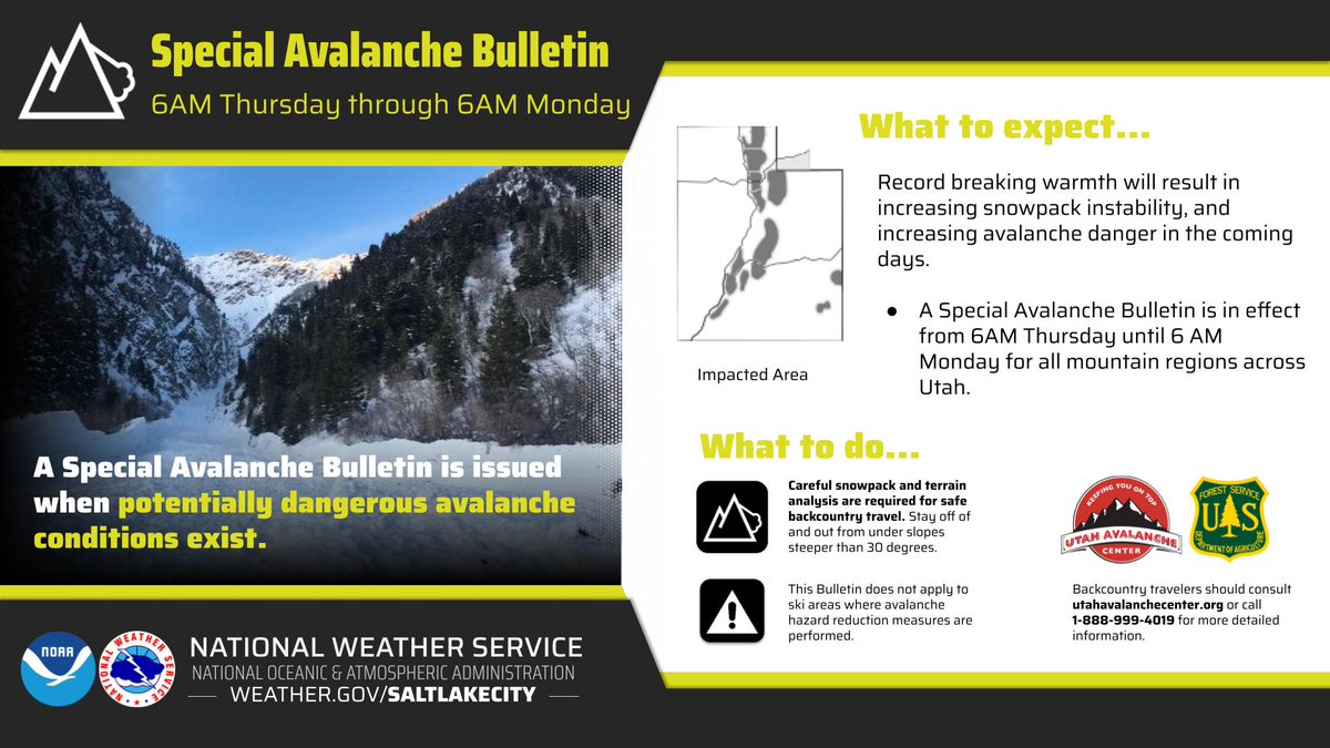
Record-breaking warm temperatures will destabilize the snowpack across the state, increasing the avalanche danger. Wet avalanches could occur on all aspects and at all elevations. Avoid travel on and below steep slopes, including avalanche runout zones and terrain traps.
Given the record breaking warmth, avalanche danger is expected to increase in the coming days. From @utavy_, Special Avalanche Bulletin has been issued from 6 AM Thursday to 6 AM Monday for all Utah mountains. Be sure to check https://t.co/7cuDMe9ejo for more information! #utwx
Heavy snowfall and strong winds are increasing avalanche danger across the mountains of Northern, Central, and SW Utah, as well as SE Idaho. The UAC has issued an AVALANCHE WATCH for dangerous avalanche conditions https://t.co/F7U6mPqKX9
MODERATE avalanche danger exists on all upper and mid elevation slopes where you’re likely to trigger wind slabs. As the day warms, expect the potential for wet loose slides to rise. For more info, check the forecast: https://t.co/F7U6mPqKX9
Saturday January 10th, 2026: MODERATE avalanche danger exists on all upper and mid-elevation slopes where you’re likely to trigger sluffs (loose dry avalanches) and sensitive soft slabs of wind blown snow. A PWL still exists on W-N-E upper and mid elevs https://t.co/F7U6mPqKX9
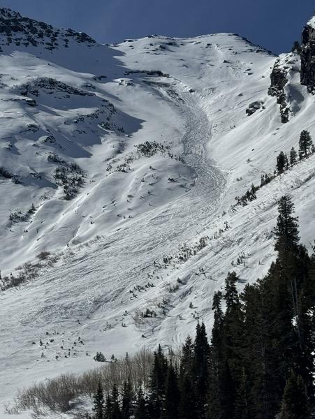
Sunday January 4th, 2026: The avalanche danger is MODERATE at upper and on W-N-SE facing slopes at mid-elevations above 9500’ where the wind continues to drift new snow into slabs 1-3’ deep. Deeper, destructive slides on a PWL are possible in steep, rocky, northerly slopes.
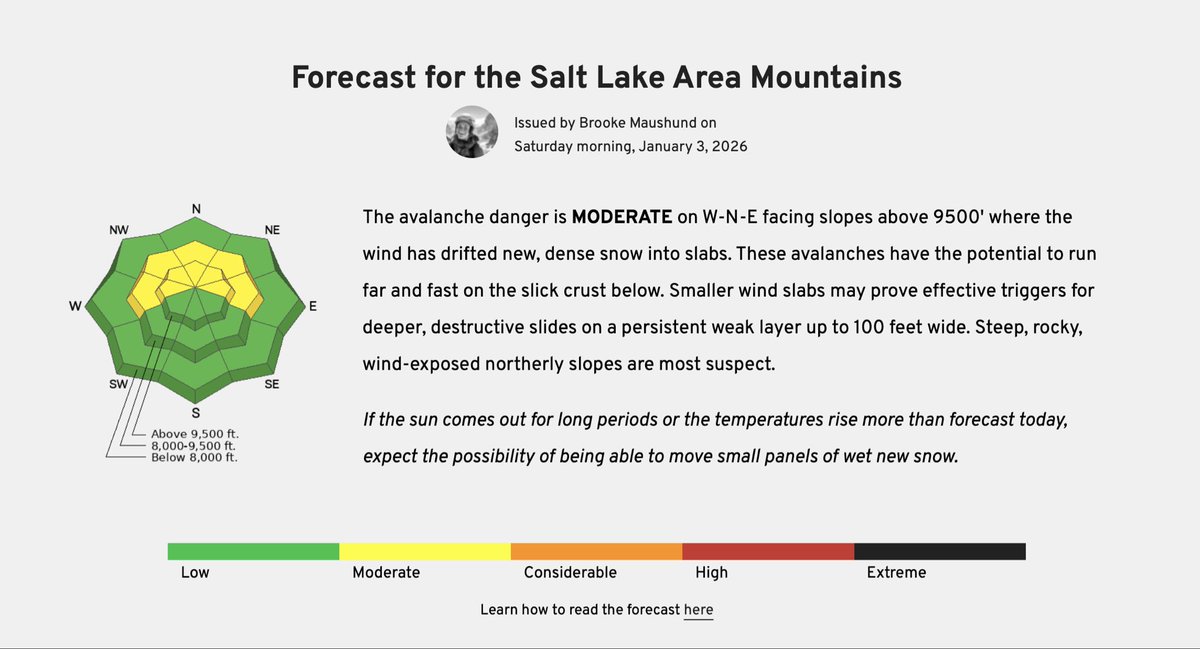
The avalanche danger is MODERATE on W-N-E facing slopes above 9500' where the wind has drifted new, dense snow into slabs. Smaller wind slabs may prove effective triggers for deeper, PWL slides. https://t.co/F7U6mPqKX9
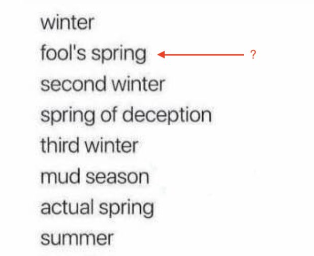
Sunday, December 14th, 2025: Are we experiencing fool’s spring this week, or did fool’s winter just get us last weekend? Either way, danger is MODERATE on high W-N-E slopes where you can trigger a slide 1-2’ deep on our buried PWL https://t.co/F7U6mPqd7B
Friday, Dec 5th, 2025: While many slopes didn’t have much snow before this storm, danger will rise to CONSIDERABLE in high northerly terrain by the end of the day. Temps and snow levels will rise during a wet, warm, and windy storm throughout the day. https://t.co/F7U6mPqKX9
December 3rd, 2025: Yesterday we started issuing daily hazard ratings. While most terrain is at LOW or NO danger (due to the lack of snow on the ground), areas of MODERATE avalanche danger exist on mostly shady (W-N-E) slopes above 9000’. https://t.co/0rbICn6uAo
This September is the 32nd UAC Backcountry Benefit. Gather round and get down with us to kick off the winter season in style.
Get your tickets and info through our website, grab your friends, dress to impress, and we’ll see you there!
The 32nd Annual Backcountry Benefit is happening on Thursday, September 11th from 6:00-10:00 PM. Save the date, take a date, and get your powder possee together to kick off the upcoming season!
Tickets and information available here: https://t.co/PP5wvOkYhd
Attn!! Late season backcountry closure for removing avalanche mitigation equipment, LCC Upper North Side. Starting 4am 4/29 until 5pm 4/29. Please check the map and steer clear of the area and working helicopter. Thanks!
Alta Ski Area is now open to Uphill Travel. Please avoid the Supreme lift line.
- Backcountry conditions exist
- Equipment may be encountered on the mountain
- There is no ski patrol
https://t.co/JFr6NXLNKi
@UACwasatch @WasatchBCAlli@AltaCentral
Did you know the UAC has a podcast? Join hosts Drew Hardesty and Ben Bombard and learn more about the topics and people behind the UAC.
https://t.co/5B6dzSrmR8