B.H.E.E.M. — Bharatiya Habitable Expandable Extraterrestrial Habitat.
When we returned from our training in Russia, we began the Indian leg of our astronaut training. This involved learning the systems of the launch vehicle and orbital module, along with extensive physical and spaceflight training.
But there was another, rather different, dimension to our training—academic research.
We were encouraged to pick a subject related to future space exploration, deepen our understanding of it, and, hopefully, contribute something that could be useful for India’s future space programmes.
I decided to look beyond the spacecraft we were training to fly in and think about where humans might live after we land.
My area of research was extraterrestrial habitats—the technologies and concepts that could eventually allow humans to live and work beyond Earth.
That work eventually resulted in B.H.E.E.M at the Aloke lab in @iiscbangalore.
There are enormous challenges to solve before humans can establish a sustained presence on the Moon, Mars, or other extraterrestrial destinations. From radiation and extreme temperatures to life support, energy, construction and the simple question of where do we live?
And that is precisely why we need to start thinking about it today.
If we want humans to live beyond Earth 20 years from now, the work cannot begin 20 years from now. It has to begin today.
The first step towards building a habitat on another world may not be laying its first brick.
It may simply be daring to imagine what that habitat could look like.
Details here ⬇️
https://t.co/WvXnw4g69n
#Shux #space #shubhanshushukla #india #bheem
The problem is not the poster with Vijay in it. The poster saying "Happy Ganesha Festival" has some other figure at the centre and Sri Ganesha in a corner!
🚨 ISRO set to launch world's highest resolution GEO imaging satellite & the first hyperspectral imager in GEO, this week! 🛰
Early Friday morning, ISRO's GSLV-F17 mission will launch GISAT-1A (aka EOS-05) which will become the world's first-ever Geostationary satellite to carry hyperspectral imagers (×2)!
It also carries two multispectral imagers, one of which, at a spatial resolution of 42 meters per pixel, will be the highest resolution camera ever in Geostationary Orbit!
It will provide a 567x improvement in pixel density over ISRO's current best GEO imaging capabilities!
But India already has much better EO satellites in Low Earth Orbit (LEO) and Sun Synchronous Orbit (SSO), why do we need GISAT in GEO?
- In LEO and SSO, satellites continuously revolve around the Earth and as the Earth is also rotating beneath them, it may take a satellite days, if not weeks, to revisit a particular location it previously imaged to look for any changes since its last pass.
And due to the low distance to Earth, they can only capture relatively narrow strips of the surface at a time. Thus, in order to image a larger area, they need to do so strip by strip over multiple orbits, which can also take weeks.
However, a satellite placed in GEO always remains stationary over the same region on Earth, meaning it can monitor a location for a prolonged period without having to wait till it passes over the same region again.
Its much higher altitude also gives it a very wide field of view, so it can image a massive area in a single go without having to build the image strip by strip.
That being said, the greater distance also significantly impacts the spatial resolution of the imaging payload.
Despite this, ISRO have designed the MX-VNIR payload on GISAT-1A to have a remarkable spatial resolution of 42 m/px, which is extraordinary not only because of the distance from Earth, but also because it is a multispectral imager!
Normally, the highest resolutions of EO satellites come from panchromatic (grayscale) imagers, while multispectral imagers tend to have lower resolutions as they split the incoming light into multiple color channels. But ISRO's MX-VNIR beats out even the best panchromatic imagers in GEO!
And given that it will be in GEO, it can deliver pictures covering almost the entire Indian subcontinent upto once every 10 minutes, and has the capability to image as much as entire South Asia in one go!
This is invaluable for rapidly evolving events such as floods, cyclones, wildfires and other natural disasters, allowing the authorities to track their progression almost in real-time rather than simply comparing before-and-after images.
GISAT-1A's suite of multispectral and hyperspectral payloads will not only allow it to take detailed images of the Earth, but can also tell the distributions of natural resources, health of crops and vegetation, pollution or algae in water bodies, and can potentially even uncover camouflaged hostile military installations etc. in images of enemy territory!
Thus, this satellite is intended for use in a wide range of applications such as agriculture, forestry, water body monitoring, minerology, oceanography and defense applications.
GISAT-1A is the successor and replacement of the GISAT-1 satellite that was lost in the failed GSLV-F10 mission in August 2021.
I read the following quote many years back: "The world shall end not because of the lack of wonders but because of the lack of wonders". It's heartening to see a 11 year old writing about his trip to beautiful Greek islands with such brilliance.
@nikhilnarayanan@the_hindu Superb! The kid is natural! His observations, experience are beautifully penned down. I always wonder why do we as adults loose the ability to wonder and take full experience of the place!
@Daye_Karune@PunishedKebbin Also, non vedic temples had their own rules! It all depends upon the Yajamana: The one who visualised the temple, gave land, did sacrifice to build the temples and the Tanthri who does prana pratishta, sets rules according to the Yajamana's wishes.
@Daye_Karune@PunishedKebbin True! All has good access now. It was at times when each group in Kerala had a different aradhana style. These rules were only for temples which follows Kerala Tantra codified under Tantra Samuchaya text of "Chennas" Tanthri Family! Many Thantris follow this text!
Kshetra has a maryada/rules to be followed and Namboothiris/Brahmins who through lineage are bound to do Dharma Paripalanam or propagating Dharma, rituals would automatically have more duties as well as access in temples akin to all professions!
Kerala "Temples/Kshetrams" follows vedic rituals and is governed under Tantra-Samuchaya! Those groups who follow the same path has entry and rightly so. Namboothiris have no say many "temples" which does not follow vedic rituals. 1/n
In a major Kerala Hindu temple, five concentric enclosures (Pancha Prakara) historically graded access by caste purity. Only Nambudiri priests entered the innermost Sreekovil. Other Nambudiris and, with lesser rights, Tamil Brahmins used the Namaskara Mandapam; Ambalavasis generally stopped short of it. Higher Nairs, and in social standing Syrian Christians, reached the Nalambalam; Goan GSBs were usually excluded and built their own temples. Intermediate castes approached the Vilakkumadam. Dalit and Adivasi communities were barred from the premises and nearby roads, crossing zero thresholds.
Except for Tanthri who does parana-pratishta even any Namboothiris who is not officially either Mel Shanti or Kizh Shanti can enter Sanctum Sanctorm! Even during certain rituals no one is allowed (even so called Brahmins) inside the main corridor.
@viprabuddhi It is true that MAQ was neglected over the years, however there are two trains to Bangalore. 1.Kannur-MAQ-Sakleshpur-BLR 2. MAQ(earlier starts from KNR)- Shoranur - BLR. Half of Kerala didn't had any trains to BLR and this one did help us.
@Balunatesh Note : Back in 2003/04 NDA govt led by then PM Vajpayee & nitish kumar as RM said mangalore will be part of SWR after Hassan - mangalore GC ..it was UPA govt who cancelled it and didn't implement it ..here is the official docs
In this well curated video there is not even a single frame which shows a single Chinese soldier anywhere close to the disaster hit area. Lots of stock videos have also been used! We saw similar videos during COVID. Our media had moved from GLOF theory to ice-rock avalanche.
Recycled footage being passed off as this disaster:
• Columbia Glacier, Alaska – helicopter clip by Leigh Coates posted 22-24 August (before the event even happened)
• Dharali flash flood, Uttarakhand, India – August 2025 •
Hpakant landslide, Myanmar – January 2024
• Yellowstone River flood, Montana, USA – June 2022 • Multiple AI-generated “entire village swallowed” clips already flagged with watermarks.
We saw similar ones during COVID !
What a stark Contrast in Disaster Management between BJP and Congress. In 2013, after the Kedarnath floods (16–17 June), Congress party relief trucks sat in Delhi until Sonia Gandhi and Rahul Gandhi, who had been abroad, could hold a ceremonial flag-off from AICC headquarters on 24 June, eight days later. Those same trucks then ran out of diesel and stranded en route because drivers were given only ₹2,000 for fuel.
Then Uttarakhand Congress government itself was criticised for slow initial response and unpreparedness; a later CAG report said official machinery had little grasp of the scale from 15–17 June and only reached the site by helicopter on 18 June. Army, IAF and ITBP did all the actual heavy lifting.
Today’s three IAF flights carrying 57.5 tonnes plus medical and tunnel-rescue teams to Nepal, a foreign country, show the difference between prompt operational aid and waiting for a photo-op.
#Nepal flood disaster.
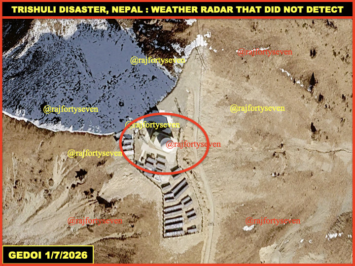
In the melee of rescue efforts, no one has yet asked #CCP’s #China as to why their so called weather #radar above the #Trishuli border did NOT warn #Nepal govt or at least the border posts at #Rasuwa.
Got the Raksha from my sis yesterday along with her prayers. Even though we live down south, Raksha Bandhan was one of the festival we celebrate thanks to my childhood in NI.