🌀 Polo is back at Category 5 with a clear eye and 260 km/h (160 mph) winds.
Its 892 hPa minimum is the Eastern Pacific’s second-lowest, after Patricia’s 872 hPa (2015).
Try the new hurricane tracker in the Ventusky app!
#Polo#Hurricane#Ventusky
Learning to fly means learning to understand the weather. ✈️
Flight instructor Michael Bourgeois uses Ventusky to teach future professional pilots about fronts, jet streams, air masses and winds at different flight levels.
https://t.co/uH1VJ0FUPE
⚠ Typhoon Dujuan is moving northwest toward Japan and is expected to reach the Kanto and Tokai regions on Monday. The storm could bring heavy rainfall and very strong winds, with gusts of up to 180 km/h in the Izu Islands and Kanto region. Follow the latest forecast and track the typhoon on Ventusky: https://t.co/tG6jbyUsdy
📌As the polar stratosphere cools in autumn, the polar vortex begins to develop around the North Pole. This year, however, its development could be strongly influenced by the ongoing El Niño, which is associated with enhanced planetary wave activity. Stronger planetary waves can propagate into the stratosphere, disturbing and weakening the polar vortex. ⚠This could have important consequences for winter circulation and weather patterns across the mid-latitudes of the Northern Hemisphere. https://t.co/XFPFhwaAj4
A shift to autumn weather is coming to Europe. 🤓 Temperatures in France will exceed 30 °C today, while tomorrow much of Central Europe will still see highs above 25 °C. ☀️ However, these are likely to be among the last truly summer-like temperatures in these regions this year. A cold front is approaching from the west (see video), and over the next 48 hours it will bring a noticeable drop in temperatures, effectively marking the definitive arrival of autumn across Europe. 🍂🍁🍃
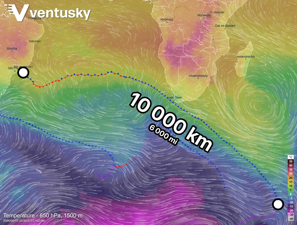
A vast frontal boundary will stretch across the Southern Hemisphere tomorrow, from Antarctica through Cape Town all the way to Rio de Janeiro. 🤓 The entire system will span an impressive 10,000 km, beautifully illustrating just how interconnected our weather is. 🤗 It will bring heavy rainfall to both major cities. Cape Town and southern Africa will also see powerful wind gusts and high waves: https://t.co/Sk6uG63Xoj
Will a medicane form in the Mediterranean tomorow? 🧐🌀 The Atlantic has gone a record-long time without a hurricane, so attention is shifting to the Mediterranean, where a low-pressure system is developing near Libya. It is expected to move toward southern Greece in the coming days. 🤓It will most likely not reach medicane status (tropical-like cyclone). Medicanes typically have a warm core aloft and tropical-cyclone characteristics, while current forecasts suggest this will remain a more conventional low: https://t.co/bawdh5hpHZ Even so, it should look very distinctive on weather maps and bring heavy rainfall to parts of the region: https://t.co/BcaajlOx4s
@KutayMihliardic Bir medicane'in tipik özelliklerinden biri olan sıcak çekirdeğin oluşması beklenmiyor: https://t.co/XJ9OkbVnw6
Bu nedenle büyük olasılıkla sadece normal bir alçak basınç sistemi olacak.
@NickJF75 A warm core, which is a typical feature of a medicane, is not expected to develop: https://t.co/XJ9OkbVnw6 It will therefore most likely be just a regular low-pressure system.
@WeatherActionEU A warm core, which is a typical feature of a medicane, is not expected to develop: https://t.co/XJ9OkbVnw6 It will therefore most likely be just a regular low-pressure system.
@MatthewCappucci A warm core, which is a typical feature of a medicane, is not expected to develop: https://t.co/XJ9OkbVnw6 It will therefore most likely be just a regular low-pressure system.
@louisyagera@SamiaBenahmed8@RealityCreation Our app for iOS and Android uses a 3D globe: https://t.co/g9eJt4XTW6 You can view the data there without the Mercator projection.
Antarctica has been experiencing a prolonged period of below-average temperatures. 🥶 In recent days, stations have reported temperatures below -74 °C / -100 °F, the lowest for this time of year since September 2023, which was also very cold. 🧐 Cold air is also spreading toward nearby continents. South America experienced below-average temperatures in recent days, while southern Africa and Australia are expected to see cold conditions in the coming days: https://t.co/p5IAVBWddg
Ventusky v56 is out! 🌀
• Tap cyclone track points for details
• Faster loading & animations
• Synced custom color scales
• Better search
• Full timeline + auto model switching
• Saved precipitation intervals
• Active fire alerts
Update your app!
https://t.co/KLOVewic6F
Large amounts of Saharan dust have been continuously spreading over the Atlantic for several weeks, and the situation is expected to remain much the same next week (see video or map https://t.co/8XERhg0SSd). 🧐 Such a prolonged and intense transport of Saharan dust over the Atlantic has not occurred in recent years. 🏜️ This is also one of the reasons why no hurricane has formed in the Atlantic so far this season.
📌A strong temperature contrast is affecting the Balkans today, with much colder air over the northwest meeting significantly warmer air farther east and south. These pronounced temperature anomalies, with values well below average in the northwest and above average farther east and south, are creating a sharp thermal gradient associated with a frontal boundary, along which thunderstorms and heavy precipitation are developing. 🌧🌧 Such strong temperature differences can contribute to atmospheric instability and, together with moisture and the lifting along the front, support locally intense storms, heavy rainfall, and strong wind gusts. https://t.co/1odoGHvnOF
⚠ Heavy rainfall is expected across the western half of Slovenia, northeastern Italy and parts of Croatia through the end of the week. Locally, rainfall totals could reach up to 180 mm. 🌧️🌧️The heavy precipitation will develop along the boundary between colder air advancing from the northwest and warm, moisture-rich air over the Mediterranean, creating favorable conditions for intense rainfall. Follow the forecast on Ventusky: https://t.co/MaJDoKlqg5
The warm weather across much of Europe will be at least temporarily brought to an end by a strong cold front next week. 🤓🌧️ It will arrive from the Atlantic and bring cooler conditions to most of the continent during the first half of the week. Rainfall will accompany the front as well. Temperatures that are well above average will therefore drop to around average or below average levels (see the temperature anomaly and frontal map): https://t.co/rL0CpDiaWE
🌀 #Hurricane#Lowell is currently a powerful Category 3 storm over the Pacific, with forecasts indicating a sharp northward turn that could bring it dangerously close to the Hawaiian Islands early next week. 📍 The latest projections suggest the center could pass roughly 200 miles southwest of Kauai around September 8, although the exact track remains uncertain. 🌊 The Central Pacific hurricane season is active this year, with Lowell adding to the ongoing tropical activity across the region. https://t.co/dNERC2yFVg
For now, this is more of a meteorological curiosity - the GFS model suggests that a tropical cyclone could reach as far as Los Angeles in about a week. 😳🧐 However, such a scenario is very rare. Tropical cyclones are extremely uncommon in this city; the last one was observed there in 1939. In any case, the Pacific hurricane season has been very active so far, largely thanks to El Niño. See wind forecast: https://t.co/DVReNOj4Sr