WE DID IT! For the first time in almost 6 months, we received more daylight than darkness today (12 hours & 23 seconds of daylight). So long, dark side!
SNOW UPDATE: Temperatures are tumbling rapidly behind the cold front this afternoon. Rochester dropped 20° in an hour and will continue dropping into the evening hours. A reinforcing wave of energy will support a surge of widespread precipitation returning around nightfall. Any rain will quickly transition to a period of sleet and then snow, which could be heavy at times.
Right now, it appears the window of snow will favor 8pm-1am (give or take), so it's quite limited. That said, it'll be wet & heavy during that time, so several inches of dense snow accumulation will be possible. Also worth noting, our temperature drop will present additional travel issues as a layer of black ice could be masked by this snow accumulation.
This will be far from a snowstorm. While the snow totals won't be particularly impressive, the prospect of icy travel & continued strong wind gusts will make for a very wintry night across WNY. The landscape will look VERY different around here by tomorrow morning.
Widespread light to moderate snow is expected across the region tonight through Wednesday. Snow will taper off across western NY on Wednesday, though snow will continue across the Tug Hill region into Wednesday evening. Winter weather advisories are in effect as shown.
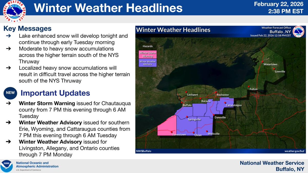
A Winter Storm Warning and Winter Weather Advisories are in effect for portions of Western New York. Steady snow will continue for WNY, with some heavier snow starting this evening for areas south of Buffalo, Batavia and Rochester.
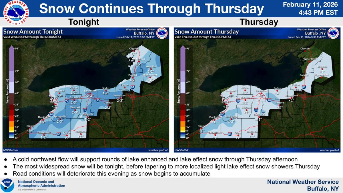
Lake enhanced snow will continue through Thursday. The most widespread snow will be tonight before giving way to more localized lake effect snow showers Thursday. Travel conditions will deteriorate this evening with snow covered roads and reduced visibility. #nywx
MCSO's Snowmobile Unit: Before you head out on the trails, be a responsible rider. Sleds must be registered and insured - registration fees help fund the trails you enjoy.
We are out there patrolling to ensure your safety and enforcing the various snowmobile laws. A reminder, don't drink and drive.
Whether Punxsutawney Phil saw his shadow or not this morning… DOESN’T MATTER!
You live in NY. You already knew the answer... ❄️Winter isn’t over yet and more snow will be here soon.
Slow down and #DontCrowdThePlow
It’s winter in NY. Drive like it.
Penguins at the Pittsburgh Zoo & Aquarium play in the snow thanks to the recent snow storm.
“Many of the animals like our big cats and elephants enjoy a snow day when they get the opportunity to play in frigid white powder,” the zoo said.
“Animal keepers will bring snow inside for some of our residents like gorillas and siamangs to experience.”
“Penguins love to venture outdoors for a taste of their native waddling grounds, while otters think ice is nice and frolic in their pools with frosty treats.”
“Most of our animals are innately curious and enjoy investigating the foreign weather phenomena.”
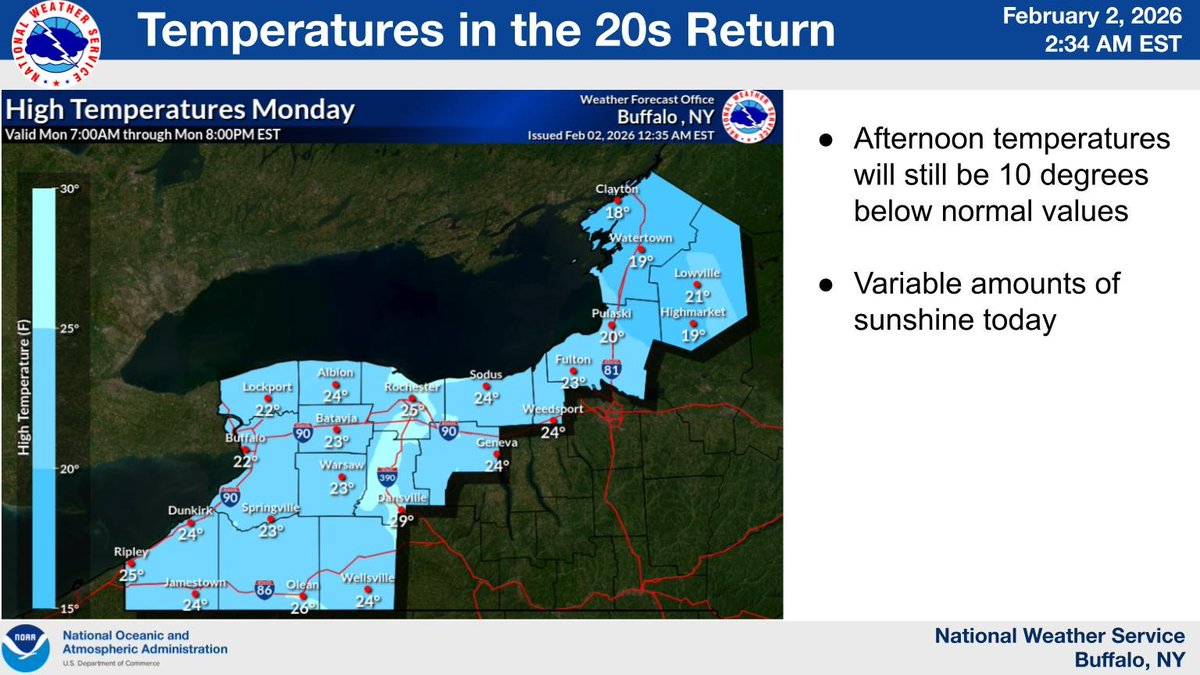
After a nine day period of temperatures in the teens and colder, our region will return to afternoon temperatures reaching the 20s. Even still these values will be nearly 10 degrees below early February normal.
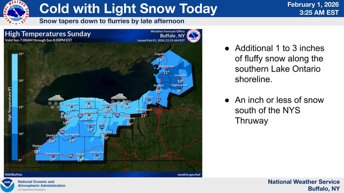
Northwest flow of cold air over Lake Ontario today will yield a few fluffy inches of snow along the shoreline, with an inch or less farther inland. Activity diminishes through the afternoon hours.
Today will be milder, with morning low clouds and fog dissipating from west to east. Tonight and Friday will then be unseasonably mild and increasingly windy, with occasional showers later tonight and Friday.
Today will feature some of the coldest temperatures thus far for the season for many areas. Temperatures for most areas will be at least 10 degrees and even close to 20 degrees below normal.
Light to moderate snowfall is expected to continue through the 1st half of today. While accumulations overall will be more on the minor side, snow will peak in coverage and intensity during the morning commute today. If traveling allow extra time to reach your destination.
A Winter Storm Watch has been issued for counties east of the lakes beginning Wednesday evening. Heavy lake effect snow and gusty winds are possible through Thanksgiving and Friday.
Additional details can be found below and at https://t.co/DyIwve7965