As usual, thermodynamic profiles, storm mode, and areas of greatest concern will remain in question for quite some time. Currently, the NAM shows a more robust skew-T in some spots while the GFS keeps our atmosphere stable with lingering rain/cloud cover (2/2) #mdwx#dcwx#vawx
It appears that our next risk for strong storms in the Mid-Atlantic will be around Monday, as a surface low slides across the OH valley into the northeast, allowing for southwesterly flow to overspread the area, w/ winds veering as you increase in altitude (1/2) #mdwx#dcwx#vawx
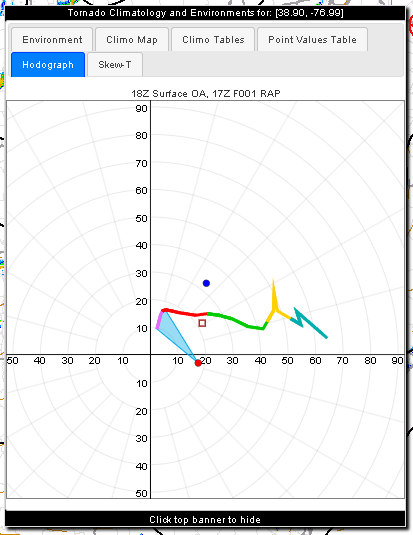
A factor to consider tomorrow is how fast translational speeds will alter ground-relative winds in potential tornadoes. It may not take all that strong of a vortex to achieve sigtor level winds in their right front quadrants.
Large amount of supercells currently in PA, some tornado warned, and there have already been confirmed tornadoes. Your wind profile is helping these develop and sustain themselves #pawx
SKYWARN AMATEUR RADIO NETWORK HAS BEEN ACTIVATED for 10 forecast zones in [AN] and District of Columbia [DC] and 21 forecast zones in [MD] and 29 forecast zones in [VA] and Berkeley, Eastern Grant, Eastern Mineral, Eastern Pendleton... till 11:00 PM EDT https://t.co/RNbzfq5Bv3
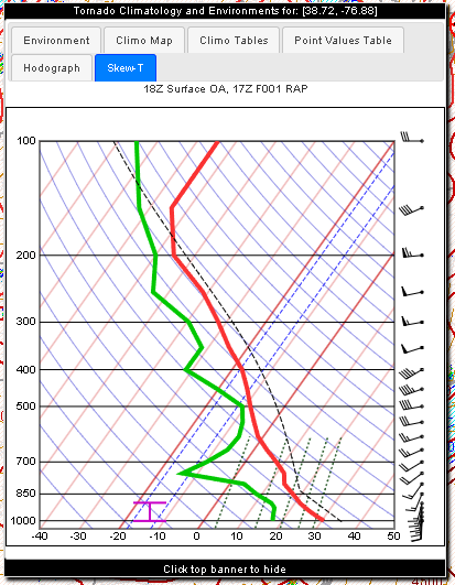
Here is your 18z IAD sounding (in sounderpy dark mode for eye candy) and there is definitely more overall shear overlapping with the cape profile compared to what we had last week, so expect storms to behave a bit differently
Mid-Atlantic gang, particularly near the Chesapeake — an isolated tornado remains possible today.
We have ample storm fuel and we have changing winds with height.
A subtle easterly component to surface winds, especially near the Bay, will bolster low-level helicity (twist).
Perhaps there could also be a tornado threat as we go into the evening, with some streamwise vorticity possibly being available to storms (storm relative inflow vector is quite perpendicular to LL shear vector) #mdwx#dcwx#vawx
A lee trough (elongated area of low pressure east of mtns) should help initiate our storms in the DMV soon. Deep layer shear seems sufficient enough for sustained convection, but there is uncertainty as to how much instability (and capping) there will be later #mdwx#dcwx#vawx
A lee trough (elongated area of low pressure east of mtns) should help initiate our storms in the DMV soon. Deep layer shear seems sufficient enough for sustained convection, but there is uncertainty as to how much instability (and capping) there will be later #mdwx#dcwx#vawx
FOR THE FIRST TIME IN 53 YEARS, THE KNICKS ARE NBA CHAMPIONS 🏆
New York defeats San Antonio 4-1 in the NBA Finals, capturing their third championship in franchise history!


![iembot_lwx's tweet photo. SKYWARN AMATEUR RADIO NETWORK HAS BEEN ACTIVATED for 10 forecast zones in [AN] and District of Columbia [DC] and 21 forecast zones in [MD] and 29 forecast zones in [VA] and Berkeley, Eastern Grant, Eastern Mineral, Eastern Pendleton... till 11:00 PM EDT https://t.co/RNbzfq5Bv3 https://t.co/fTS1sAhCOC](https://pbs.twimg.com/media/HKzZVK8XUAA04ff.jpg)


